Drina
| Drina | |
|---|---|
 The Drina River near Mali Zvornik, Serbia | |
| Country | Bosnia and Herzegovina, Serbia, Croatia |
| Basin | |
| Main source | Bosnia and Herzegovina, between the slopes of the Maglić and Pivska planina mountains |
| River mouth | Sava, at the Serbian-Bosnian border between Crna Bara and Bosanska Rača |
| Basin size | 19,570 km2 (7,560 sq mi) |
| Physical characteristics | |
| Length | 346 km (215 mi) |
| Discharge |
|
The Drina (Serbian Cyrillic: Дрина, pronounced [drǐːna]) is a 346 km (215 mi) long international river, which forms a large portion of the border between Bosnia and Herzegovina and Serbia. It is the longest tributary of the Sava River and the longest karst river in the Dinaric Alps which belongs to the Danube river watershed. Its name is derived from the Latin name of the river (Latin: Drinus) which in turn is derived from Greek (Ancient Greek: Dreinos).
Length and navigation
The Drina is formed by the confluence of the Tara and the Piva rivers, both of which flow from Montenegro and converge on the border of Bosnia and Herzegovina, at Hum and Šćepan Polje villages. The total length of the Tara river is 144 km (89 mi), of which 104 km (65 mi) are in Montenegro, while the final 40 km (25 mi) are in Bosnia and Herzegovina along which form the border between the two countries in several places. The Drina flows through Bosnia and Herzegovina northward for 346 km (215 mi), of which 206 km (128 mi) is along the border of Bosnia and Herzegovina and Serbia, and finally spills out into the Sava river near Bosanska Rača village in northeastern Bosnia and Herzegovina. Measured from the source of the Tara, its longer headwater, the Drina is 487 kilometers (303 miles) long.
The river is not navigable; however, together with the Tara it represents the main kayaking and rafting attraction in Bosnia and Herzegovina and Montenegro.
Course
Origin and gorges

The Drina originates between the slopes of the Maglić and Pivska planina mountains, between the villages of Šćepan Polje (in Montenegro) and Hum (Bosnia and Herzegovina). At its origin, it flows west, then makes a large curve to the northeast, around the Maluša mountains. Next, it flows through the villages of Kosman, Prijedjel, Dučeli, Čelikovo Polje, Kopilovi, Trbušće, Brod and the town of Foča. It receives the Sutjeska, Bjelava and Bistrica rivers from the left and the Ćehotina at Foča from the right.
Here the Drina carved the longest one of the several gorges on its course, the 45 km (28 mi)-long Suhi Dol-Biserovina gorge between the southernmost slopes of the Jahorina mountains from the north and the Kovač mountains from the south. The villages of Zlatari, Jošanica, Ustikolina, Cvilin, Zebina Šuma, Osanica, Kolovarice, Vranići, Mravinjac, Biljin, Vitkovići and Zupčići are located in the gorge, as well as the town of Goražde. The river receives the Kolunska rijeka and the Osanica as tributaries from the left.
The Drina continues to the northeast, flowing close to the villages of Žuželo, Odžak, Kopači and Ustiprača, entering the 26 km (16 mi) long Međeđa gorge carved between the Vučevica mountains from the south and the southern slopes of the Devetak mountains from the north. The narrowest part of the Međeđa gorge is Tijesno, the 8 km (5.0 mi)-long section of the gorge where the river is at its narrowest (only 12 m (39 ft) wide), but also at its deepest (12 m). Here it receives the Prača river from the left and the Janjina and Lim rivers from the right. The villages of Trbosilje, Međeđa and Orahovci are located in the gorge, which is for the most part flooded by the artificial Višegrad lake, created by the Višegrad hydroelectric power plant.

At the town of Višegrad, the Drina receives the Rzav River from the right and turns northwest at the Suva Gora mountain into the Klotijevac gorge. The gorge is 38 km (24 mi) long and up to 1 km (3,200 ft) deep, carved between the mountains of Bokšanica (from the west) and Zvijezda (from the east). The villages of Sase, Resnik, Đurevići and Gornje Štitarevo lie in the gorge and the Kukal river flows into the Drina from the right. At the Slap village, the Drina receives the Žepa river from the right and turns sharply to the west, becoming a border river between Bosnia and Herzegovina and Serbia near the village of Jagoštica.
Border river
The Drina flows between the mountains of Zvijezda and Sušica and it is flooded by the artificial Lake Perućac on the northern slopes of the Tara mountain, created by the Bajina Bašta power plant. The villages of Prohići and Osatica (in Bosnia and Herzegovina) are located on the lake, as well as the ruins of the medieval town of Đurđevac. The river is dammed at the village of Perućac, where a strong well springs out from the Tara mountain, flowing into the Drina as a waterfall. In addition, the waters of Drina are used for several fish ponds for the rainbow trout spawning.
The river continues to the villages of Peći, Dobrak, Skelani (in Bosnia and Herzegovina) and Zaguline (in Serbia), reaching the town of Bajina Bašta. At the villages of Donja Crvica and Rogačica, the Drina makes a large turn, completely changing its direction from the northeast to the northwest. This distinct geographical feature forms the Osat and Ludmer regions of Republika Srpska, Bosnia and Herzegovina, which are separated by the river from the Azbukovica part of the Podrinje region of Serbia.
Upper Drina
Flowing on the western slopes of the Bukovica mountain, the Drina passes next to the villages of Gvozdac, Okletac, Strmovo, Bačevci, Donje Košlje, Drlače, Vrhpolje, Donja Bukovica (in Serbia), Boljevići, Fakovići, Tegare, Sikirići and Voljevica (in Bosnia and Herzegovina), before it reaches the towns of Ljubovija in Serbia, the centre of the Azbukovica (or Upper Podrinje) region, and Bratunac, in Bosnia and Herzegovina, the center of the Ludmer region. Here the Drina receives the right tributary of Ljuboviđa and continues between the mountains of Jagodnja and Boranja (in Serbia), and Glogova (in Bosnia and Herzegovina). After the ruins of the medieval town of Mikuljak and the villages of Mičići, Uzovnica, Crnča, Voljevci (in Serbia), Krasanovići, Dubravice, Polom and Zelinje (in Bosnia and Herzegovina), the Drina is flooded again, this time by the artificial Lake Zvornik, as a result of the Zvornik power plant. The villages of Amajic, Culine (in Serbia), Sopotnik, Drinjača and Djevanje (in Bosnia and Herzegovina) are located on the lake. This is also where the Drinjača river flows into the Drina (now the Zvornik lake) from the left, flowing from the Bosnian region of Gornji Birač.
Lower Drina

After the dual town of Zvornik (Bosnia and Herzegovina)-Mali Zvornik (Serbia), the Drina flows between the Bosnian mountain of Majevica and the Serbian mountain of Gučevo, and enters the Lower Podrinje region. For the rest of its flow after the village of Kozluk, it has no major settlements on the Bosnian side (except for the town of Janja, which is several km away from the river, and some smaller settlements, like Branjevo and Glavičice). On the Serbian side, the Drina passes next to the villages of Brasina and Rečane, the ruins of the medieval town of Koviljkin grad, the spa and town of Banja Koviljača, the industrial town and center of the Podrinje region, Loznica, and its largest suburb, Lozničko Polje.
Lowest section
The Drina enters the lowest section of its course, the southern Pannonian plain, including the Serbian regions of Jadar (where it receives the Jadar river) and Iverak (where it receives the Lešnica). This is where the rivers spills in many arms and flows, creating the largest flood plain in former Yugoslavia, which the river divides in half. The east side, Mačva, is in Serbia, and the west side, Semberija, in Bosnia and Herzegovina (where it receives the Janja river). The Drina spills over and meanders, forming shallows, islands and sandbars, before emptying into the Sava river between the Serbian village of Crna Bara and the Bosnian Bosanska Rača. The variability of the water flow and low altitude resulted in several course changes during history. The Drina previously flowed into the Sava river near Šabac, 30 km (19 mi) to the east of the present mouth.
Characteristics
Like the Velika Morava, the Drina is also a meandering river, with a very high meandering ratio (175:346), still slightly less than that of Velika Morava.
The Drina is a very fast river with cold and greenish water, which is from the limestone that underlays the area in which the river carved its bed.
Its average depth is 3 to 5 m (9.8 to 16.4 ft), the deepest being 12 m (39 ft) at Tijesno. On average, the Drina is 50–60 m (160–200 ft) wide, but it ranges from only 12–20 m (39–66 ft) at Tijesno to up to 200 m (660 ft) at Bajina Bašta and Ljubovija.
The drainage basin covers 19,570 square km (4.8 million acres), branching into Bosnia and Herzegovina, Serbia, Montenegro, and Albania. The Drina belongs to the Black Sea drainage basin.
Before it was regulated by the several power stations, the Drina used to flood its valley. The most disastrous flood occurred in 1896, which destroyed the town of Ljubovija.
Tributaries
Major left tributaries: Sutjeska (at Kosman), Bjelava (at Trbušće), Bistrica (at Brod), Kolunska rijeka (at Ustikolina), Osanica (at Osanica), Prača (at Ustiprača), Žepa (at Slap), Drinjača (at Drinjača), Kamenica (at Djevanje), Sapna (at Karakaja) and Janja (at Janja).
Major right tributaries: Ćehotina (at Foča), Janjina (at Samobor), Lim (the longest one, 220 km, at Brodar), Rzav (at Višegrad), Kukal (at Đurevići), Rogačica (at Rogačica), Trešnjica (south of Ljubovija), Ljuboviđa (at Ljubovija), Jadar (at Straža) and Lešnica (at Lešnica).
Power
The Drina originates at an altitude of 432 meters (1,417 feet) and flows into the Sava at 75 meters (246 feet). The large inclination is not constant because of many gorges and bends, but still more than enough to generate an estimated 6 billion kilowatt-hours of potential electrical power.
Also, the discharge steadily grows: 125 cubic metres per second (4,400 cu.ft./s) at the Ćehotina's mouth, and 370 cubic metres per second (13,000 cu.ft./s) on the Drina's mouth into the Sava. However, power capacity is not fully used since only three hydro electrical power stations (HE) have been constructed so far: HE Zvornik, HE Bajina Bašta, and HE Višegrad.
Population
As a result of the inhospitable terrain and the lack of good railways and major roads, the surrounding territory is sparsely populated. Apart from many small villages, the major settlements on or near the river are:
- in Bosnia and Herzegovina: Foča, Goražde, Višegrad, Srebrenica, Bratunac, Zvornik, and Janja.
- in Serbia: Bajina Basta, Ljubovija, Mali Zvornik, Banja Koviljača, Loznica, Lozničko Polje, and Badovinci.
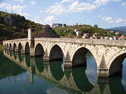
The Drina is crossed by several bridges: at Višegrad, Skelani, Bratunac and Zvornik (in Bosnia and Herzegovina), and Loznica and Badovinci in Serbia. The most recent bridge is the one at Badovinci, the Pavlovića ćuprija.
In popular culture
In its lower, meandering course, the Drina is referred to as the kriva Drina ("bent Drina"). This has entered the Bosnian and Serbian languages as a phrase used when someone wants to resolve an unsolvable situation; it is said that he or she wants to "straighten the bent Drina".
During World War I, from September 8 to September 16, 1914, the Drina was the battlefield of bloody battles between the Serbian and Austro-Hungarian army, the Battle of Cer and Battle of Drina. In honor of the former battle, the Serbian composer Stanislav Binički (1872–1942) composed the famous March on the Drina, and in 1964 a movie of the same title was shot by director Žika Mitrović. The movie was later banned for a period of time by the Communist government, because of its portrayal of a true-to-life, bloody battle, and its use of Binički's march (banned at that time) as part of the soundtrack. The Slovenian band Laibach did a cover version of the March on the Drina titled Mars on the River Drina in their album NATO, released in 1994 during the Yugoslav Wars.
The largest impact the river has had in culture probably is the 1945 novel "Na Drini ćuprija" (The Bridge on the Drina) by the Nobel Prize laureate, Ivo Andrić; the book is about the building of a bridge near Višegrad by the Ottomans in the 16th century.
See also
- Tara (Drina)
- Piva (river)
- Neretva
- Mehmed Paša Sokolović Bridge
- Sutjeska National Park
- Drina Regatta
- List of national parks of Bosnia and Herzegovina
References
External links
- Commission to Preserve National Monuments of Bosnia and Herzegovina
- Official website
- Sutjeska National Park - BH Tourism Official website
- Cultural and Historical information
- Hydroelectric Power Plant BUK BIJELA
- Hydroelectric Power Plant FOČA
- Hydroelectric Power Plaint ZVORNIK
- Mala Prosvetina Enciklopedija, Third edition (1985); Prosveta; ISBN 86-07-00001-2
- Jovan Đ. Marković (1990): Enciklopedijski geografski leksikon Jugoslavije; Svjetlost-Sarajevo; ISBN 86-01-02651-6
- Slobodan Ristanović: "Prvenac na Drini"
- Battle of the Drina
| Wikimedia Commons has media related to Drina River. |
Coordinates: 44°53′24″N 19°21′14″E / 44.890°N 19.354°E