Drighlington
| Drighlington | |
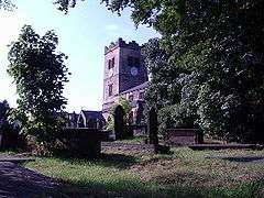 St Paul's Church |
|
 Drighlington |
|
| Population | 5,528 (2011) |
|---|---|
| OS grid reference | SE2229 |
| Metropolitan borough | City of Leeds |
| Metropolitan county | West Yorkshire |
| Region | Yorkshire and the Humber |
| Country | England |
| Sovereign state | United Kingdom |
| Post town | BRADFORD |
| Postcode district | BD11 |
| Dialling code | 0113 |
| Police | West Yorkshire |
| Fire | West Yorkshire |
| Ambulance | Yorkshire |
| EU Parliament | Yorkshire and the Humber |
| UK Parliament | Morley and Outwood |
Coordinates: 53°45′24″N 1°39′42″W / 53.756767°N 1.661639°W
Drighlington /ˈdrɪɡlɪŋtən/ is a village and civil parish in the City of Leeds metropolitan district, West Yorkshire, England. Historically part of the West Riding of Yorkshire, the village lies 5 miles (9 km) south west of Leeds and 4 miles (6 km) south east of Bradford. The name of the village is often shortened to Drig. The population of the civil parish at the 2011 Census was 5,528.[1]
History

The earliest mention of Drighlington is to be found in the Domesday Book where it is described as "Dreslintone",[2][3] and its modern name is derived from this root. The Roman road from York to Chester ran through the village and its mark may be seen in the more or less straight run from Birkenshaw to Drighlington traffic lights.
In 1576 Queen Elizabeth I granted Letters of Patent to one James Brooke allowing him to hold a market every second Thursday and two horse and cattle fairs annually. These fairs took place at the White Hart public house (now demolished).
The village is also the site of the Battle of Adwalton Moor fought on 30 June 1643 in the First English Civil War between the armies of King Charles I and the Parliamentarians. The Royalist army under the Earl of Newcastle defeated the Parliamentarians under the command of Lord Ferdinando Fairfax and his son Sir Thomas. There are four commemorative stones with plaques depicting the battle at strategic points around the common and there is an information board on the wall of the community hall.
James Margetson, a native of Drighlington, built and endowed the Drighlington Free Grammar School and endowed it (1678). It was replaced in 1875 by the Drighlington Board School.[4]
St Paul's Church was built in 1878 and the foundation stone was laid by the Lord of the Manor on 9 September 1876.
-

Lumb Hall, built for the Brookes family in 1640
-

Methodist church, 2000
-

Black Bull public house, 2008
-

Drighlington crossroads, 2008
Government
Since local government changes in 1974, Drighlington has been in the City of Leeds metropolitan borough, in the metropolitan county of West Yorkshire. The village once formed part of the former Municipal Borough of Morley, and is still classed as part of Morley in the census. However, it is technically separate and is not governed by Morley Town Council.[5] Since 2004, the village has had a parish council.
The metropolitan district includes other towns and villages with their own clear identity, such as Morley and Otley, as well as the city of Leeds. Drighlington is in the Morley North ward, which elects three councillors to Leeds City Council. Until the 2010 general election Drighlington was in the Morley and Rothwell parliamentary constituency, when it was transferred to the newly created constituency of Morley and Outwood. Drighlington has a Bradford postcode of "BD11" and the Royal Mail official address is "Drighlington, Bradford", while the village telephone numbers are "0113", the Leeds prefix.
The ecclesiastical parish of Drighlington was created in 1817. Drighlington was an urban district 1894-1937 and was part of Morley Municipal borough 1937-1974. Drighlington was part of the Bradford Registration district from 1837–1891 and North Bierley Registration district from 1892-1937.[6]
Geography
The village is at the junction of the A58 Leeds-Halifax road and the B6135 Tong to Gildersome Street road which used to be part of the A650 Bradford to Wakefield road. This junction is known as the Drighlington Crossroads. The A650 now bypasses Drighlington to the west of the village following part of the structure of what was the Bradford to Wakefield and London Great Northern Railway line.
Culture and community


Community facilities
The village has a Scout Group, Rainbow pack and a championship level contesting brass band with youth band. There is also the Tempest Constitutional Club.
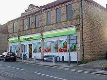
There are a small number of shops, a post office, a small library, a community centre and numerous public houses. On 21 February 2012, the library was open and run for the first time by volunteers from Friends of Drighlington Community. The village also has a Co-operative store situated in the original Co-operative buildings, with the words Drighlington Industrial Co-operative Society embossed along the roofline.
Morley, 2.5 miles (4 km) to the southeast, has numerous major high street stores in its town centre, including Morrisons and Asda, and an indoor market. The White Rose Centre, 3.5 miles (5.6 km) to the east, is an indoor shopping centre selling most high street brands and includes department stores and a supermarket.
Sport
Drighlington supports football, rugby league and cricket teams, including the Drighlington Amateur Rugby League Club, Adwalton Cricket Club, and Drighlington Cricket Club. There is "The Manor" golf course, a skate park, and a multi-use games area provided by the Parish Council.
Transport
The nearest suburban railway station is Morley, and the nearest mainline railway station is Leeds City railway station. The only public transport still available in the village is the bus. Morley also has a railway station, which offers rail links to Leeds city centre, Dewsbury, Huddersfield and Manchester.
| Company | Route | Destinations |
|---|---|---|
| Arriva Yorkshire | 209 | Heckmondwike, Birstall, West Yorkshire Retail Park, Gildersome, Leeds city centre |
| Arriva Yorkshire | 225 | Leeds city centre, Gomersal, Cleckheaton, Brighouse |
| Arriva Yorkshire | 254 | Leeds city centre, Birkenshaw, Cleckheaton, Heckmondwike, Dewsbury, Wakefield |
| Arriva Yorkshire | 255 | Leeds city centre, Birkenshaw, Cleckheaton, Halifax |
| Arriva Yorkshire | 425 | Bradford city centre, Morley, Wakefield |
| Arriva Yorkshire | 427 | Bradford city centre, Morley, Wakefield |
Education
The village has one school: Drighlington Primary School. There are no secondary schools in Drighlington, however there are three in neighbouring Morley and one in neighbouring Farnley; all of these are secular comprehensive schools.
Location grid
 |
Pudsey | | ||
| Birkenshaw | |
Gildersome | ||
| ||||
| | ||||
| Birstall |
References
- ↑ "Civil Parish population 2011". Neighbourhood Statistics. Office for National Statistics. Retrieved 25 February 2016.
- ↑ "Drighlington", Domesdaymap.co.uk. Retrieved 27 November 2011
- ↑ "Documents Online: Drighlington", Folio: 318r, 379v, Great Domesday Book; The National Archives. Retrieved 27 November 2011
- ↑ Church of England, Drighlington St Paul.
- ↑ "Bulletin of Changes to Local Authority Names in England" (The Leeds (Parishes) order 2004) p. 8. Office of the Deputy Prime Minister, October 2004. Retrieved 27 November 2011
- ↑ "Bradford Registration District", Genuki.org.uk. Retrieved 23 November 2007
External links
- "Drighlington", Genuki.org.uk. Retrieved 27 November 2011
- Drighlington Parish Council. Retrieved 27 November 2011
- Google Maps: Street Map and Satellite Image