Dougherty, Alameda County, California
| Dougherty | |
|---|---|
| Unincorporated community | |
 Dougherty  Dougherty Location in California | |
| Coordinates: 37°42′40″N 121°54′35″W / 37.71111°N 121.90972°WCoordinates: 37°42′40″N 121°54′35″W / 37.71111°N 121.90972°W | |
| Country | United States |
| State | California |
| County | Alameda County |
| Elevation[1] | 348 ft (106 m) |
Dougherty (also, Amador's, Amador Valley, and Dougherty Station)[2] is an unincorporated community in Alameda County, California. It is located just north of Dublin,[2] at an elevation of 348 feet (106 m).
James Witt Dougherty purchased the land here in 1852, including a two-story adobe building.[2] A community grew up around the adobe, and was first called Amador's and Amador Valley after Jose Maria Amador the original owner of Rancho San Ramon (Amador).[2] The post office arrived in 1860 and renamed the place Dougherty Station.[2] The southern part of the settlement broke off and became Dublin.[2] The post office was renamed Dougherty in 1896 and closed in 1908.[2]
References
- ↑ "Dougherty". Geographic Names Information System. United States Geological Survey.
- 1 2 3 4 5 6 7 Durham, David L. (1998). California's Geographic Names: A Gazetteer of Historic and Modern Names of the State. Clovis, Calif.: Word Dancer Press. p. 626. ISBN 1-884995-14-4.
Municipalities and communities of Alameda County, California, United States | ||
|---|---|---|
| Cities | 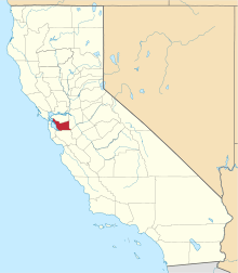 | |
| CDPs | ||
| Unincorporated communities | ||
| Former settlements | ||
This article is issued from Wikipedia - version of the 7/5/2016. The text is available under the Creative Commons Attribution/Share Alike but additional terms may apply for the media files.