Dorum
| Dorum | ||
|---|---|---|
| Ortsteil of Wurster Nordseeküste | ||
| ||
 Dorum | ||
Dorum in Wurster Nordseeküste 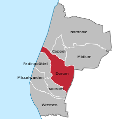
 | ||
| Coordinates: 53°40′28″N 08°30′57″E / 53.67444°N 8.51583°ECoordinates: 53°40′28″N 08°30′57″E / 53.67444°N 8.51583°E | ||
| Country | Germany | |
| State | Lower Saxony | |
| District | Cuxhaven | |
| Municipality | Wurster Nordseeküste | |
| Area | ||
| • Total | 24.32 km2 (9.39 sq mi) | |
| Population (2013-12-31) | ||
| • Total | 3,767 | |
| • Density | 150/km2 (400/sq mi) | |
| Time zone | CET/CEST (UTC+1/+2) | |
| Postal codes | 27632 | |
| Dialling codes | 04742, 04741 | |
| Vehicle registration | CUX | |
| Website | www.dorum.de | |


Sunset in Dorum with pharos "Obereversand"
Dorum is a village and a former municipality in the district of Cuxhaven, in Lower Saxony, Germany. Since 1 January 2015 it has been part of the municipality Wurster Nordseeküste.
The Land of Wursten, a somewhat autonomous farmers' republic including Dorum, had long been claimed by the Prince-Archbishopric of Bremen, and in 1524 it was formally subjected. In 1648 the Prince-Archbishopric was transformed into the Duchy of Bremen, which was first ruled in personal union by the Swedish and from 1715 on by the Hanoverian Crown. In 1823 the Duchy was abolished and its territory became part of the Stade Region.
References
| Wikimedia Commons has media related to Dorum. |
This article is issued from Wikipedia - version of the 10/14/2016. The text is available under the Creative Commons Attribution/Share Alike but additional terms may apply for the media files.