Dorothy, West Virginia
| Dorothy, West Virginia | |
|---|---|
| Unincorporated community | |
 Dorothy, West Virginia  Dorothy, West Virginia | |
| Coordinates: 37°57′18″N 81°26′58″W / 37.95500°N 81.44944°WCoordinates: 37°57′18″N 81°26′58″W / 37.95500°N 81.44944°W | |
| Country | United States |
| State | West Virginia |
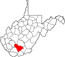
| County | Raleigh |
| Elevation | 1,001 ft (305 m) |
| Time zone | Eastern (EST) (UTC-5) |
| • Summer (DST) | EDT (UTC-4) |
| ZIP code | 25060 |
| Area code(s) | 304 & 681 |
| GNIS feature ID | 1538274[1] |
Dorothy is an unincorporated community in Raleigh County, West Virginia, United States. Dorothy is 4.5 miles (7.2 km) east-southeast of Whitesville. Dorothy has a post office with ZIP code 25060.[2] At one time, it was also called Lawson[3]
References
This article is issued from Wikipedia - version of the 7/28/2016. The text is available under the Creative Commons Attribution/Share Alike but additional terms may apply for the media files.