Dorchester Bay (Boston Harbor)
| Dorchester Bay | |
| Water | |
 Looking northwest from Quincy toward Boston across Dorchester Bay | |
| Country | United States |
|---|---|
| State | Massachusetts |
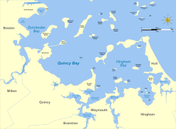 Dorchester Bay, upper left, and nearby features
| |
Dorchester Bay is the smallest of the three smaller bays of southern Boston Harbor,[1][2] part of Massachusetts Bay and forming the south shoreline of the South Boston neighborhood and northeast shoreline of the Dorchester neighborhood of Boston, as well as the north shore of the city of Quincy in Massachusetts.[3]
The bay is home to Thompson Island, one of the Boston Harbor Islands. The Neponset River empties into Dorchester Bay between south Dorchester and Squantum Point Park in Quincy. The John F. Kennedy Library and Museum is located on the west shore of the bay at the end of the Columbia Point peninsula. Day Boulevard, one of the Massachusetts Department of Conservation and Recreation parkways and part of the Metropolitan Park System of Greater Boston, travels 2.6 miles (4.2 km) along the northern shore of Dorchester Bay,[4] offering panoramic views of the bay and islands.
The waters of Dorchester Bay include Pleasure Bay, Old Harbor, Western Way, Squantum Channel, Savin Hill Cove, and Dorchester Bay Basin.
References
- ↑ "Through the Eyes of a Mariner: Touring the Port of Boston". Massachusetts Office of Coastal Zone Management. Retrieved October 12, 2006.
- ↑ The Boston Harbor Association
- ↑ "Boston Harbor and Approaches." Coast Pilot 1 - 39th Edition, 2009. NOAA Office of Coast Survey. 39th Edition. September, 2009.
- ↑ "Datalayers/GIS Database". Massachusetts Executive Office of Energy & Environmental Affairs. Retrieved 2009-07-16.
Coordinates: 42°18′50″N 71°1′33″W / 42.31389°N 71.02583°W