Dooly County, Georgia
| Dooly County, Georgia | |
|---|---|
.JPG) Dooly County Courthouse in Vienna | |
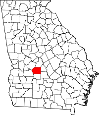 Location in the U.S. state of Georgia | |
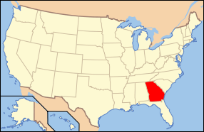 Georgia's location in the U.S. | |
| Founded | May 15, 1821 |
| Named for | John Dooly |
| Seat | Vienna |
| Largest city | Vienna |
| Area | |
| • Total | 397 sq mi (1,028 km2) |
| • Land | 392 sq mi (1,015 km2) |
| • Water | 5.3 sq mi (14 km2), 1.3% |
| Population | |
| • (2010) | 14,918 |
| • Density | 38/sq mi (15/km²) |
| Congressional district | 2nd |
| Time zone | Eastern: UTC-5/-4 |
| Website |
doolycountyga |
Dooly County is a county located in the central portion of the U.S. state of Georgia. As of the 2010 census, the population was 14,918.[1] The county seat is Vienna.[2] The county was created by an act of the Georgia General Assembly on May 15, 1821 and named for Colonel John Dooly,[3] a Georgia American revolutionary war fighter. It was one of the original landlot counties created from land ceded from the Creek Nation.
The entire county of Crisp and parts of Macon, Pulaski, Turner, Wilcox and Worth counties were formed from Dooly's original borders.
Geography
According to the U.S. Census Bureau, the county has a total area of 397 square miles (1,030 km2), of which 392 square miles (1,020 km2) is land and 5.3 square miles (14 km2) (1.3%) is water.[4]
The western two-thirds of Dooly County, from west of Unadilla south to Pinehurst, then to the southeastern corner of the county, is located in the Middle Flint River sub-basin of the ACF River Basin (Apalachicola-Chattahoochee-Flint River Basin). The northeastern and eastern portion of Dooly County is located in the Lower Ocmulgee River sub-basin of the Altamaha River basin. The very southeastern corner of the county is located in the Alapaha River sub-basin of the Suwannee River basin.[5]
Major highways
-
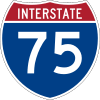 Interstate 75
 -
 U.S. Route 41
 -
 State Route 7
 -
 State Route 27
 -
 State Route 90
 -
 State Route 215
 -
 State Route 230
 -
 State Route 230 Connector
 -
 State Route 257
 -
 State Route 329
 -
 State Route 401 (unsigned designation for I-75)
Adjacent counties
- Houston County - northeast
- Pulaski County - east
- Wilcox County - southeast
- Crisp County - south
- Sumter County - west
- Macon County - northwest
Demographics
| Historical population | |||
|---|---|---|---|
| Census | Pop. | %± | |
| 1830 | 2,135 | — | |
| 1840 | 4,427 | 107.4% | |
| 1850 | 8,361 | 88.9% | |
| 1860 | 8,917 | 6.6% | |
| 1870 | 9,790 | 9.8% | |
| 1880 | 12,420 | 26.9% | |
| 1890 | 18,146 | 46.1% | |
| 1900 | 26,567 | 46.4% | |
| 1910 | 20,554 | −22.6% | |
| 1920 | 20,522 | −0.2% | |
| 1930 | 18,025 | −12.2% | |
| 1940 | 16,886 | −6.3% | |
| 1950 | 14,159 | −16.1% | |
| 1960 | 11,474 | −19.0% | |
| 1970 | 10,404 | −9.3% | |
| 1980 | 10,826 | 4.1% | |
| 1990 | 9,901 | −8.5% | |
| 2000 | 11,525 | 16.4% | |
| 2010 | 14,918 | 29.4% | |
| Est. 2015 | 14,035 | [6] | −5.9% |
| U.S. Decennial Census[7] 1790-1960[8] 1900-1990[9] 1990-2000[10] 2010-2013[1] | |||
2000 census
As of the census[11] of 2000, there were 11,525 people, 3,909 households, and 2,767 families residing in the county. The population density was 29 people per square mile (11/km²). There were 4,499 housing units at an average density of 12 per square mile (4/km²). The racial makeup of the county was 45.97% White, 49.54% Black or African American, 0.16% Native American, 0.43% Asian, 0.11% Pacific Islander, 2.88% from other races, and 0.91% from two or more races. 4.66% of the population were Hispanic or Latino of any race.
There were 3,909 households out of which 33.60% had children under the age of 18 living with them, 45.10% were married couples living together, 20.50% had a female householder with no husband present, and 29.20% were non-families. 25.90% of all households were made up of individuals and 11.40% had someone living alone who was 65 years of age or older. The average household size was 2.62 and the average family size was 3.14.
In the county the population was spread out with 25.60% under the age of 18, 10.30% from 18 to 24, 29.80% from 25 to 44, 22.50% from 45 to 64, and 11.80% who were 65 years of age or older. The median age was 35 years. For every 100 females there were 109.50 males. For every 100 females age 18 and over, there were 111.70 males.
The median income for a household in the county was $27,980, and the median income for a family was $35,337. Males had a median income of $26,670 versus $19,076 for females. The per capita income for the county was $13,628. About 18.00% of families and 22.10% of the population were below the poverty line, including 29.50% of those under age 18 and 21.20% of those age 65 or over.
2010 census
As of the 2010 United States Census, there were 14,918 people, 5,286 households, and 3,576 families residing in the county.[12] The population density was 38.1 inhabitants per square mile (14.7/km2). There were 6,328 housing units at an average density of 16.1 per square mile (6.2/km2).[13] The racial makeup of the county was 49.9% black or African American, 45.6% white, 0.6% Asian, 0.1% American Indian, 2.8% from other races, and 0.9% from two or more races. Those of Hispanic or Latino origin made up 5.8% of the population.[12] In terms of ancestry, 8.9% were American, and 8.7% were English.[14]
Of the 5,286 households, 31.3% had children under the age of 18 living with them, 43.2% were married couples living together, 19.1% had a female householder with no husband present, 32.3% were non-families, and 28.8% of all households were made up of individuals. The average household size was 2.45 and the average family size was 2.99. The median age was 40.0 years.[12]
The median income for a household in the county was $31,038 and the median income for a family was $39,622. Males had a median income of $36,344 versus $27,557 for females. The per capita income for the county was $14,871. About 21.0% of families and 27.1% of the population were below the poverty line, including 41.9% of those under age 18 and 22.3% of those age 65 or over.[15]
Economy
The Big Pig Jig, Georgia's official State Barbecue Cooking Championship, is held annually in Fall in Dooly County and attracts a national audience. The county is also notable for cotton and peanut production.
Education
Dooly County Elementary School Dooly County Middle school Dooly County High School http://www.dooly.k12.ga.us/
Private Schools
- Fullington Academy http://www.fullingtonacademy.com/
Communities
Notable people
- Rooney L. Bowen, Georgia businessman and politician
- George Busbee, governor of Georgia
- Walter F. George, U.S. Senator
- Jody Powell, press secretary and aide to Jimmy Carter
- Roger Kingdom, Olympic gold medalist in track and field
- David Ragan, NASCAR driver
- Keith Mumphery, NFL player
See also
References
- 1 2 "State & County QuickFacts". United States Census Bureau. Retrieved February 15, 2014.
- ↑ "Find a County". National Association of Counties. Retrieved 2011-06-07.
- ↑ Gannett, Henry (1905). The Origin of Certain Place Names in the United States. Govt. Print. Off. p. 108.
- ↑ "US Gazetteer files: 2010, 2000, and 1990". United States Census Bureau. 2011-02-12. Retrieved 2011-04-23.
- ↑ "Georgia Soil and Water Conservation Commission Interactive Mapping Experience". Georgia Soil and Water Conservation Commission. Retrieved 2015-11-24.
- ↑ "County Totals Dataset: Population, Population Change and Estimated Components of Population Change: April 1, 2010 to July 1, 2015". Retrieved July 2, 2016.
- ↑ "U.S. Decennial Census". United States Census Bureau. Retrieved June 22, 2014.
- ↑ "Historical Census Browser". University of Virginia Library. Retrieved June 22, 2014.
- ↑ "Population of Counties by Decennial Census: 1900 to 1990". United States Census Bureau. Retrieved June 22, 2014.
- ↑ "Census 2000 PHC-T-4. Ranking Tables for Counties: 1990 and 2000" (PDF). United States Census Bureau. Retrieved June 22, 2014.
- ↑ "American FactFinder". United States Census Bureau. Retrieved 2011-05-14.
- 1 2 3 "DP-1 Profile of General Population and Housing Characteristics: 2010 Demographic Profile Data". United States Census Bureau. Retrieved 2015-12-29.
- ↑ "Population, Housing Units, Area, and Density: 2010 - County". United States Census Bureau. Retrieved 2015-12-29.
- ↑ "DP02 SELECTED SOCIAL CHARACTERISTICS IN THE UNITED STATES – 2006-2010 American Community Survey 5-Year Estimates". United States Census Bureau. Retrieved 2015-12-29.
- ↑ "DP03 SELECTED ECONOMIC CHARACTERISTICS – 2006-2010 American Community Survey 5-Year Estimates". United States Census Bureau. Retrieved 2015-12-29.
External links
- Georgia.gov Dooly County history
- GeorgiaInfo Dooly County Courthouse info
- Dooly County historical marker
 |
Macon County | Houston County | | |
| Sumter County | |
Pulaski County | ||
| ||||
| | ||||
| Crisp County | Wilcox County |
Municipalities and communities of Dooly County, Georgia, United States | ||
|---|---|---|
| Cities | | |
| Towns | ||
Coordinates: 32°10′N 83°48′W / 32.16°N 83.80°W