EV6 The Rivers Route

EuroVelo 6 (EV6), named The Rivers Route, is a EuroVelo long-distance cycling route running 3,653 km (2,270 mi) along the courses of some of Europe's major rivers — much of the Loire, some of the Saône, a short section of the upper Rhine and almost the entire length of Europe’s second longest river, the Danube — all the way from the Atlantic coast of France to the city of Constanța on the Black Sea.
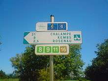
All in all, the EV6 passes through 10 countries from Saint-Nazaire in France at the mouth of the River Loire, eastward along Loire to the River Saône, across the border to Switzerland and then along the Rhine to Lake Constance, north into Germany, then down the River Danube through Austria, Slovakia, Hungary, Serbia, Croatia, Bulgaria, and Romania to the Danube Delta, before heading south to end at the city of Constanța on the Black Sea.
The EV6 includes the Danube Bike Path, the most popular holiday cycle route in Europe.[1] This section stretches from Donaueschingen to Passau in Germany, through Austria to Vienna, and continues on to Novi Sad and Belgrade in Serbia, to Bratislava in Slovakia, before continuing on towards the Danube Delta.[2]
EV6 Loire section
The EV6 runs from Saint-Nazaire at the mouth of the Loire on the Atlantic coast of France, to Nantes, Tours, Blois and travels along the river eastward to Orléans and Nevers before leaving the Loire at Digoin for the Canal du Centre.
EV6 Loire to Basel section
From the Loire, the EV6 follows the Canal du Centre to the River Saône at Chalon-sur-Saône. It continues through Burgundy nearby to the grands crus vineyards through Besançon, Baume-les-Dames, Montbéliard, and to Mulhouse in the Upper Alsace. It then leaves France and crosses into Switzerland at Basel from where it follows the Rhine Valley to Lake Constance before crossing into Germany.
EV6 Danube section - The Danube Bike Path
From Tuttlingen in Germany, the EV6 follows the Danube Bike Path all the way to the Black Sea — though the Danube Bike Path actually starts a bit further upstream from Tuttlingen in Donaueschingen. The Danube Bike Path passes through Germany, Austria, Slovakia, Hungary, Croatia, Serbia, Romania, Bulgaria and the Ukraine.
In the local languages along the way the EV6's Danube Bike Path is known as:
- German: Donauradweg
- Croatian: Dunavska biciklistička ruta
- Slovak: Dunajská cyklistická cesta
- Hungarian: Duna menti kerékpárút
- Serbian: Дунавска бициклистичка рута
- Bulgarian: Дунавски велосипеден път
It usually runs along both sides of the Danube, though sometimes it runs only along one side so that you must cross the Danube a number of times during the course of the route. The Danube flows through very diverse landscapes, including mountainous terrain and passes through a few nature reserves. The route has added appeal through the many mountains, famous towns and monasteries, artistic buildings and geological features. Where the current crosses great plains, the bike path often runs along high water dams with spectacular views, beginning in Lower Bavarian, northern Austria (e.g. Marchfeld) and finally in Hungary.
EV6 in Germany
From Lake Constance, the EV6 follows a route known as the Hohenzollern Route to Tuttlingen where it joins the Danube Bike Path. The rest of the EV6, all the way to the Black Sea, is one and the same as the Danube Bike Path, which in Germany is synonymous with the German Cycling Network's R6 Donauroute (Danube route).
(n.b. the Danube Bike Path / R6 actually starts further upstream from Tuttlingen at Donaueschingen. Guidebooks for the R6 route from Donaueschingen to Passau are available from "BikeLine" in German and English.)
The EV6 route passes through two German states, Baden-Württemberg and Bavaria, and goes through the following route:
- In Baden-Württemberg:
- Hohenzollern Route: Lake Constance ↔ Messkirch ↔ Tuttlingen
- Danube Bike Path: Tuttlingen ↔ Beuron ↔ Sigmaringen ↔ Scheer ↔ Riedlingen ↔ Obermarchtal ↔ Ehingen ↔ Ulm
- In Bavaria:
- Danube Bike Path: Neu-Ulm ↔ Oberelchingen ↔ Leipheim ↔ Günzburg ↔ Offingen ↔ Gundelfingen an der Donau ↔ Lauingen (Donau) ↔ Dillingen an der Donau ↔ Höchstädt an der Donau ↔ Donauwörth ↔ Marxheim ↔ Bertoldsheim ↔ Neuburg an der Donau ↔ Ingolstadt ↔ Neustadt an der Donau ↔ Kloster Weltenburg ↔ Kelheim ↔ Bad Abbach ↔ Regensburg ↔ Donaustauf ↔ Wörth an der Donau ↔ Kössnach ↔ Straubing ↔ Bogen ↔ Mariaposching ↔ Metten ↔ Deggendorf ↔ Niederalteich ↔ Osterhofen ↔ Pleinting ↔ Vilshofen ↔ Windorf ↔ Gaishofen ↔ Passau ↔ Obernzell
The EV6 / Danube Bike Path follows the rail corridor of the Donautalbahn (Danube Valley train) for long stretches — except in the region of the 5 train tunnels (Bahntunnel) that run between Donaueschingen and Ulm — so this offers the possibility to have a mix of journeys by train as well as by bike.
The section in the Upper Danube valley (Oberen Donautal), which runs between the towns Mühlheim an der Donau and Scheer, is the heart of the Upper Danube Nature Reserve (Naturparks Obere Donau) and borders on a great number of chalk cliffs as well as numerous mountains, castles, ruins, monasteries and Baroque churches, including:
- Schloss der Herren von Enzberg in Mühlheim
- Burgruine Kallenberg
- Schloss Bronnen
- Knopfmacherfelsen
- Benediktinerkloster Beuron
- Petershöhle
- Benediktushöhle
- Burg Wildenstein
- Schloss Werenwag
- Burgruine Falkenstein
- Ruine Dietfurt
- Burgruine Neugutenstein
- Amalienfelsen
- Hohenzollernschloss Sigmaringen
- Schloss Scheer
- Schloss Bartelstein
- Barockkirche des Residenzstädtchens Scheer
From Scheer, the Danube leaves the Swabian alps and so the EV6 runs through the wide plains of the upper Swabian Danube valley. The route heads towards Ulm via Riedlingen, Obermarchtal and Ehingen, then leaves Baden-Württemberg and enters Bavaria.
The route goes to Passau via Höchstädt, Donauwörth, Ingolstadt, the Weltenburg monastery, Kelheim, Regensburg, Straubing, Plattling and Vilshofen an der Donau. From Passau both the Danube and the route cross the border into Austria. After Obernzell a ferry offers the possibility to combine the border crossing with the river crossing.
EV6 in Austria

The northern Austrian section runs alongside the R1 Danube route while the southern Austrian section follows the R6 Danube route. In this section, there are paved paths for all but 100 meters on both the north and south banks with bridges, ferries and some dams linking the two banks.
After the Lake Constance Route, the part from Passau to Vienna is the second most used bicycle route in Europe. About 630,000 people use the Austrian part of the EV6, and some 55,000 bikers do the whole 326 kilometres. The ADFC, which also analyses the traffic in the Austrian section since 2010, says that there was an increase compared to previous years.[3] The route is typically travelled from west to east as it is down-hill with winds typically from the west. All along the way you will find delightful small towns, placid scenery, castles on the hills, monasteries, and excursions into woods and farm country.
Downstream from Passau, you can choose to take the path south or north of the Danube. Southside it is recommended to visit the Schardenberg which has a platform that allows you to have an incredible sight over the foothills of the Alps. You may also pass some castles, as for example the Burg Krempelstein or the Burg Vichtenstein.
On this way you will get directly to the Upper Austrian capital city Linz (European Capital of Culture 2009) with its three Danube bridges. The Lentos Art Museum, the Ars Electronica Center, the Brucknerhaus, the Tabakfabrik and the nearby Old Town with its pedestrian area and the cathedral can be found along the redesigned riverside promenade. This part of Linz is characterized by its modern art, including artwork from David Rabinowitch, Mathias Goeritz and Herbert Bayer. If you continue your journey on the Danube route, you’ll arrive at a flood dyke that offers a good sight of the VÖEST industrial estate and the pilgrimage church on the Pöstlingberg.
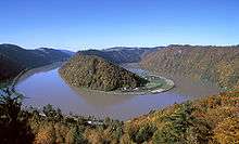
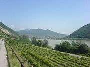
One of the most scenic areas in Upper Austria can be found at the Donauschlinge Schlögen (a hairpin bend in the Danube, a double twist where the river changes its direction about 180°), in the Strudengau and on the north or "left" bank of the Danube river in the Wachau valley, which is a UNESCO World Heritage site. The KZ Mauthausen or the old Roman City Lauriacum are not only interesting but also historically important sights you may pass on your journey. After the village Mitterkirchen and the Stift Ardagger comes the city Grein, which is known for its old Theatre and its castle, Schloss Greinburg.
Through the Vienna Basin, past the Devín Gate, the EV6 Rivers Route continues in Slovakia.
EV6 from Vienna to Budapest
Part III begins in Vienna goes through Bratislava in Slovakia and continues 306 km (190 mi) to Budapest in Hungary.
EV6 from Budapest to the Black Sea
Part IV of the path begins in Budapest and continues 1,670 km (1,040 mi) to the Black Sea in Romania. In this section it passes through Hungary, Serbia, Bulgaria (where it passes the UNESCO Heritage site Srebarna Nature Reserve) then into Romania to the UNESCO Heritage site of the Danube Delta, before following the Black Sea coast to end at Constanța in Romania.
While the EV6 signposted in Serbia, signposts are lacking in much of the route through Bulgaria and Romania. There the route mostly follows streets; cyclists are advised to follow the allocated route.
Gallery
|


See also
| Wikimedia Commons has media related to EuroVelo 6. |
References
- ↑ John Higginson. The Danube Cycleway - Donaueschingen to Budapest. Cicerone.
- ↑ EuroVelo 6, in Deutsch and French and English
- ↑ "'Die ADFC-Radreiseanalyse 2013 – Zahlen, Daten und Fakten" (in German). Retrieved 2014-02-01.
External links
- Official website
- Homeward bound: Returning to Bucharest along EuroVelo 6
- Cycle Touring the Danube River in Austria
- The Danube Cycleway - Donaueschingen to Budapest by John Higginson
- "Danube Bike Trail" maps series from Esterbauer
Coordinates: 48°24′03″N 9°59′14″E / 48.4008°N 9.9872°E