Domart-en-Ponthieu
| Domart-en-Ponthieu | |
|---|---|
 | |
 Domart-en-Ponthieu | |
|
Location within Hauts-de-France region  Domart-en-Ponthieu | |
| Coordinates: 50°04′31″N 2°07′34″E / 50.0753°N 2.1261°ECoordinates: 50°04′31″N 2°07′34″E / 50.0753°N 2.1261°E | |
| Country | France |
| Region | Hauts-de-France |
| Department | Somme |
| Arrondissement | Amiens |
| Canton | Domart-en-Ponthieu |
| Intercommunality | Val de Nièvre et environs |
| Government | |
| • Mayor (2001–2008) | Jean-Luc Hermel |
| Area1 | 17.93 km2 (6.92 sq mi) |
| Population (2006)2 | 1,169 |
| • Density | 65/km2 (170/sq mi) |
| Time zone | CET (UTC+1) |
| • Summer (DST) | CEST (UTC+2) |
| INSEE/Postal code | 80241 / 80620 |
| Elevation |
32–132 m (105–433 ft) (avg. 44 m or 144 ft) |
|
1 French Land Register data, which excludes lakes, ponds, glaciers > 1 km² (0.386 sq mi or 247 acres) and river estuaries. 2 Population without double counting: residents of multiple communes (e.g., students and military personnel) only counted once. | |
Domart-en-Ponthieu is a commune in the Somme department in Hauts-de-France in northern France.
Geography
The commune is situated on the D216 road, some 14 miles (23 km) southeast of Abbeville.
Population
| Year | 1962 | 1968 | 1975 | 1982 | 1990 | 1999 | 2006 |
|---|---|---|---|---|---|---|---|
| Population | 1336 | 1150 | 1152 | 1175 | 1107 | 1126 | 1169 |
| From the year 1962 on: No double counting—residents of multiple communes (e.g. students and military personnel) are counted only once. | |||||||
.jpg)
The church in its verdant setting

The war memorial
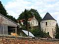
Places of interest
- The Templars house
- The round tower (remains of the château)
- Church
- The war memorial
 The round tower
_1.jpg) The church tower
The church tower_1.jpg) The cemetery gate
The cemetery gate
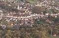
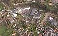
- Aerial views

See also
References
External links
| Wikimedia Commons has media related to Domart-en-Ponthieu. |
This article is issued from Wikipedia - version of the 11/8/2016. The text is available under the Creative Commons Attribution/Share Alike but additional terms may apply for the media files.