Dolores River Bridge
| Dolores River Bridge | |
|---|---|
 | |
| Coordinates | 38°18′30″N 108°52′54″W / 38.30833°N 108.88167°WCoordinates: 38°18′30″N 108°52′54″W / 38.30833°N 108.88167°W |
| Carries |
|
| Crosses | Dolores River |
| Locale | near Bedrock, Colorado |
| Characteristics | |
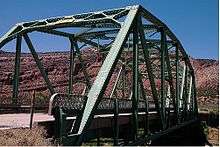
| Design | through truss |
| Total length | 125 ft (38.1 m) |
| Width | 23.9 ft (7.3 m) |
| Longest span | 128.9 ft (39.3 m) |
| Clearance above | 15.6 m (51.2 ft) |
| History | |
| Construction end | 1952 |
| Opened | 1952 |
| Statistics | |
| Daily traffic | 319 (as of 2003) |
|
Dolores River Bridge | |
| NRHP Reference # | 02001150[1] |
| Added to NRHP | October 15, 2002 |
The Dolores River Bridge is a through truss bridge spanning the Dolores River near Bedrock, Colorado. It carries State Highway 90 and is listed on the National Register of Historic Places (reference number 02001150[1]).
References
- 1 2 National Park Service (2006-03-15). "National Register Information System". National Register of Historic Places. National Park Service.
This article is issued from Wikipedia - version of the 11/17/2016. The text is available under the Creative Commons Attribution/Share Alike but additional terms may apply for the media files.