Dollart
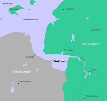
The Dollart (German name) or Dollard (Dutch name) is a bay in the Wadden Sea between the northern Netherlands and Germany, on the west side of the estuary of the Ems river. Most of it dries at low tide. Many water birds feed there.
Gaining from and losing to the sea
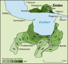
The Dollart Bay was probably created in the 15th century, caused by rising water levels, sinking land surfaces, storm surges and civil strife. Though the land was protected by dikes, feuds between the main Schieringer and Vetkoper parties were detrimental for community efforts. As a result, dike maintenance was neglected and sluices were destroyed. From 1413 onward the sea overflowed the district of (Reiderland) and large parts of the Oldambt district. By 1520 the Dollart had its largest extension. Between the 16th and the 20th centuries, two third of drowned area have been reclaimed again.
Nowadays the unembanked forelands have been declared world natural heritage. They are a paradise for all kinds of birds and other aquatic species. The organisation for landscape protection in Groningen Groningen, Het Groninger Landschap, offers excursions into the Dollart area about three times a year.
Border conflict

The Netherlands and Germany do not agree on the exact course of the border through the bay. The territorial dispute has gained relevance as there are plans for the Borkum Riffgat offshore wind farm.[1]
Literature
- K. Essink (ed.), Stormvloed 1509. Geschiedenis van de Dollard, Groningen: Stichting Verdronken Geschiedenis 2013 (online)
- O.S. Knottnerus, 'Reclamations and submerged lands in the Ems River Estuary (900-1500)'. In: Erik Thoen et al. (eds.), Landscapes or seascapes?. The history of the coastal environment in the North Sea area reconsidered, Turnhout 2013, S. 241-266.
- Gozewinus Acker Stratingh und G.A. Venema, De Dollard of geschied,- aardrijks- en natuurkundige beschrijving van dezen boezem der Eems, Groningen 1855, repr. 1979
- Frank Westerman: De graanrepubliek. Atlas, Amsterdam/Antwerpen 1999, erweitert 2009. [Deutsche Ausgabe Das Getreideparadies. Ch. Links, Berlin 2009, ISBN 978-3-86153-550-8.]
References
- ↑ "Nederland en Duitsland bespreken zeegrens", Spits, 14 January 2011.
External links
-
 Media related to Dollard at Wikimedia Commons
Template:Appendices
Coordinates: 53°17′N 7°10′E / 53.29°N 7.16°E
Bays and former bays on the East Frisian Peninsula | ||
|---|---|---|
|  | |