Dobrovo
| Dobrovo | |
|---|---|
 | |
 Dobrovo Location in Slovenia | |
| Coordinates: 45°59′56.14″N 13°31′46.6″E / 45.9989278°N 13.529611°ECoordinates: 45°59′56.14″N 13°31′46.6″E / 45.9989278°N 13.529611°E | |
| Country |
|
| Traditional region | Slovenian Littoral |
| Statistical region | Gorizia |
| Municipality | Brda |
| Area | |
| • Total | 1.16 km2 (0.45 sq mi) |
| Elevation[1] | 115 m (377 ft) |
| Population (2012)[2] | |
| • Total | 351 |
| • Density | 301/km2 (780/sq mi) |
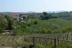
Dobrovo (pronounced [ˈdoːbɾɔʋɔ]; Italian: Castel Dobra) is a settlement the Littoral region of Slovenia, close to the border with Italy. It is the administrative centre of the Municipality of Brda.[3] It lies on the road that connects the Friuli Plain and the Soča Valley.
Dobrovo Castle is a castle in the settlement built around 1600 on the foundations of an older structure. It is an almost perfect square in plan with square turrets on each corner. It houses an art gallery and a museum.[4] The castle chapel is dedicated to Saint Anthony of Padua and belongs to the Parish of Biljana.[5]
References
- ↑ "Nadmorska višina naselij, kjer so sedeži občin" [Height above sea level of seats of municipalities] (in Slovenian and English). Statistical Office of the Republic of Slovenia. 2002.
- ↑ "Dobrovo, Brda". Place Names. Statistical Office of the Republic of Slovenia. Retrieved 6 September 2012.
- ↑ Brda municipal site
- ↑ Slovenian Tourist Board site
- ↑ Koper Diocese list of churches
External links
| Settlements | Administrative centre: Dobrovo
|  |
|---|---|---|
| Landmarks |
| |
| Notable people |
| |
This article is issued from Wikipedia - version of the 12/28/2015. The text is available under the Creative Commons Attribution/Share Alike but additional terms may apply for the media files.