Dniprodzerzhynsk Reservoir
| Dniprodzerzhynsk Reservoir | |
|---|---|
 Landsat satellite photo | |
| Location | Kamianske (to the south), Poltava, Kirovohrad and Dnipropetrovsk Oblasts, Ukraine |
| Coordinates | 48°48′N 34°06′E / 48.800°N 34.100°ECoordinates: 48°48′N 34°06′E / 48.800°N 34.100°E |
| Type | Hydroelectric reservoir |
| Primary inflows | Dnieper River |
| Primary outflows | Dnieper River |
| Catchment area | 567 km2 |
| Basin countries | Russia, Belarus, Ukraine |
| Max. length | 114 km |
| Max. width | 8 km |
| Surface area | 567 km² |
| Max. depth | 15 m |
| Water volume | 2.45 km³ |
| Surface elevation | 104 m |
The Dniprodzerzhynsk Reservoir (Ukrainian: Дніпродзержинське водосховище, Dniprodzerzhyns'ke vodoskhovyshche) is a water reservoir located on the lower part of the Dnieper River in Ukraine. Named after the former name of the city of Kamianske (on 19 May 2016 the Ukrainian parliament voted to rename the city of Dniprodzerzhynsk into Kamianske to comply with decommunization laws[1]), it covers a total area of 567 square kilometres within the Dnipropetrovsk Oblast. It was formed in 1963-1965. The reservoir is mainly used for generating hydroelectric power, transportation, fish farming, and human consumption
The reservoir is 114 km in length, 5 km in width (8 km max.); has a depth of 15 meters, and a volume of 2.45 km³. During winter, the reservoir freezes over.
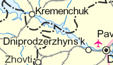
The ports of Kremenchuk and the Dnieper Mineral Enrichment Complex in Horishni Plavni are located on the reservoir. The Dniprodzerzhynsk Hydroelectric Station, constructed during 1956–1965, is also located on the reservoir.
| Tributaries1 | 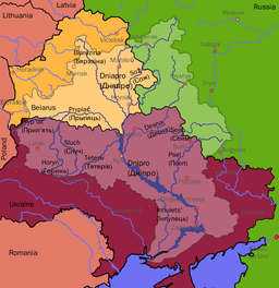 | |
|---|---|---|
| Reservoirs |
| |
| Hydroelectric stations | ||
| Canals |
| |
| Cities | ||
1 Italics indicate left tributaries | ||
References
- ↑ "Рада перейменувала Дніпродзержинськ на Кам'янське" (in Ukrainian). Українські Національні Новини. 19 May 2016. Retrieved 19 May 2016.
Poroshenko signs laws on denouncing Communist, Nazi regimes, Interfax-Ukraine. 15 May 20
Goodbye, Lenin: Ukraine moves to ban communist symbols, BBC News (14 April 2015)