Division of Shortland
| Shortland Australian House of Representatives Division | |
|---|---|
|
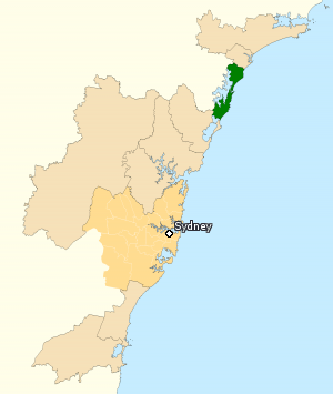
Division of Shortland in New South Wales, as of the 2016 federal election. | |
| Created | 1949 |
| MP | Pat Conroy |
| Party | Labor |
| Namesake | John Shortland |
| Electors | 110,159 (2016) |
| Area | 265 km2 (102.3 sq mi) |
| Demographic | Provincial |
The Division of Shortland is an Australian electoral division in the state of New South Wales. The division is named after Lt John Shortland, an early explorer of the Hunter Region, and was proclaimed at the redistribution of 11 May 1949, and was first contested at the 1949 federal election.
The division closely follows the west coast of the Tasman Sea, on average extending only 5 or 10 kilometres (3.1 or 6.2 mi) inland. Much of the western boundary is formed by Lake Macquarie. The division stretches from Charlestown in the north to Norah Head in the south, and also includes the towns of Toukley, Doyalson, Swansea, Belmont and Gateshead.
The current Member for Shortland, since the 2016 federal election, is Pat Conroy, a member of the Australian Labor Party.
The seat has been held by Labor for its entire existence, and for most of that time has been fairly safe for that party. The Hunter Region is one of the few country areas where Labor consistently does well, and Shortland is no exception; Labor has never tallied less than 57 per cent of the two-party vote.
Members
| Member | Party | Term | |
|---|---|---|---|
| Charles Griffiths | Labor | 1949–1972 | |
| Peter Morris | Labor | 1972–1998 | |
| Jill Hall | Labor | 1998–2016 | |
| Pat Conroy | Labor | 2016–present | |
Election results
| Party | Candidate | Votes | % | ± | |
|---|---|---|---|---|---|
| Labor | Pat Conroy | 50,164 | 51.17 | +3.00 | |
| Liberal | Jenny Barrie | 34,514 | 35.20 | −1.30 | |
| Greens | Ivan Macfadyen | 9,279 | 9.46 | +3.14 | |
| Christian Democrats | Morgan Cox | 4,081 | 4.16 | +2.59 | |
| Total formal votes | 98,038 | 95.29 | +1.58 | ||
| Informal votes | 4,845 | 4.71 | −1.58 | ||
| Turnout | 102,883 | 93.40 | −2.78 | ||
| Two-party-preferred result | |||||
| Labor | Pat Conroy | 58,761 | 59.94 | +2.54 | |
| Liberal | Jenny Barrie | 39,277 | 40.06 | −2.54 | |
| Labor hold | Swing | +2.54 | |||
References
- ↑ Shortland, NSW, Virtual Tally Room 2016, Australian Electoral Commission.
External links
Coordinates: 33°06′43″S 151°37′01″E / 33.112°S 151.617°E