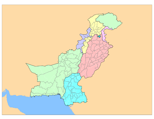
Districts of Pakistan
 |
| This article is part of a series on the politics and government of Pakistan |
| Constitution |
|
The Districts of Pakistan (Urdu: اِضلاعِ پاكِستان), are the third order administrative divisions of Pakistan. Districts are the third order of administrative divisions, below provinces and "divisions". Although the "divisions" were abolished due to the reforms of August 2000, Punjab province restored them back in 2008 followed by Balochistan in 2009, Sindh in 2011 and Khyber Pakhtunkhwa in 2013.[1][2][3][4] Nevertheless, the 149 districts still form the top tier of a three-tier system of local government with the two lower tiers composed of approximately 596 tehsils (included the Kashmir region) and more than 6,000 union councils.
Prior to 2001, there were 106 districts but with the reorganisation, these were reduced to 102 by the merger of the five districts of Karachi Central, Karachi East, Karachi South, Karachi West and Malir to form Karachi District. The five districts had formed the division of Karachi which was abolished. The number of districts rose to 106 again in December 2004, when four new districts were created in the province of Sindh of which one (Umerkot) had existed until 2000 and three districts (Kashmore, Qambar and Jamshoro) were newly created.[5][note 1] The new districts were carved out of Mirpur Khas, Jacobabad, Larkana and Dadu Districts respectively.
In May 2005, the Punjab provincial government created a new district by raising the status of Nankana Sahib from a tehsil of Sheikhupura District to a district in its own right.[6][note 2] On 11 July 2011, the Sindh Government restored again the districts of Karachi South, Karachi East, Malir, Karachi West and Karachi Central, then later in 2013, the district of Korangi was carved out of Karachi East District.
In Azad Kashmir, the second tier of government is formed by three administrative divisions with a third tier of ten districts. In Gilgit–Baltistan, there are nine districts divided between the two regions of Gilgit and Baltistan; Baltistan being a part of Ladakh under Pakistani control, the other part being under Indian control.
Chagai is the largest district of Pakistan by area while Lahore District is the largest by population with total population of 6,318,745 by 1998 census. Quetta is the largest district of Balochistan by population with total population of 744,802 by 1998 census. Bahawalpur is the largest district of Punjab by area. Chitral is the largest by area and Peshawar is the largest by population from Khyber Pakhtunkhwa. Sindh's largest district by area is Thatta and by population its one of the Karachi districts since combined population of six Karachi districts is over 13 millions by 1998 census making average population of these six districts over 2 millions each. South Waziristan Agency and Bajaur Agency are the largest from FATA by area and population respectively while Neelum and Kotli are Azad Kashmir's largest in the same order. Gilgit is the largest by area and population both for Gilgit-Baltistan.
Overview
.jpg)
| Sr. No. | Subdivision | Districts | Area (km²) |
Population (1998) |
Density (people/km²) |
Country of Comparable Size |
|---|---|---|---|---|---|---|
| 1 | Balochistan | 32[7] | 347,190 | 6,566,000 | 18.9 | |
| 2 | Khyber Pakhtunkhwa | 26[8] | 74 521 | 17,744,000 | 238.1 | |
| 3 | Punjab | 36[9] | 205,345 | 73,621,000 | 358.52 | |
| 4 | Sindh | 29[10] | 140,914 | 30,440,000 | 216.02 | |
| 5 | Islamabad Capital Territory | 1 | 906 | 805,000 | 880.8 | |
| 6 | Federally Administered Tribal Areas | 7 tribal agencies 6 frontier regions | 27,220 | 3,176,000 | 116.7 | |
| 7 | Azad Jammu and Kashmir | 10 | 13,297 | 2,972,500 | 258 | |
| 8 | Gilgit-Baltistan | 10 | 72,971 | 3,500,000 | 24.8 |
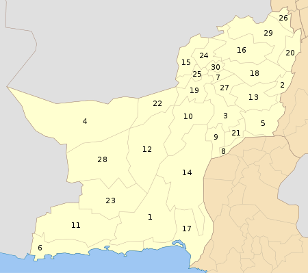
Balochistan
| Sr. No. | District | Headquarters | Area (km²) |
Population (1998) |
Density (people/km²) |
Division | |
|---|---|---|---|---|---|---|---|
 |
1 | Awaran | Awaran | 29,100 | 118,173 | 4 | Kalat |
| 2 | Barkhan | Barkhan | 3,514 | 103,545 | 29 | Zhob | |
| 3 | Kachhi (Bolan) | Dhadar | 7,499 | 288,056 | 38 | Nasirabad | |
| 4 | Chagai | Chagai | 44,748[11] | 300,000 | 7 | Quetta | |
| 5 | Dera Bugti | Dera Bugti | 10,160 | 181,310 | 18 | Sibi | |
| 6 | Gwadar | Gwadar | 12,637 | 185,498 | 15 | Makran | |
| 7 | Harnai[12][note 3] | Harnai | 4,096 | 140,000 | 19 | Sibi | |
| 8 | Jafarabad | Dera Allahyar | 2,445 | 432,817 | 177 | Nasirabad | |
| 9 | Jhal Magsi | Jhal Magsi | 3,615 | 109,941 | 30 | Nasirabad | |
| 10 | Kalat | Kalat | 6,622 | 237,834 | 36 | Kalat | |
| 11 | Kech (Turbat) | Turbat | 22,539 | 413,204 | 18 | Makran | |
| 12 | Kharan | Kharan | 8,958 | 132,500 | 4 | Kalat | |
| 13 | Kohlu | Kohlu | 7,610 | 99,846 | 13 | Sibi | |
| 14 | Khuzdar | Khuzdar | 35,380 | 417,466 | 12 | Kalat | |
| 15 | Killa Abdullah | Killa Abdullah | 3,293 | 370,269 | 112 | Quetta | |
| 16 | Killa Saifullah | Killa Saifullah | 6,831 | 193,553 | 28 | Zhob | |
| 17 | Lasbela | Uthal | 15,153 | 312,695 | 21 | Kalat | |
| 18 | Loralai | Loralai | 9,830 | 295,555 | 30 | Zhob | |
| 19 | Mastung | Mastung | 5,896 | 179,784 | 30 | Kalat | |
| 20 | Musakhel | Musa Khel Bazar | 5,728 | 134,056 | 23 | Zhob | |
| 21 | Nasirabad | Dera Murad Jamali | 3,387 | 245,894 | 73 | Nasirabad | |
| 22 | Nushki[13] | Nushki | 5,797 | 137,500 | 23 | Quetta | |
| 23 | Panjgur | Panjgur | 16,891 | 234,051 | 14 | Makran | |
| 24 | Pishin | Pishin | 7,819 | 367,183 | 47 | Quetta | |
| 25 | Quetta | Quetta | 2,653 | 744,802 | 281 | Quetta | |
| 26 | Sherani[note 4] | Sherani | Zhob | ||||
| 27 | Sibi | Sibi | 7,796 | 180,398 | 23 | Sibi | |
| 28 | Washuk[note 5] | Washuk | 29,510 | 118,171 | 4.0 | Kalat | |
| 29 | Zhob | Zhob | 20,297 | 275,142 | 14 | Zhob | |
| 30 | Ziarat | Ziarat | 1,489 | 33,340 | 22 | Kalat | |
| (31) | Lehri | Bakhtiarabad | 9,830 | 295,555 | 30 | Nasirabad | |
| (32) | Sohbatpur | Sohbatpur | 7,796 | 180,398 | 23 | Nasirabad |
Note: In this map, Lehri is shown within Sibi District on #27. Sohbatpur is shown within Jafarabad District on #8.
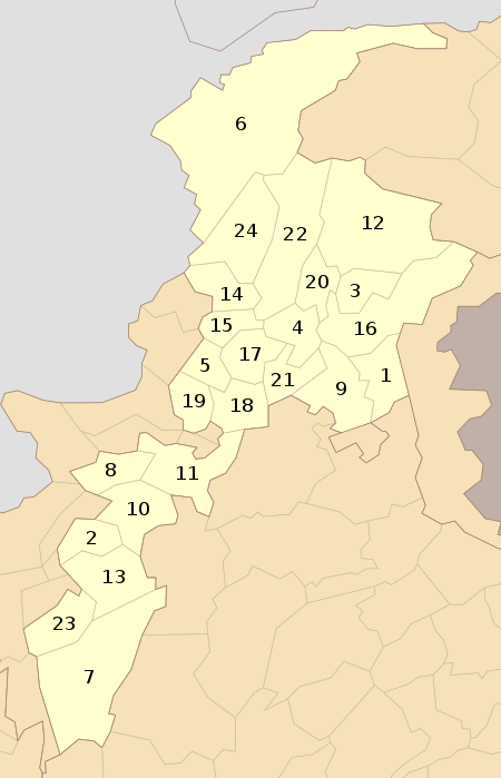
Khyber Pakhtunkhwa (KPK)
| Sr. No. | District | Headquarters | Area (km²) |
Population (1998) |
Density (people/km²) |
Division | |
|---|---|---|---|---|---|---|---|
 | |||||||
| 1 | Abbottabad | Abbottabad | 1,967 | 880,666 | 448 | Hazara | |
| 2 | Bannu | Bannu | 1,227 | 675,667 | 551 | Bannu | |
| 3 | Battagram | Battagram | 1,301 | 307,278 | 236 | Hazara | |
| 4 | Buner | Daggar | 1,865 | 506,048 | 271 | Malakand | |
| 5 | Charsadda | Charsadda | 996 | 1,022,364 | 1,026 | Peshawar | |
| 6 | Chitral | Chitral | 14,850 | 318,689 | 21 | Malakand | |
| 7 | Dera Ismail Khan | Dera Ismail Khan | 7,326 | 852,995 | 116 | Dera Ismail Khan | |
| 8 | Hangu | Hangu | 1,597 | 614,529 | 385 | Kohat | |
| 9 | Haripur | Haripur | 1,725 | 692,228 | 401 | Hazara | |
| 10 | Karak | Karak | 3,372 | 430,796 | 128 | Kohat | |
| 11 | Kohat | Kohat | 2,545 | 562,644 | 221 | Kohat | |
| 12 | Upper Kohistan | Dassu | 7,492 | 472,570 | 63 | Hazara | |
| 13 | Lakki Marwat | Lakki Marwat | 3,164 | 490,025 | 155 | Bannu | |
| 14 | Lower Dir | Timergara | 1,582 | 717,649 | 454 | Malakand | |
| 15 | Malakand | Batkhela | 952 | 452,291 | 475 | Malakand | |
| 16 | Mansehra | Mansehra | 4,579 | 1,152,839 | 252 | Hazara | |
| 17 | Mardan | Mardan | 1,632 | 1,460,100 | 895 | Mardan | |
| 18 | Nowshera | Nowshera | 1,748 | 874,373 | 500 | Peshawar | |
| 19 | Peshawar | Peshawar | 1,257 | 2,019,118 | 1,606 | Peshawar | |
| 20 | Shangla | Alpuri | 1,586 | 434,563 | 274 | Malakand | |
| 21 | Swabi | Swabi | 1,543 | 1,026,804 | 665 | Mardan | |
| 22 | Swat | Saidu Sharif | 5,337 | 1,257,602 | 290 | Malakand | |
| 23 | Tank | Tank | 1,679 | 238,216 | 142 | Dera Ismail Khan | |
| 24 | Upper Dir | Dir | 3,699 | 575,858 | 156 | Malakand | |
| 25 | Tor Ghar | Tor Ghar | 497 | 185,000 | 372 | Hazara | |
| 26 | Lower Kohistan | Pattan | 7,492 | 472,570 | 63 | Hazara |
Note: In this map, the Upper and Lower Kohistan District both are shown as one district on #12 of map. Tor Ghar is shown within Manshera District on #16.
Punjab
| Sr. No. | District | Headquarters | Area (km²) |
Population (1998) |
Density (people/km²) |
Division | |
|---|---|---|---|---|---|---|---|
_Districts.svg.png) | |||||||
| 1 | Attock | Attock | 6,858 | 1,274,935 | 186 | Rawalpindi | |
| 2 | Bahawalnagar | Bahawalnagar | 8,878 | 2,061,447 | 232 | Bahawalpur | |
| 3 | Bahawalpur | Bahawalpur | 24,830 | 2,433,091 | 98 | Bahawalpur | |
| 4 | Bhakkar | Bhakkar | 8,153 | 1,051,456 | 129 | Sargodha | |
| 5 | Chakwal | Chakwal | 6,524 | 1,083,725 | 166 | Rawalpindi | |
| 6 | Chiniot | Chiniot | 965,124 | Faisalabad | |||
| 7 | Dera Ghazi Khan | Dera Ghazi Khan | 11,922 | 2,643,118 | 238 | Dera Ghazi Khan | |
| 8 | Faisalabad | Faisalabad | 5,856 | 5,429,547 | 927 | Faisalabad | |
| 9 | Gujranwala | Gujranwala | 3,622 | 3,400,940 | 939 | Gujranwala | |
| 10 | Gujrat | Gujrat | 3,192 | 2,048,008 | 642 | Gujranwala | |
| 11 | Hafizabad | Hafizabad | 2,367 | 832,980 | 352 | Gujranwala | |
| 12 | Jhang | Jhang | 8,809 | 2,834,546 | 322 | Faisalabad | |
| 13 | Jhelum | Jhelum | 3,587 | 936,957 | 261 | Rawalpindi | |
| 14 | Kasur | Kasur | 4,796 | 1,466,000 | 595 | Lahore | |
| 15 | Khanewal | Khanewal | 4,349 | 2,068,490 | 476 | Multan | |
| 16 | Khushab | Jauharabad | 6,511 | 1,205,460 | 185 | Sargodha | |
| 17 | Lahore | Lahore | 1,772 | 6,318,745 | 3,566 | Lahore | |
| 18 | Layyah | Layyah | 6,291 | 1,120,951 | 178 | Dera Ghazi Khan | |
| 19 | Lodhran | Lodhran | 2,778 | 1,171,800 | 422 | Multan | |
| 20 | Mandi Bahauddin | Mandi Bahauddin | 2,673 | 1,160,552 | 434 | Gujranwala | |
| 21 | Mianwali | Mianwali | 5,840 | 1,056,620 | 181 | Sargodha | |
| 22 | Multan | Multan | 3,720 | 3,116,851 | 838 | Multan | |
| 23 | Muzaffargarh | Muzaffargarh | 8,249 | 2,635,903 | 320 | Dera Ghazi Khan | |
| 24 | Narowal | Narowal | 2,337 | 1,265,097 | 541 | Gujranwala | |
| 25 | Nankana Sahib[6] | Nankana Sahib | 2,960 | 1,410,000 | 476 | Lahore | |
| 26 | Okara | Okara | 3,004 | 2,232,992 | 510 | Sahiwal | |
| 27 | Pakpattan | Pakpattan | 2,724 | 1,286,680 | 472 | Sahiwal | |
| 28 | Rahim Yar Khan | Rahim Yar Khan | 11,880 | 3,141,053 | 264 | Bahawalpur | |
| 29 | Rajanpur | Rajanpur | 12,319 | 1,103,618 | 90 | Dera Ghazi Khan | |
| 30 | Rawalpindi | Rawalpindi | 5,286 | 3,363,911 | 636 | Rawalpindi | |
| 31 | Sahiwal | Sahiwal | 3,201 | 1,843,194 | 576 | Sahiwal | |
| 32 | Sargodha | Sargodha | 5,854 | 2,665,979 | 455 | Sargodha | |
| 33 | Sheikhupura | Sheikhupura | 5,960 | 2,321,029 | 557 | Sheikhupura | |
| 34 | Sialkot | Sialkot | 3,016 | 1,688,823 | 903 | Gujranwala | |
| 35 | Toba Tek Singh | Toba Tek Singh | 3,252 | 1,621,593 | 499 | Faisalabad | |
| 36 | Vehari | Vehari | 4,364 | 2,090,416 | 479 | Multan |
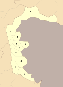
Sindh

Note: In this map, Sujawal is shown within Thatta District on #22.
Federally Administered Tribal Areas
| Sr. No. | District | Headquarters | Area (km²) |
Population (2012) |
Density (people/km²) | |
|---|---|---|---|---|---|---|
 | ||||||
| 1 | Bajaur Agency | Khar | 1,290 | 595,227 | 461 | |
| 2 | Khyber Agency | Landi Kotal | 2,576 | 546,730 | 212 | |
| 3 | Kurram Agency | Parachinar | 3,380 | 448,310 | 133 | |
| 4 | Mohmand Agency | Ghalanai | 2,296 | 334,453 | 146 | |
| 5 | North Waziristan Agency | Miranshah | 4,707 | 361,246 | 77 | |
| 6 | Orakzai Agency | Kalaya | 1,538 | 225,441 | 147 | |
| 7 | South Waziristan Agency | Wana | 6,620 | 429,841 | 65 | |
| 8 | FR Bannu | Bannu | 745 | 19,593 | 26 | |
| 9 | FR Dera Ismail Khan | Dera Ismail Khan | 2,008 | 38,990 | 19 | |
| 10 | FR Kohat | Kohat | 446 | 88,456 | 198 | |
| 11 | FR Lakki Marwat | Lakki Marwat | 132 | 6,987 | 53 | |
| 12 | FR Peshawar | Peshawar | 261 | 53,841 | 206 | |
| 13 | FR Tank | Tank, Pakistan | 1,221 | 27,216 | 22 |
Azad Jammu and Kashmir
| Sr. No. | District | Headquarters | Area (km²) |
Population (1998) |
Density (people/km²) |
Division | |
|---|---|---|---|---|---|---|---|
 | |||||||
| 1 | Muzaffarabad | Muzaffarabad | 2,496 | 615,000 | 375 | Muzaffarabad | |
| 2 | Jhelum valley | Jhelum valley | 854 | 225,000 | 263 | Muzaffarabad | |
| 3 | Neelum | Athmuqam | 3,621 | 171,000 | 47 | Muzaffarabad | |
| 4 | Mirpur | Mirpur | 1,010 | 419,000 | 415 | Mirpur | |
| 5 | Bhimber | Bhimber | 1,516 | 401,000 | 265 | Mirpur | |
| 6 | Kotli | Kotli | 1,862 | 746,000 | 401 | Mirpur | |
| 7 | Poonch | Rawalakot | 855 | 524,000 | 613 | Poonch | |
| 8 | Bagh | Bagh | 770 | 351,000 | 456 | Poonch | |
| 9 | Haveli | Forward Kahuta | 598 | 138,000 | 231 | Poonch | |
| 10 | Sudhnati | Pallandari | 569 | 278,000 | 489 | Poonch |
Gilgit–Baltistan
| Sr. No. | District | Headquarters | Area (km²) |
Population (1998) |
Division | |
|---|---|---|---|---|---|---|
 |
1 | Ghanche | Khaplu | 6,400 | 88,366 | Baltistan |
| 2 | Skardu | Skardu | 15,000 | 214,848 | Baltistan | |
| 3 | Astore | Eidgah | 8,657 | 71,666 | Gilgit | |
| 4 | Diamer | Chilas | 10,936 | 131,925 | Gilgit | |
| 5 | Ghizer | Gakuch | 9,635 | 120,218 | Gilgit | |
| 6 | Gilgit | Gilgit | 38,000 | 243,324 | Gilgit | |
| 7 | Hunza | Ali Abad | 17,145 | 80,355 | Gilgit | |
| 8 | Kharmang | Tolti | 20,000[15] | Baltistan | ||
| 9 | Shigar | Shigar | NA | NA | Baltistan | |
| 10 | Nagar | Nagar II | 15,567 | 89,420 | Gilgit |
See also
Notes
- 1 2 3 4 No data is available on the recently created districts of Sindh Province.
- ↑ No data is available on the recently created district of Nankana, which was part of Sheikhupura District.
- ↑ No data is yet available on the recently created district of Harnai, which was part of Sibi District.
- ↑ No data is yet available on the recently created district of Sherani, which was part of Zhob District.
- ↑ No data is yet available on the recently created district of Washuk, which was part of Kharan District.
All the figures require to be re-checked. Data entry error has occurred in Sindh Province.
References
- ↑ "Dunya News: Pakistan:-In districts of Pakistan the Hangu district is the most sensitive Area and district of Pakistan.Commissionerate system restored in KPK...". dunyanews.tv. Retrieved 9 March 2016.
- ↑ "Commissionerate system restored".
- ↑ "Governor Balochistan notifies restoration of Commissioner System". Aaj News. Retrieved 9 March 2016.
- ↑ "Sindh back to 5 divisions after 11 years".
- ↑ "Four new districts in Sindh". Daily Times. 11 December 2004. Archived from the original on 11 December 2013. Retrieved 16 February 2014.
- 1 2 "Nankana becomes district". Dawn.Com. 10 May 2005. Retrieved 16 February 2014.
- ↑ "Districts". Balochistan.gov.pk. Retrieved 16 February 2014.
- ↑ "Government". Khyberpakhtunkhwa.gov.pk. Retrieved 16 February 2014.
- ↑ "Districts | Punjab Portal". Punjab.gov.pk. 16 January 2014. Retrieved 16 February 2014.
- ↑ "Map of Sindh". Government of Sindh. Retrieved 16 February 2014.
- ↑ "Country escapes major earthquake damage". Daily Times. 20 January 2011. Archived from the original on 11 December 2013. Retrieved 16 February 2014.
- ↑ "Harnai is new district of Balochistan". Dawn.Com. 31 August 2007. Retrieved 16 February 2014.
- ↑ "Kharan and Noshki District" (PDF). American Refugee Committee. July 2007. Retrieved 16 February 2014.
- ↑ "Historically & Geographically". District Government Umerkot. Archived from the original on 24 February 2012. Retrieved 16 February 2014.
- ↑ http://pakobserver.net/201303/24/detailnews.asp?id=201427
Further reading
- Population Census Organization, Government of Pakistan. "List of Districts/Agencies/Tribal Areas". Archived from the original on 19 December 2010. Retrieved 14 April 2006.
- Population Census Organization, Government of Pakistan. "List of Tehsils/Talukas with respect to their Districts". Archived from the original on 30 December 2010. Retrieved 14 April 2006.
- Country Profiles, South Asian Media Net. "Pakistan >> District Profiles". Archived from the original on 18 May 2011. Retrieved 14 April 2006.
- "District Governments of Sindh". Local Government Department, Government of Sindh. Archived from the original on 26 November 2009. Retrieved 16 February 2014.
External links
- List of districts from the Population Census Organization (Government of Pakistan)
| |||||||||||||||||||||||||||||||||
| |||||||||||||||||||||||||||||||||
| |||||||||||||||||||||||||||||||||
| |||||||||||||||||||||||||||||||||
| |||||||||||||||||||||||||||||||||
| |||||||||||||||||||||||||||||||||
| ||||||||||||||||||||||||||||||||||||||||||||||
| ||||||||||||||||||||||||||||||||||||||||||||||
| ||||||||||||||||||||||||||||||||||||||||||||||
| ||||||||||||||||||||||||||||||||||||||||||||||
| ||||||||||||||||||||||||||||||||||||||||||||||
| ||||||||||||||||||||||||||||||||||||||||||||||
| ||||||||||||||||||||||||||||||||||||||||||||||
| ||||||||||||||||||||||||||||||||||||||||||||||