District Heights, Maryland
| District Heights, Maryland | ||
|---|---|---|
| City | ||
| City of District Heights | ||
| ||
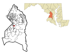 Location of District Heights, Maryland | ||
| Coordinates: 38°51′34″N 76°53′21″W / 38.85944°N 76.88917°WCoordinates: 38°51′34″N 76°53′21″W / 38.85944°N 76.88917°W | ||
| Country |
| |
| State |
| |
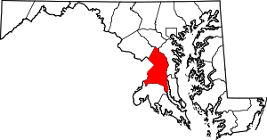
| County |
| |
| Area[1] | ||
| • Total | 0.93 sq mi (2.41 km2) | |
| • Land | 0.93 sq mi (2.41 km2) | |
| • Water | 0 sq mi (0 km2) | |
| Elevation | 266 ft (81 m) | |
| Population (2010)[2] | ||
| • Total | 5,837 | |
| • Estimate (2012[3]) | 5,949 | |
| • Density | 6,276.3/sq mi (2,423.3/km2) | |
| Time zone | Eastern (EST) (UTC-5) | |
| • Summer (DST) | EDT (UTC-4) | |
| ZIP codes | 20747, 20753 | |
| Area code(s) | 301 | |
| FIPS code | 24-23025 | |
| GNIS feature ID | 0597330 | |
| Website | http://www.districtheights.org/ | |
District Heights is an incorporated city in Prince George's County, Maryland, located near Maryland Route 4.[4] The population was 5,837 at the 2010 United States Census. For more information, see the separate articles on Forestville, Maryland and Suitland.
District Heights is 9.85 miles (15.85 km) away from central Washington, D.C.
Geography
District Heights is located at 38°51′34″N 76°53′21″W / 38.85944°N 76.88917°W (38.859545, −76.889139).[5]
According to the United States Census Bureau, the city has a total area of 0.93 square miles (2.41 km2), all of it land.[1]
History
District Heights was originally farm land owned by Major Leander P. Williams, purchased as four patented Lord Baltimore tracts known as: "Good Luck," "Magruder's Plains Enlarged," "the Levels," and "Offutt's Adventure." Under grants issued to Lord Baltimore by King Charles I of Great Britain, the tracts belonged to Colonel Ninian Beall, Benjamin Berry, and Alexander Magruder. District Heights evolved from one of the four patents. In 1925 land purchased and formed into District Heights Company by Joseph Tepper, David L. Blanken, Henry Oxenberg, Gilbert Leventhal, Simon Gordon, and Simon Gerber. The land was farmed by Walter and Al Dustin, whose farmhouse stood at 7116 Foster Street. By 1925 streets laid out first three blocks of Halleck Street and Aztec. By 1936, the city had approximately 25 homes built, two businesses, a grocery store and filling station, a pump house and water tower to furnish the water and pressure for the City, a sewage system and a free Model T bus service to 17th and Pennsylvania Avenue, S.E.
Bordering areas
- Walker Mill (North)
- Forestville (Southeast)
- Capitol Heights (Northwest)
- Morningside (South)
Demographics
| Historical population | |||
|---|---|---|---|
| Census | Pop. | %± | |
| 1940 | 32 | — | |
| 1950 | 1,735 | 5,321.9% | |
| 1960 | 7,524 | 333.7% | |
| 1970 | 7,846 | 4.3% | |
| 1980 | 6,799 | −13.3% | |
| 1990 | 6,704 | −1.4% | |
| 2000 | 5,958 | −11.1% | |
| 2010 | 5,837 | −2.0% | |
| Est. 2015 | 6,144 | [6] | 5.3% |
2010 census
As of the census[2] of 2010, there were 5,837 people, 2,050 households, and 1,505 families residing in the city. The population density was 6,276.3 inhabitants per square mile (2,423.3/km2). There were 2,212 housing units at an average density of 2,378.5 per square mile (918.3/km2). The racial makeup of the city was 6.0% White, 90.1% African American, 0.2% Native American, 0.6% Asian, 1.1% from other races, and 1.9% from two or more races. Hispanic or Latino of any race were 3.7% of the population.
There were 2,050 households of which 40.4% had children under the age of 18 living with them, 35.0% were married couples living together, 32.8% had a female householder with no husband present, 5.7% had a male householder with no wife present, and 26.6% were non-families. 22.5% of all households were made up of individuals and 5.7% had someone living alone who was 65 years of age or older. The average household size was 2.85 and the average family size was 3.31.
The median age in the city was 35.8 years. 26.3% of residents were under the age of 18; 10.9% were between the ages of 18 and 24; 24.5% were from 25 to 44; 28.3% were from 45 to 64; and 10% were 65 years of age or older. The gender makeup of the city was 46.0% male and 54.0% female.
2000 census
As of the census[8] of 2000, there were 5,958 people, 2,070 households, and 1,538 families residing in the city. The population density was 6,649.1 people per square mile (2,556.0/km²). There were 2,170 housing units at an average density of 2,421.7 per square mile (930.9/km²). The racial makeup of the city was 9.20% White, 87.95% African American, 0.12% Native American, 0.86% Asian, 0.20% from other races, and 1.68% from two or more races. Hispanic or Latino of any race were 0.49% of the population.
There were 2,070 households out of which 38.3% had children under the age of 18 living with them, 39.6% were married couples living together, 28.2% had a female householder with no husband present, and 25.7% were non-families. 22.1% of all households were made up of individuals and 5.0% had someone living alone who was 65 years of age or older. The average household size was 2.88 and the average family size was 3.36.
In the city the population was spread out with 30.8% under the age of 18, 8.3% from 18 to 24, 29.3% from 25 to 44, 23.6% from 45 to 64, and 8.0% who were 65 years of age or older. The median age was 34 years. For every 100 females there were 84.9 males. For every 100 females age 18 and over, there were 76.1 males.
The median income for a household in the city was $52,331, and the median income for a family was $61,220. Males had a median income of $37,129 versus $32,443 for females. The per capita income for the city was $21,190. About 4.5% of families and 5.9% of the population were below the poverty line, including 9.0% of those under age 18 and 6.1% of those age 65 or over.
Notable people
- Lloyd R. Woodson, arrested in 2010 with military-grade illegal weapons he intended to use in a violent crime, and a detailed map of the Fort Drum military installation.
- NaVorro Bowman, former outside linebacker at Penn State University and current inside linebacker for the San Francisco 49ers was born and attended high school in Forestville.[9]
- East Coast Rapist, Aaron H. Thomas, lived in District Heights/Forestville from June 1994 to August 2006.
- LaTonya Swann, winner of BET's Born To Dance, was born and raised in District Heights.
Government
The city is governed by a mayor and city commission elected every 4 years.
Current Elected Mayor and City Commission
Mayor Jack C. Sims; Commissioner Eddie Martin (Ward 2); Commissioner Cynthia Miller (Ward 1); Commissioner Johnathan Medlock (Ward 1); Commissioner Harryette Irving (Ward 2)
Law enforcement
The District Heights Police Department (DHPD) is the primary law enforcement agency for the City of District Heights which is located in Prince George's County, Maryland. An agreement exists with Prince George's County Police Department and the Prince George's County Sheriff's Office that outlines mutual aid assistance. Assistance is also provided by neighboring municipal agencies.[10]
Officers serve the City Commission and the citizens who reside in and around the Municipal Corporation of District Heights. District Heights is located within the 3rd District of the Prince George's County Police Department. The two agencies work closely together responding to calls for service as well as solving crimes. Although the crime rate as reported by the Federal Bureau of Investigation is twenty~two percent higher than the national average, this number represents both the non-corporate and corporate portions of District Heights.
The District Heights Police Department began in 1936. Over the years, it has seen many different officers. In 2012, Chief Michael March (Ret) retired, sparking the City Commission to temporarily appoint Chief (Fmr) Yolanda Alexander. Chief Alexander served as acting Chief for more than a year until she was fully sworn in as Chief of Police in October 2013. Her contract as Chief for the District Heights Police Department was not renewed after May 2014 City Mayoral and Commission elections. Several members stated a difference of opinion. The current Chief for the Department, Elliott Gibson, has a long history and experience in law enforcement. He began his career in the 1970s as a police officer for the Washington D.C. Metrolpolitan Police Department.
Education
The city is served by the Prince George's County Public Schools and District 7 of the County's Board of Education.[11]
Elementary schools that serve the city include:
- District Heights Elementary School[12]
- Formerly included District Heights Parkway Elementary, whose building makes up half the current school, and which fed primary grades to District Heights Elementary following 2nd or 3rd grade
- North Forestville Elementary School[13]
Middle schools that serve the city include:
- Andrew Jackson Academy (K-8)[14]
- Drew-Freeman Middle School (7-8)[15]
- Samuel P. Massie Academy (PreK-8)[16]
High schools that serve the city include:
References
- 1 2 "US Gazetteer files 2010". United States Census Bureau. Retrieved 2013-01-25.
- 1 2 "American FactFinder". United States Census Bureau. Retrieved 2013-01-25.
- ↑ "Population Estimates". United States Census Bureau. Retrieved 2013-06-26.
- ↑ U.S. Geological Survey Geographic Names Information System: District Heights, Maryland
- ↑ "US Gazetteer files: 2010, 2000, and 1990". United States Census Bureau. 2011-02-12. Retrieved 2011-04-23.
- ↑ "Annual Estimates of the Resident Population for Incorporated Places: April 1, 2010 to July 1, 2015". Retrieved July 2, 2016.
- ↑ "Census of Population and Housing". Census.gov. Retrieved June 4, 2015.
- ↑ "American FactFinder". United States Census Bureau. Retrieved 2008-01-31.
- ↑ "Navorro Bowman".
- ↑ Demographics
- ↑ "Prince George's County Public Schools Board of Education".
- ↑ http://www.pgcps.org/~dheights
- ↑ http://www.pgcps.org/~nforest
- ↑ http://www1.pgcps.org/andrewjackson/
- ↑ http://www.pgcps.org/~dfreeman
- ↑ http://www1.pgcps.org/samuelpmassie/
- ↑ http://www.pgcps.org/~wise
- ↑ http://www1.pgcps.org/forestville
- ↑ http://www.pgcps.org/~suitland
External links
- Official website
- Maryland State Archives District Heights site
- District Heights Police Department homepage
| State | .svg.png) | |
|---|---|---|
| County departments | ||
| Municipal departments | ||
| Sheriff's offices | ||
| Universities | ||