Discovery Bay, Washington

Discovery Bay is:
- A small bay adjoining the Strait of Juan de Fuca on the Olympic Peninsula in Washington State; this body of water was also historically called Port Discovery
- An unincorporated community in Jefferson County, Washington, United States, located along Discovery Bay.[1]
The bay was named by George Vancouver after the Discovery, a ship used in his 1792 expedition of the area. The community at the foot of the bay eventually assumed the same name.
Geography
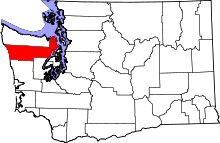
Discovery Bay is located on the Olympic Peninsula of Washington State. The bay enters the Strait of Juan de Fuca between the Miller and Quimper Peninsulas. The bay's mouth is just south of Protection Island, a small federally protected nature preserve. Discovery Bay is 6–7 miles in length, and a bit over a mile wide at its mouth. It is fed by Snow Creek, among other small watercourses.
Communities
The community of Discovery Bay, Washington is an area near the intersection of U.S. Route 101 and State Route 20, at the foot of Discovery Bay – roughly midway between the larger communities of Port Townsend and Sequim. It is a mix of residential areas and commercial enterprises, including crabbing, oystering, clamming, timbering, security training and gravel extraction. A few restaurants and stores on US 101 near SR 20 primarily serve drivers and truckers along US 101.

Discovery Bay is the current name generally associated with the area. Its use for the community, as opposed to the bay itself, is relatively recent. The original communities in the area, primarily mill towns that waxed and waned along with the local timber industry, had different names:
- Fairmont is a group of residences at the southeast corner of the bay, off SR20 just northeast of US101.
- Discovery Junction is an abandoned railroad junction near Fairmont.
- Uncas is an old mill community to the southwest of Fairmont, on the south side of US101.
- Fort Discovery is the original location of Capt. Vancouvers camp and the current day HQ of Security Services NW.
- Maynard is an old mill community to the north of Uncas, along US 101 at the southwest corner of the bay. A famous abandoned sawmill, just to the east of US101, is a well-known remnant of this community. That mill has often been incorrectly identified as the 1858 Port Discovery Mill (see Port Discovery, below). It was, in fact, the Maynard mill.
These names often appear on maps[2] and persist in local road names. The mill communities no longer have the population or visibility they enjoyed when the mills were operating, making these hamlets primarily matters of local historical interest. However, changing demographics and rising property values are leading to redevelopment of this area, and breathing new life into older names.
South Discovery now constitutes the entirety of the area around Discovery Bay, especially the area between Port Discovery and Port Townsend. The South Discovery voting precinct includes areas away from Discovery Bay, as well.
Several nearby place names are also prominent in Discovery Bay history:
- Eaglemount is an area on the hills to the south of Discovery Bay, on the east of US101 above high bluffs over Discovery Bay. (Eaglemount is sometimes depicted as a location on SR20, but in fact it is reached by turning south on Eaglemount Road from SR20.)
- Port Discovery is the location of George Vancouver's 1792 visit to Discovery Bay. Many sources incorrectly identify the current Discovery Bay community as the location of Port Discovery; however, Port Discovery was several miles away, at Mill Point. This is several miles further west along US101, near what today is called Broders Road.[3] Also see below for historical notes.
There are several other communities located on Discovery Bay. Proceeding clockwise from the northeast corner:
- Port Townsend occupies the northern end of the Quimper Peninsula, above the northeast corner of the bay. The downtown area of Port Townsend, a famous seaport (once the major port of the region, before the rise of Seattle), is on the opposite side of the peninsula.
- Cape George is located on high bluffs at the northeast entrance of the bay.
- Beckett Point is a shoreline community a mile south of Cape George.
- Adelma Beach is a shoreline community halfway down the bay.
- Gardiner is an unincorporated community several miles further west along US101, established by Herbert Gardner in the late 19th century. (The town name spelling originally matched that of its founder, but was later changed due to a conflict with another Gardner, Washington.)
- Diamond Point is located at the northwest mouth of the bay, opposite Protection Island. It once hosted a government quarantine station.
History
Native people – the Klallam (locally: S'Klallam) people – have occupied the lands around the Strait of Juan de Fuca for millennia, including locations on Discovery Bay. Most native populations on the Olympic Peninsula were relocated to reservations during the 19th and early 20th centuries, leaving only scattered individuals of native descent still residing on the bay.
The Spanish explorers Manuel Quimper (hence: Quimper Peninsula) and Gonzalo López de Haro in the Princesa Real are the first known Europeans to find and map the bay of Port Discovery. They were sent to explore the Strait of Juan de Fuca by Francisco de Eliza in 1790. The Spanish named the bay Puerto Quadra, after Juan Francisco de la Bodega y Quadra.[4]
In 1792, George Vancouver's exploration of the area provided names for Discovery Bay and Port Discovery. A landing party put ashore along the west shore of the bay near what is now Contractor's Point to fill water barrels from the creek there. Today, a sign alongside of Highway 101 above the site of the landing commemorates the event.
In 1858, the S. L. Mastick Company of San Francisco established the Port Discovery Mill on the western shore of the bay, at what today is called "Mill Point." The old growth timber on the steep hillsides above the mill were felled, slid down to the sawmill, milled into lumber and loaded from the wharf to ships for other ports. A village grew around the mill to house its employees. The peak population of the community, in the late 19th century, was in the hundreds. Port Discovery, Washington remained an important coastal port well into the 20th century, and was visited by many Pacific Ocean vessels.
The U.S. Federal Census of 1860 designated Port Discovery as one of three enumeration districts in Jefferson County. The indigenous people were not counted for this census. The total population was 70 and all but one were males between the ages of 20 and 52 years old. The one female was married to a cook and the only non-white person counted was an African-American male cook. Two thirds of the population were American-born, all of which had migrated west from other states. Of the third that were foreign born, all but one were from England, Ireland, Wales, or Canada. The exception was born in Sweden.
Another major mill community was established at the foot of the bay, where the town of Maynard grew. The Maynard mill continued in operation until the 1970s, and was responsible for the several nearby small communities mentioned above. The abandoned sawmill was a popular sight for tourists, and appears in many nostalgic area photographs and paintings. It deteriorated rapidly during storms in 2005–2006, and as of 2007 had been slated for removal, as part of a habitat restoration effort.
References
- ↑ "Discovery Bay". Geographic Names Information System. United States Geological Survey.
- ↑ e.g. maps.google.com – map of Port Discovery area
- ↑ Jefferson County Historical Society archives and publications, Port Townsend Washington
- ↑ Hayes, Derek (1999). Historical Atlas of the Pacific Northwest: Maps of exploration and Discovery. Sasquatch Books. p. 70. ISBN 1-57061-215-3.
- Jefferson County Historical Society, With Pride in Heritage: History of Jefferson County, Portland, Oregon, Professional Publishing Printing, Inc., 1966.
- United States Federal Census of Washington Territory 1860, ProQuest Image Databases, HeritageQuest Online, Series M653, Roll 1398, pp 46–47.
External links
- Survey of Historic Sites and Buildings - Discovery Bay, Washington, National Park Service
- U.S. Geological Survey Geographic Names Information System: Discovery Bay (populated place)
- U.S. Geological Survey Geographic Names Information System: Discovery Bay (bay)
Municipalities and communities of Jefferson County, Washington, United States | ||
|---|---|---|
| City | | |
| CDPs | ||
| Other unincorporated communities | ||
| Indian reservation | ||
| Ghost town | ||
| Footnotes | ‡This populated place also has portions in an adjacent county or counties | |
Coordinates: 47°59′24″N 122°53′31″W / 47.99000°N 122.89194°W