Dinkelscherben
| Dinkelscherben | ||
|---|---|---|
| ||
 Dinkelscherben | ||
Location of Dinkelscherben within Augsburg district 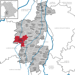 | ||
| Coordinates: 48°21′N 10°35′E / 48.350°N 10.583°ECoordinates: 48°21′N 10°35′E / 48.350°N 10.583°E | ||
| Country | Germany | |
| State | Bavaria | |
| Admin. region | Schwaben | |
| District | Augsburg | |
| Government | ||
| • Mayor | Edgar Kalb (Unabhängige Wählergruppe (UG)) | |
| Area | ||
| • Total | 67.70 km2 (26.14 sq mi) | |
| Population (2015-12-31)[1] | ||
| • Total | 6,517 | |
| • Density | 96/km2 (250/sq mi) | |
| Time zone | CET/CEST (UTC+1/+2) | |
| Postal codes | 86424 | |
| Dialling codes | 08292 | |
| Vehicle registration | A | |
| Website | www.dinkelscherben.de | |

Dinkelscherben is a municipality in the district of Augsburg in Bavaria in Germany. Fleinhausen, Anried, Breitenbronn, Ettelried, Grünenbaindt, Häder, Lindach, Oberschöneberg and Ried are villages that make up the municipality of Dinkelscherben.
References
- ↑ "Fortschreibung des Bevölkerungsstandes". Bayerisches Landesamt für Statistik und Datenverarbeitung (in German). June 2016.
This article is issued from Wikipedia - version of the 9/16/2016. The text is available under the Creative Commons Attribution/Share Alike but additional terms may apply for the media files.