Dingley Village, Victoria
| Dingley Village Melbourne, Victoria | |||||||||||||
|---|---|---|---|---|---|---|---|---|---|---|---|---|---|
 Dingley Village | |||||||||||||
| Coordinates | 37°58′52″S 145°07′41″E / 37.981°S 145.128°ECoordinates: 37°58′52″S 145°07′41″E / 37.981°S 145.128°E | ||||||||||||
| Population | 10,186 (2011 census)[1] | ||||||||||||
| • Density | 1,289/km2 (3,339/sq mi) | ||||||||||||
| Established | 1920s | ||||||||||||
| Postcode(s) | 3172 | ||||||||||||
| Area | 7.9 km2 (3.1 sq mi) | ||||||||||||
| Location | 22 km (14 mi) from Melbourne | ||||||||||||
| LGA(s) | City of Kingston | ||||||||||||
| State electorate(s) | |||||||||||||
| Federal Division(s) | Hotham | ||||||||||||
| |||||||||||||
Dingley Village is a suburb in Melbourne, Victoria, Australia, 22 km south-east from Melbourne's central business district. Its local government area is the City of Kingston. At the 2011 Census, Dingley Village had a population of 10,186.
History
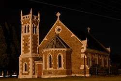
In 1856, Thomas Attenborough bought land in the area and named his house Dingley Grange, after Dingley Hall which exists in Dingley in his native Northamptonshire, England. A farming community developed, relatively remote from either the bayside or Gippsland railway lines, moving into market gardens and poultry to supply metropolitan markets. There was no identifiable centre to the area apart from Christ Church (1873) at the corner of Centre and Old Dandenong Roads, with its attractive architecture and bell tower. The Post Office opened on 21 July 1913.[2]
A family of five brothers – the Gartside – solved the problem of vegetable gluts by opening a cannery in about 1920. The cannery employed up to fifty local people. They donated land for the primary school which opened in 1925. In 1936 the Kingswood Golf Club, Dandenong, opened its new course at Dingley. A progress association was formed in 1947, and a recreation reserve acquired in 1954.
Urbanisation in Dingley began in the early 1960s. A small shopping centre, school, kindergarten, reserve and, later, Sunday Markets on the reserve created a village atmosphere which resulted in the official change of name.
Two more primary schools, one Catholic, opened later, along with the Spring Park Public Golf course and nearby tennis-courts complex. Near the Moorabbin Airport is an industrial zone set in a garden landscape, separated from the Dingley Village residential area by a reservation for the Mornington Peninsula Freeway.
The rock band Jet originated from the suburb.[3]
Education
Primary schools
- Dingley Primary School, established in 1925 and located on the corner of Centre Dandenong and Marcus roads.
- Kingswood Primary School established in 1976.
- St Mark's Primary School is a Catholic primary school within the Archdiocese of Melbourne.
Community facilities
Sporting facilities and clubs
- Dingley Baseball & Softball Club
- Dingley (Dingoes) Football Club competing in the Southern Football League.[4]
- Dingley Goodlife
- Dingley Netball Club
- Dingley Tennis Club
- Dingley Cricket Club
- Equest Park Equestrian Centre
- Peninsula-Kingswood Golf Club
- Southern Golf Club
- Souter and Corrigan Oval
- Spring Park Public Golf Course and Dingley Village Adventure Golf
Churches
- Heatherton-Dingley Uniting Church ("The Little White Church on the Corner")
- Christ Church Dingley
- Destiny Church Melbourne
- The Salvation Army – Kingston Gardens
- Village Church
- St. Mark's Catholic Church
See also
- City of Springvale – the former local government area of which Dingley Village was a part.
References
- ↑ Australian Bureau of Statistics (31 October 2012). "Dingley Village (State Suburb)". 2011 Census QuickStats. Retrieved 2012-06-21.
- ↑ Premier Postal History, Post Office List, retrieved 2008-04-11
- ↑ Holmes, Peter (24 September 2006), "Listen to Jet's new album", Sydney Confidential, retrieved 2006-04-29
- ↑ Full Point Footy, Southern Football League, retrieved 2008-10-21