Dervenochoria
| Dervenochoria Δερβενοχώρια | |
|---|---|
 Dervenochoria | |
|
Location within the regional unit 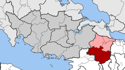 | |
| Coordinates: 38°13′N 23°30′E / 38.217°N 23.500°ECoordinates: 38°13′N 23°30′E / 38.217°N 23.500°E | |
| Country | Greece |
| Administrative region | Central Greece |
| Regional unit | Boeotia |
| Municipality | Tanagra |
| • Municipal unit | 222.94 km2 (86.08 sq mi) |
| Elevation | 566 m (1,857 ft) |
| Population (2011)[1] | |
| • Municipal unit | 1,869 |
| • Municipal unit density | 8.4/km2 (22/sq mi) |
| Time zone | EET (UTC+2) |
| • Summer (DST) | EEST (UTC+3) |
| Postal code | 190 12, 320 05 |
| Area code(s) | 26940 |
| Vehicle registration | ΒΙ |
Dervenochoria (Greek: Δερβενοχώρια) is a former municipality in Boeotia, Greece. Since the 2011 local government reform it is part of the municipality Tanagra, of which it is a municipal unit.[2] In 2011 its population was 1,869. The municipal unit has an area of 222.938 km2.[3] It covers the southernmost portion of Boeotia. The main village is Pyli.
Subdivisions
The municipal unit Dervenochoria is subdivided into the following communities (constituent villages in brackets):
History
The municipality was created in 1997.
Most of Dervenochoria was hit by a devastating wildfire (see 2007 Greek forest fires) on Thursday June 28, 2007 that came from Parnitha westward. Some damages to property including houses and buildings were reported. The aftermath was that much of the forest turned into an ashy landscape that may take years to restore its natural beauty.
References
- ↑ "Απογραφή Πληθυσμού - Κατοικιών 2011. ΜΟΝΙΜΟΣ Πληθυσμός" (in Greek). Hellenic Statistical Authority.
- ↑ Kallikratis law Greece Ministry of Interior (Greek)
- ↑ "Population & housing census 2001 (incl. area and average elevation)" (PDF) (in Greek). National Statistical Service of Greece.