Densole
| Densole | |
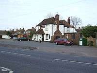 The Black Horse public house, Densole |
|
 Densole |
|
| OS grid reference | TR2147 |
|---|---|
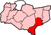
| District | Shepway |
| Shire county | Kent |
| Region | South East |
| Country | England |
| Sovereign state | United Kingdom |
| Post town | FOLKESTONE |
| Postcode district | CT18 |
| Dialling code | 01303 |
| Police | Kent |
| Fire | Kent |
| Ambulance | South East Coast |
| EU Parliament | South East England |
Coordinates: 51°07′56″N 1°09′35″E / 51.1322°N 1.1598°E
Densole is a small settlement in Kent located immediately north of Hawkinge on the A260 road between Folkestone and Barham. There is a public house: the Black Horse; a butterfly centre;[1] and camp sites at Densole. Also nearby is Reinden Woods, which is part of the East Kent Dry Training Area.The East Kent Dry Training Area is rural in character and is used extensively by the military for tactical training exercises. Situated within the Kent Downs Area of Outstanding Natural Beauty, Reinden Wood is an important habitat for woodland plants and butterflies. Walk description This walk was developed in conjunction with White Cliffs Countryside Project. Follow the Reinden Wood finger posts along the route. From the car park A (GR 213 409), follow the bridleway northwards to the edge of the wood B (GR 214 413). On meeting a gravelly/ semi metalled track, turn left and continue to follow the edge of the woodland. After about 1 km, C (GR 219 421) follow the path, right back into the wood, down a narrow track. At D (GR 222 420) take the left fork and follow the path southwestwards. When you reach the edge of the wood, follow the waymarkers, directing you back to the carpark A (GR 213 409).
Notes
External links
![]() Media related to Densole at Wikimedia Commons
Media related to Densole at Wikimedia Commons