Dender
| Dender/Dendre | |
|---|---|
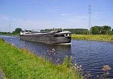 A ship on the Dender between Dendermonde and Aalst | |
| Country | Belgium |
| Basin | |
| Main source | Hainaut |
| River mouth |
Scheldt 51°02′42″N 4°05′20″E / 51.0449°N 4.0890°ECoordinates: 51°02′42″N 4°05′20″E / 51.0449°N 4.0890°E |
| Progression | Scheldt→ North Sea |
| Physical characteristics | |
| Length | 65 kilometres (40 mi) |
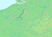
The Dendre (French) or Dender (Dutch) is a 65-kilometre (40 mi) long river in Belgium, right tributary of the river Scheldt. The confluence of both rivers is in the Belgian town of Dendermonde.
The Western or Little Dender springs near Leuze-en-Hainaut at an elevation of about 60 to 70 metres (200 to 230 ft) above sea level. The source of the Eastern Dender is near Jurbise at a height of 100 metres (330 ft) above sea level. The two rivers meet in the town of Ath. The length of the Western Dender up to Ath is 22 kilometres (14 mi); the Eastern Dender is 39 kilometres (24 mi) long. From that confluence the river is called the Dender proper. From Ath, the river passes in the Denderstreek through the cities and towns of Geraardsbergen, south of which its tributuary the Mark flows into it, Ninove and Aalst to end in Dendermonde. The Dender is navigable to Aalst for small ships up to 600 tons and further upstream for ships up to 350 tons. The Molenbeek-Ter Erpenbeek flows into the Dender at Hofstade.