Dempster Highway
| |||||||
|---|---|---|---|---|---|---|---|
|
Yukon Highway 5 Northwest Territories Highway 8 | |||||||
| Route information | |||||||
| Maintained by Yukon DOH&PW | |||||||
| Length: |
737.5 km (458.3 mi) YT-5: 465 km (289 mi) NWT-8: 272.5 km (169.3 mi) | ||||||
| Major junctions | |||||||
| South end: |
| ||||||
| North end: | Inuvik, NT | ||||||
| Highway system | |||||||
|
Territorial highways in Yukon
| |||||||


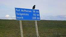
The Dempster Highway, also referred to as Yukon Highway 5 and Northwest Territories Highway 8, is a highway in Canada that connects the Klondike Highway in Yukon to Inuvik, Northwest Territories on the Mackenzie River delta. During the winter months, the highway extends another 194 km (121 mi) to Tuktoyaktuk, on the northern coast of Canada, using frozen portions of the Mackenzie River delta as an ice road (the Tuktoyaktuk Winter Road). The highway crosses the Peel River and the Mackenzie Rivers using a combination of seasonal ferry service and ice bridges.
The highway begins about 40 km (25 mi) east of Dawson City, Yukon on the Klondike Highway and extends 736 km (457 mi) to Inuvik, NT. Construction of the 140 km (87 mi) all-weather extension to Tuktoyaktuk commenced in April 2013, with completion scheduled for 2016.[1] Due to a combination of a short winter in 2015 and extremely cold weather in 2016, the completion date was extended to the 2017-2018 winter.[2]
History

Until 1978, the route was known simply as Highway 11. Much of the highway follows an old dog sled trail and the highway gets its name from Royal Canadian Mounted Police Inspector William John Duncan Dempster, who, as a young constable, frequently ran this dog sled trail from Dawson City to Fort McPherson NT. Inspector Dempster and two other constables were sent out on a rescue patrol in March 1911, to find Inspector Francis Joseph Fitzgerald and his team of three men, who never made it to Dawson City. They had become lost on the trail, and subsequently died of exposure and starvation. Dempster and his men found the bodies on March 22, 1911.[3]
In 1958, the Canadian government made the historic decision to build a 671 km (417 mi) road through the Arctic wilderness from Dawson City to Inuvik. Oil and gas exploration was booming in the Mackenzie Delta and the town of Inuvik was under construction. The road was billed as the first-ever overland supply link to southern Canada, where business and political circles buzzed with talk of an oil pipeline that would run parallel to the road. The two would ultimately connect with another proposed pipeline along the Alaska Highway.
On 17 August 1959, Ottawa announced that oil had been discovered in the territory’s Eagle Plains and, almost immediately, the government gave major concessions to the oil industry in an attempt to stimulate more exploration in the area. It was realised that a highway across the Arctic Circle would be needed to transport equipment, infrastructure and revenue to and from the sites. Consequently, construction began at Dawson City in January 1959. However, the highway's high costs, in addition to ongoing wrangling between the federal and Yukon governments kept progress at a snail’s pace until 1961, when building stopped altogether. Only 115 km (71 mi) of roadbed had been built before the project was abandoned.
There were no more developments until 1968, when a discovery of huge reserves of oil and gas at Prudhoe Bay, Alaska was made. This led to increased competition between the authorities in the United States and Canada. Billions of dollars were at stake, and political fortunes hung in the balance on both sides of the border. The Canadian government was afraid that the United States would develop the vast oil field with no consultation, no consideration and no benefits to its next-door neighbour. It wanted to assert Canadian sovereignty over the Arctic seabed off the Yukon's north coast in the Beaufort Sea, and over the waters among the Arctic islands which, though claimed by Canada, were asserted by the United States as high seas.
Construction
The Dempster Highway—Canada’s only all-weather road to cross the Arctic Circle—was officially opened on 18 August 1979, at Flat Creek, Yukon. It was unveiled as a two-lane, gravel-surfaced, all-weather highway that ran 671 km (417 mi) from the Klondike Highway near Dawson City to Fort McPherson and Arctic Red River (now Tsiigehtchic) in the Northwest Territories. In 1971, after three years of hard work, the Ogilvy River Bridge was completed by 3 Field Squadron, RCE from CFB Chilliwack, British Columbia. Later in 1977, the same unit completed the more challenging Eagle River Bridge. Ferries handle the traffic at the Peel River crossing near Fort McPherson and the Arctic Red River crossing near Tsiigehtchic.
The design of the highway is unique, primarily due to the intense physical conditions it is put through. The highway itself sits on top of a gravel berm to insulate the permafrost in the soil underneath. The thickness of the gravel pad ranges from 1.2 m (3 ft 11 in) up to 2.4 m (7 ft 10 in) in some places. Without the pad, the permafrost would thaw and the road would sink into the ground.
In addition to services in Fort McPherson, Tsiigehtchic and Inuvik, there is one location with commercial services along the highway, at Eagle Plains. It is an important fuel and food stop because of the great distance, and harbours stranded travelers when the highway is closed due to extreme weather conditions. (Until 1979, the highway was only open in the short summer.)
During the early 1990s, Northwestel erected microwave towers along the highway to facilitate public safety with manual mobile telephone service and to provide government agencies such as highway maintenance and the Royal Canadian Mounted Police with communications. The microwave project was opposed by some environmental interests and those who preferred the pristine appearance of the route. A suggestion to install fiber optics would not have enabled mobile communications. Since then, the route has become the terrestrial link to the exchanges in the Mackenzie Delta region.
Upon campaigning during the spring 2011 election, the Prime Minister of Canada Stephen Harper announced that it was his intention to complete the highway with a 140 km (87 mi) extension to Tuktoyaktuk. The 2012 federal budget announced $150 million for the project, and this commitment was increased March 2013 to $200 million. The Inuvialuit completed an environmental review of the project in January 2013 and provided their approval, and in March 2013 NWT legislature approved $65 million, and construction of the all-weather highway commenced in April 2013.[4][5]
Gallery
 Arctic spruce
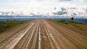 Dempster Highway
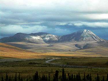
 Tombstone Mountains from Highway
 Sign in Eagle Plains: "High winds and blowing snow"
 Midnight sun over the Dempster near Inuvik
See also
References
- ↑ "Preparations for Tuktoyaktuk highway construction underway". CBC News. Canadian Broadcasting Corporation. 10 April 2013. Retrieved 7 July 2015.
- ↑ "Inuvik-to-Tuk highway will complete Canada’s road network coast to coast", TheSTAR Canada, http://www.thestar.com/news/canada/2016/02/14/inuvik-to-tuk-highway-will-complete-canadas-road-network-coast-to-coast.html
- ↑ North, Dick (2004). The Lost Patrol: The Mounties' Yukon Tragedy. Globe Pequot. ISBN 1-59228-573-2.
- ↑ "Inuvik to Tuktoyaktuk Highway". Canada's Economic Action Plan. Infrastructure Canada. Retrieved 7 July 2015.
- ↑ "Tuktoyaktuk highway gets cash boost". CBC News. Canadian Broadcasting Corporation. 12 March 2013. Retrieved 7 July 2015.
External links
| Wikimedia Commons has media related to Dempster Highway. |
| Wikivoyage has a travel guide for Dempster Highway. |
- Opening of the Dempster Highway
- Map of the highway
- Dempster Highway at Inuvik Town website
- Dempster Highway at Travel Yukon
- Dempster Highway road trip article on the Economist's More Intelligent Life website
- Detailed Dempster Highway article by Dallas Morning News travel writer Dave Levinthal
| Highways | ||
|---|---|---|
| Other roads | ||