Delaware Route 62
| ||||
|---|---|---|---|---|
 | ||||
| Route information | ||||
| Maintained by DelDOT | ||||
| Length: | 2.65 mi[1] (4.26 km) | |||
| Existed: | 1981[2] – present | |||
| Major junctions | ||||
| West end: | Old Capitol Trail in Prices Corner | |||
|
| ||||
| East end: | Dead end near Newport | |||
| Location | ||||
| Counties: | New Castle | |||
| Highway system | ||||
| ||||

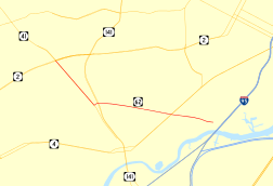
Delaware Route 62 (DE 62) is a state highway in New Castle County, Delaware in the United States. The route officially runs from Old Capitol Trail in Prices Corner east to a dead end near Newport; however, DE 62 is signed from an intersection with DE 2 and the southern terminus of DE 41 in Prices Corner to the DE 4 intersection. The road runs through suburban areas along Newport Gap Pike and Boxwood Road, interchanging with DE 141. The Newport Gap Pike portion of road was built as a state highway by 1925 and became part of DE 41 by 1936. Boxwood Road was improved in 1946. DE 62 was assigned to its current alignment by 1981.
Route description

DE 62 heads southeast from Old Capitol Trail on the Newport Gap Pike, a two-lane undivided road. Newport Gap Pike continues northwest past this intersection to DE 2 (Kirkwood Highway), where the road becomes DE 41. Signage has DE 62 follow Newport Gap Pike northwest to the DE 2/DE 41 intersection. DE 62 heads through suburban residential and commercial developments, crossing the Wilmington and Western Railroad and CSX's Philadelphia Subdivision. The road passes more development and reaches the community of Belvedere, where it comes to a ramp from southbound DE 141.[3][4]
At this point, the route turns east onto Boxwood Road, a four-lane divided highway, with Newport Gap Pike continuing south to provide access to southbound DE 141. DE 62 passes over the DE 141 freeway and intersects Centerville Road, which provides access to and from northbound DE 141. Past this intersection, the road becomes two lanes and undivided, passing to the south of the former Wilmington Assembly plant used by General Motors and to the north of residential subdivisions. DE 62 continues through more residential neighborhoods, passing to the north of the Conrad Schools of Science, and reaches an intersection with DE 4, where DE 62 signage ends. The route officially continues east on Middleboro Road through more neighborhoods, intersecting Dupont Road before coming to a dead end.[3][4] DE 62 has an annual average daily traffic count ranging from a high of 13,544 vehicles at the DE 141 interchange to a low of 262 vehicles at the eastern terminus.[1] None of DE 62 is part of the National Highway System.[5]
History
What is now the Newport Gap Pike portion of DE 62 was originally chartered as the Gap and Newport Turnpike in 1808, an extension of the 1807-chartered turnpike in Pennsylvania that was to run from Gap, Pennsylvania, southeast to Newport, Delaware.[6] By 1920, what is now DE 62 existed as a county road.[7] The Newport Gap Pike portion of the route became a state highway by 1925.[8] This state highway became a part of DE 41 by 1936, when Delaware designated its state highways.[9] In 1946, Boxwood Road was improved to provide access to the new General Motors plant along the road.[10] By 1981, DE 62 was designated onto its current alignment, with the Newport Gap Pike section replacing a portion of DE 41.[2]
Major intersections
The entire route is in New Castle County.
| Location | mi[1] | km | Destinations | Notes | |
|---|---|---|---|---|---|
| Prices Corner | 0.00 | 0.00 | Old Capitol Trail / Newport Gap Pike | Western terminus, signage continues to DE 2/DE 41 intersection | |
| Belvedere | 0.73 | 1.17 | DE 141 exit 5 | ||
| Newport | 1.92 | 3.09 | Eastern terminus of DE 62 signage | ||
| 2.65 | 4.26 | Dead end | Eastern terminus | ||
| 1.000 mi = 1.609 km; 1.000 km = 0.621 mi | |||||
See also
 U.S. Roads portal
 Delaware portal
References
- 1 2 3 Staff (2011). "Traffic Count and Mileage Report: Interstate, Delaware, and US Routes" (PDF). Delaware Department of Transportation. Retrieved May 17, 2012.
- 1 2 Delaware Department of Transportation (1981). Delaware Official State Highway Map (PDF) (Map). Dover: Delaware Department of Transportation. Retrieved November 24, 2015.
- 1 2 Delaware Department of Transportation (2008). Delaware Official Transportation Map (PDF) (Map). Dover: Delaware Department of Transportation. Retrieved November 24, 2015.
- 1 2 Google (September 4, 2010). "Overview of Delaware Route 62" (Map). Google Maps. Google. Retrieved September 4, 2010.
- ↑ National Highway System: Delaware (PDF) (Map). Federal Highway Administration. 2010. Retrieved February 10, 2012.
- ↑ Scharf, John Thomas (1888). History of Delaware: 1609–1888, Volume 1. Philadelphia: L.J. Richards. p. 416. OCLC 2471701. Retrieved February 7, 2011.
- ↑ Delaware State Highway Department (1920). Official Road Map (PDF) (Map). Dover: Delaware State Highway Department. Retrieved November 24, 2015.
- ↑ Delaware State Highway Department (1925). Official Road Map (PDF) (Map). Dover: Delaware State Highway Department. Retrieved November 24, 2015.
- ↑ Delaware State Highway Department; The National Survey Co. (1936). Official Road Map of the State of Delaware (PDF) (Map) (1936–37 ed.). Dover: Delaware State Highway Department. Retrieved November 24, 2015.
- ↑ "Report of the State Highway Department" (PDF) (1946 ed.). Dover, Delaware: Delaware State Highway Department. July 1, 1946: 24–25. Retrieved November 17, 2014.
External links
 Media related to Delaware Route 62 at Wikimedia Commons