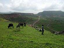
Degua Tembien
Degua Tembien (Tigrinya "Upper Tembien") is one of the woredas in the Tigray Region of Ethiopia. It is named in part after the former province of Tembien. Part of the Mehakelegnaw Zone, Degua Tembien is bordered on the south by the Debub Misraqawi (South Eastern) Zone, on the west by Abergele, on the north by Kola Tembien, and on the east by the Misraqawi (Eastern) Zone. The administrative center of this woreda is Hagere Selam.
Notable landmarks in this woreda include the Hadmet Caves, a limestone cave system opening into the Kworiora River gorge near Adi Idaga. The entrance is behind a waterfalls 100 meters in height.[1]
Demographics
Based on the 2007 national census conducted by the Central Statistical Agency of Ethiopia (CSA), this woreda has a total population of 113,595, an increase of 27.58% over the 1994 census, of whom 56,955 are men and 56,640 women; 7,270 or 6.40% are urban inhabitants. With an area of 1,852.89 square kilometers, Degua Tembien has a population density of 61.31, which is greater than the Zone average of 56.29 persons per square kilometer. A total of 25,290 households were counted in this woreda, resulting in an average of 4.49 persons to a household, and 24,591 housing units. The majority of the inhabitants said they practiced Ethiopian Orthodox Christianity, with 99.89% reporting that as their religion.[2]
The 1994 national census reported a total population for this woreda of 89,037, of whom 44,408 were men and 44,629 were women; 3,932 or 4.42% of its population were urban dwellers. The largest ethnic group reported in Degua Tembien was the Tigrayan (99.87%). Tigrinya was spoken as a first language by 99.89%. 99.79% of the population practiced Ethiopian Orthodox Christianity. Concerning education, 7.17% of the population were considered literate, which is less than the Zone average of 14.21%; 7.73% of children aged 7-12 were in primary school; 0.14% of the children aged 13-14 were in junior secondary school, and 0.21% of the inhabitants aged 15-18 were in senior secondary school. Concerning sanitary conditions, about 29% of the urban houses and 15% of all houses had access to safe drinking water at the time of the census; 6% of the urban and 2.4% of the total had toilet facilities.[3]
Agriculture
A sample enumeration performed by the CSA in 2001 interviewed 22,002 farmers in this woreda, who held an average of 0.79 hectares of land. Of the 17,387 hectares of private land surveyed, 91.06% was in cultivation, 0.55% pasture, 4.8% fallow, 0.13% woodland, and 2.99% was devoted to other uses. For the land under cultivation in this woreda, 77.88% was planted in cereals, 11.7% in pulses, and 1.36% in oilseeds; the area planted in vegetables is missing. Ten hectares were planted in fruit trees and eleven in gesho. 71.93% of the farmers both raised crops and livestock, while 28.07% only grew crops; the number who only raised livestock is missing. Land tenure in this woreda is distributed amongst 82.12% owning their land, 17.43% renting and 0.44 holding their land under other forms of tenure is missing.[4]
Surrounding woredas

References
- ↑ "Stalagmite sampling results table", Ethiopian Venture, First phase: Climate Reconstruction (accessed 17 May 2009)
- ↑ Census 2007 Tables: Tigray Region, Tables 2.1, 2.4, 2.5 and 3.4.
- ↑ 1994 Population and Housing Census of Ethiopia: Results for Southern Nations, Nationalities and Peoples' Region, Vol. 1, part 1 Archived November 19, 2008, at the Wayback Machine., Tables 2.1, 2.12, 2.19, 3.5, 3.7, 6.3, 6.11, 6.13 (accessed 30 December 2008)
- ↑ "Central Statistical Authority of Ethiopia. Agricultural Sample Survey (AgSE2001). Report on Area and Production - Tigray Region. Version 1.1 - December 2007" Archived November 14, 2009, at the Wayback Machine. (accessed 26 January 2009)
Coordinates: 13°30′N 39°15′E / 13.500°N 39.250°E
Woredas of the Mehakelegnaw Zone | ||
|---|---|---|
 | ||