Dausa district
| Dausa district Dausa District | |
|---|---|
| District of Rajasthan | |
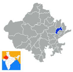 Location of Dausa district in Rajasthan | |
| Country | India |
| State | Rajasthan |
| Administrative division | Jaipur Division |
| Headquarters | Dausa |
| Area | |
| • Total | 3,432 km2 (1,325 sq mi) |
| Population (2011) | |
| • Total | 16,34,409[1] |
| Demographics | |
| • Literacy | 68.16 |
| • Sex ratio | 905 |
| Major highways | National Highway 11 (NH-11) |
| Coordinates | 26°32′N 76°11′E / 26.54°N 76.19°ECoordinates: 26°32′N 76°11′E / 26.54°N 76.19°E |
| Average annual precipitation | 459.8 mm |
| Website | Official website |
Dausa District is a district of Rajasthan state in western India. The city of Dausa is the district headquarters. It has a population of 16,34,409 (2011 census), an area of 3034 km², and a population density of 384 persons per km² with 62.75% literacy rate. It is bounded on the north by Alwar District, on the northeast by Bharatpur District, on the southeast by Karauli District, on the south by Sawai Madhopur District, and on the west by Jaipur District. The district is divided into Eight tehsils, Baswa, Dausa, Lalsot, Mahwa, Sikrai, Lawan, Nangal Rajawatan and Ramgarh Panchwara. The Sawa and Ban Ganga rivers run through the district. It is situated on National Highway no.11 From Jaipur to Agra. It is 55 km to the east of Jaipur. In Tehsil Mahwa there is a Gram Panchayat, Kherla Bujurg, it is famous for a record which was made during an election of member for legislative assembly Mahwa seat for Rajasthan Vidhan Sabha. All three candidates from National parties were resident this village, all of these three were from same cast (Gurjar), all were advocate by there profession. Eventually Hari Singh Gurjar was elected. BBC news services broadcast a special programme about it.
History
Dausa is named after a hill near the city that was called Devgiri. On the top of hill is situated a fort, built by Badgujar Kings, who were the orininal rulers of this area. Later, Dausa was given by Chauhans to Kachwahas, but the centre of their power shifted to Amber.
When Akbar went to Ajmer as a pilgrim to Khwaja Moinuddin Chisti in 1562, he stayed in Dausa and met with Rupsi Baragi, Hakim of Dausa at the time and brother of Bharmal. Agriculture is the main occupation of the people of Dausa. The main crops of the district are wheat, bajra, rapeseed, mustard and groundnuts.
Dausa District was constituted on 10 April 1991 by separating four tehsils, namely Dausa, Baswa, Sikrai, & Lalsot from Jaipur district. Mahwa Tehsil of Sawai Madhopur was included in this district on 15 August 1992.
Statistical data
Dausa is not the smallest district of Rajasthan by area. Dholpur is the smallest district, at 3,034 square km, while Dausa is 3,432 square km.
Demographics
According to the 2011 census Dausa district has a population of 1,637,226,[2] roughly equal to the nation of Guinea-Bissau[3] or the US state of Idaho.[4] This gives it a ranking of 305th in India (out of a total of 640).[2] The district has a population density of 476 inhabitants per square kilometre (1,230/sq mi) .[2] Its population growth rate over the decade 2001-2011 was 24.31%.[2] Dausa has a sex ratio of 904 females for every 1000 males,[2] and a literacy rate of 69.17%.[2]
References
- ↑ "Name Census 2011, Dausa Handbook data" (PDF). censusindia.gov.in. 2016. Retrieved 28 February 2016.
- 1 2 3 4 5 6 "District Census 2011". Census2011.co.in. 2011. Retrieved 2011-09-30.
- ↑ US Directorate of Intelligence. "Country Comparison:Population". Retrieved 2011-10-01.
Guinea-Bissau 1,596,677 July 2011 est.
- ↑ "2010 Resident Population Data". U. S. Census Bureau. Retrieved 2011-09-30.
Idaho 1,567,582
External links
 |
Alwar district | | ||
| Jaipur district | |
Bharatpur district | ||
| ||||
| | ||||
| Sawai Madhopur district | Karauli district |
| Outline |  | ||||||||||||||||||||||||||
|---|---|---|---|---|---|---|---|---|---|---|---|---|---|---|---|---|---|---|---|---|---|---|---|---|---|---|---|
| Governance | |||||||||||||||||||||||||||
| Divisions and Districts |
| ||||||||||||||||||||||||||
| Major cities | |||||||||||||||||||||||||||
| Related templates |
| ||||||||||||||||||||||||||