Kandıra
| Kandıra | |
|---|---|
 Kandıra | |
| Coordinates: 41°04′20″N 30°09′40″E / 41.07222°N 30.16111°ECoordinates: 41°04′20″N 30°09′40″E / 41.07222°N 30.16111°E | |
| Country |
|
| Province | Kocaeli |
| Government | |
| • Mayor | Cengiz Kan (AKP) |
| • Kaymakam | Kemal Yıldız |
| Area[1] | |
| • District | 921.05 km2 (355.62 sq mi) |
| Population (2012)[2] | |
| • Urban | 14,744 |
| • District | 50,042 |
| • District density | 54/km2 (140/sq mi) |
| Website |
www |
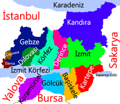
Kandıra is a town and district of Kocaeli Province in the Marmara region of Turkey. Its neighbours are Kaynarca to the east, Adapazarı to the southeast, İzmit to the south and Şile to the west.
Geography
Kandira has an area of 933 km2 (360,2 mi2). Of this area, almost 50% is used for agricultural purposes, while almost 40% is forested. Of the rest of the land, 4% is settled (buildings or roads and the remainder)
History
Kandira is first mentioned as Kéndri or Kándora.
Hospital
The state hospital of Kandira was founded in 1949.
Tourist attractions
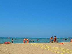
Tourists discovered Kerpe when it was a small fishing port. It boasts a calm sea and sandy beaches, and is close to urban centers such as Istanbul, İzmit, and Adapazarı.
Kefken is 20 km away from Kandıra, and 8 km away from Kerpe. Kefken is the most advanced town among the coastal settlements of the district. Sea, beach and pine forests are the most important features. Kefken harbor is a typical fishing town. In the summertime the town gets 3 times crowded. 2 hours more or less, or 150 km away from Istanbul on the Black Sea coast, is this fairly secluded, quiet, and relatively unspoilt part of the region. The sea is suitable for swimming and there are unspoilt bays for picnics. Kefken Island is one of the few islands on the Turkish Black Sea coast. The island is at a close distance to the shores of Cebeci village. Genoese era fortress walls and water wells are worth to mention as the historical heritage of the island.
Other places
- Cebeci
- Kumcağız
- Bağırgan
- Kovanağzı
- Sarısu
- Dikili
References
- ↑ "Area of regions (including lakes), km²". Regional Statistics Database. Turkish Statistical Institute. 2002. Retrieved 2013-03-05.
- ↑ "Population of province/district centers and towns/villages by districts - 2012". Address Based Population Registration System (ABPRS) Database. Turkish Statistical Institute. Retrieved 2013-02-27.
- "Tourism Potentials of Kandıra" (in Turkish). Governorship of Kandıra, Kocaeli. 2009. Retrieved 2009-08-19.
External links
- District governor's official website (Turkish)
- District municipality's official website (Turkish)
- Kandira Hotel Guide