Danubian Limes
The Danubian Limes (German: Donaulimes), or Danube Limes, refers to that part of the Roman military frontier or Limes which lies along the River Danube in the present-day German state of Bavaria, in Austria, Slovakia, Hungary, Serbia, Bulgaria and Romania.
Unlike the Neckar-Odenwald Limes in Germany the border ramparts were reinforced with numerous watchtowers, legion camps (castra) and forts (castella), due to the boggy and dendritic nature of the river banks. The camps were built in the mid-1st century. Later, under Trajan, the camps, which had originally only been surrounded by earthen embankments, were also enclosed by stone walls.
A Roman road, the Danube Way (Lat.: Via Istrum) was laid along the Limes, which linked the stations, camps and forts as far as the Danube delta.[1]
Subdivisions
Because of the sheer length of this border, the Danubian Limes is often divided into the following subdivisions:
- Rhaetian Limes, only those elements along the Danube being counted as part of the Danubian Limes.
- Noric Limes
- Pannonian Limes (in Upper and Lower Pannonia)
- Moesian Limes or also
- Dacian Limes (from the task of Roman Dacia north of the Danube by Aurelian)
-
The Upper Germanic-Rhaetian Limes between the Rhine and the Danube
-
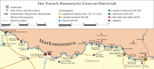
The Noric-Pannonian Limes in present-day Austria
-

The Pannonian Limes in present-day Hungary
-

The Moesian Limes in present-day Bulgaria and Romania
Germany and Austria
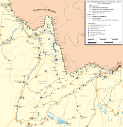
The oldest Roman camp in Austria was Carnuntum. Fourteen kilometres away to the west an auxiliary fort (Hilfskastelle) was built near Schlögen (today in the municipality of Haibach ob der Donau) in Upper Austria. At that time, the limes ran from Vienna to Linz roughly following the present-day Wiener Straße (B 1).
Because the Danube did not always provide the necessary protection, bridgeheads were built on its northern banks against the Marcomanni, such as the one in Stillfried or at the Oberleiser Berg. However, these were cleared again under Marcus Aurelius' son, Commodus, and a seven-kilometre-wide 'death strip' laid along the Danube.
The increasing number of fortifications that were falling into decay were renovated again under Emperor Valentinian I (364–375) and conformed to the latest battle tactics. Walls were thickened up and defensive ditches renewed. In addition, towers were built along the walls. For example, a watchtower was discovered near Oberranna in 1960. This fortification lasted only another hundred years, however. In 488 the land of present-day Austria was cleared. The Roman fortifications along the lower courses of the Danube were overhauled once again, especially under Anastasios I and Justinian I They finally served during Maurice's Balkan campaigns his successor, Phocas, as a basis for larger military operations and some were maintained in the province of Moesia Secunda until the invasion of the Bulgars in 679.
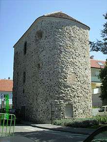
A few defensive towers survive: in Bacharnsdorf in Lower Austria, in Mautern (Favianis) and in Traismauer (Augustiana). In Tulln and Zeiselmauer, too, there are surviving remnants. In the Kürnberg Forest near Linz there are remains of a watchtower from the Roman period.
Legion camps were established in:[2]
Camps (castrae) and forts (castella) in Austria from west to east:[2]
- Stanacum (Engelhartszell)
- Ioviacum (Schlögen)
- Ad Mauros (Eferding)
- Lentia (Linz)
- Ad Iuvense (Wallsee)
- Arelape (Pöchlarn)
- Namare (Melk an der Donau)
- Favianis (Mautern)
- Barbaricum (Fels am Wagram – nördlich der Donau)
- Augustianis (Traismauer)
- Asturis (Zwentendorf)
- Comagena (Tulln)
- Cannabiaca (Zeiselmauer)
- Arrianis/Asturis (Klosterneuburg)
- Ala Nova (Schwechat)
- ? (Mikulov-Tschechien)
- Aequinoctium (Fischamend)
- Roman fort, Höflein (Höflein)
- Roman fort, Stopfenreuth (Engelhartstetten)
Lower Danube


On the Lower Danube, between the present-day Bulgaria and Romania, a Roman road, the Low Danubian Road, was built during the reign of the Emperor, Tiberius, in the 1st century AD on the right-hand, Bulgarian side of the river.
Roman camps, smaller garrisons and watchtowers were built on both sides of the Danube. Civilian settlements, predominantly for veterans and former legionaries were also built. The following Roman garrisons were the first to be established during the 1st century on the Lower Danube:
- Augustae (near the village of Hurlets)
- Valeriana (near the village of Dolni Vadin)
- Variana (near the village of Leskowez)
- Almus (near the town of Lom)
- Regianum (near the town of Kozloduy)
- Sexaginta Prista (near the town of Ruse)
- Dorostorum (near the town of Silistra)
- Ratiaria (near the town of Artschar)
- Novae (near the town of Svishtov)
- Viminatium
- Singidunum (Belgrad)
- Oescus
See also
References
- ↑ The widespread name for the lower courses of the Danube river in Roman times was the Ister.
- 1 2 The Roman Limes in Austria retrieved 25 May 2009
Literature
- Ralph F. Hoddinott: Bulgaria in Antiquity. An archeological introduction. Ernest Benn Ltd., London, 1975, ISBN 0-510-03281-8, pp. 111–142.
- Kurt Genser: Der Donaulimes in Österreich (= Schriften des Limesmuseums Aalen. Vol. 44). Württembergisches Landesmuseum, Stuttgart, 1990.
- Gerda von Bülow et al. (eds.): Der Limes an der unteren Donau von Diokletian bis Heraklios. Vorträge der Internationalen Konferenz Svištov, Bulgarien (1–5 September 1998). Verlag NOUS, Sofia, 1999, ISBN 954-90387-2-6.
- Susanne Biegert (ed.): Von Augustus bis Attila. Leben am ungarischen Donaulimes (= Schriften des Limesmuseums Aalen. Vol. 53). Theiss, Stuttgart, 2000, ISBN 3-8062-1541-3.
- Herwig Friesinger et al. (eds.): Der römische Limes in Österreich. Führer zu den archäologischen Denkmälern. 2nd, revised edition. Verlag der Österreichischen Akademie der Wissenschaften, Vienna, 2002, ISBN 3-7001-2618-2.
- Sonja Jilek: Grenzen des Römischen Reiches: Der Donaulimes, eine römische Flussgrenze. Uniwersytet Warszawski, Warsaw, 2009, ISBN 978-83-928330-7-9.
External links
- Monuments Board of the Slovak Republic (publ.): Danube Limes in Slovakia. Ancient Roman Monuments on the Middle Danube. Printed Final Document to nominate the Slovakian Limes as a UNESCO World Heritage Site. Bratislava, 2011, retrieved 4 May 2013 (pdf; 5.8 MB).
- Zsolt Máté u. a.: Frontiers of the Roman Empire. Ripa Pannonica in Hungary (RPH). Nomination statement Vol. 1. National Office of Cultural Heritage, Budapest, 2011, ISBN 978-963-7474-31-6, retrieved 4 May 2013 (pdf; 3.1 MB).
- Zsolt Máté u. a.: Frontiers of the Roman Empire. Ripa Pannonica in Hungary (RPH). Nomination statement Vol. 2. Maps and plans, showing the boundaries of the nominated property and the buffer zone. National Office of Cultural Heritage, Budapest, 2011, retrieved 4 May 2013 (pdf; 119 MB).
- Zsolt Visy: The Danube Limes Project Archaeological Research Between 2008–2011. University of Pécs, Department of Archaeology, Pécs, 2011, ISBN 978-963-642-447-3, retrieved 4 May 2013 (pdf; 24 MB).
- Beitrag im ORF
- Information pages on the Danubian Limes (German, English)