Daniel Boone National Forest
| Daniel Boone National Forest | |
|---|---|
|
IUCN category VI (protected area with sustainable use of natural resources) | |
|
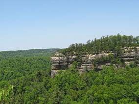
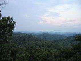
View from Tater Knob in the Daniel Boone National Forest | |
 | |
| Location | Kentucky, USA |
| Nearest city | Winchester, Kentucky |
| Coordinates | 37°17′17″N 83°52′31″W / 37.28806°N 83.87528°WCoordinates: 37°17′17″N 83°52′31″W / 37.28806°N 83.87528°W |
| Area | 2,100,000 acres (8,500 km2) (proclamation boundary); 706,000 acres (2,860 km2) (Forest Service) |
| Established | February 23, 1937[1] |
| Visitors | 2,507,000 (in 2004) |
| Governing body | U.S. Forest Service |
| Website | Daniel Boone National Forest |
Daniel Boone National Forest is the only national forest completely within the boundary of Kentucky. Established in 1937, it was originally named the Cumberland National Forest, after the core region called the Cumberland Purchase Unit. About 2,100,000 acres (8,500 km2) are contained within its current proclamation boundary, of which 706,000 acres (2,860 km2) are owned and managed by the United States Department of Agriculture Forest Service (as of April 2006), up from around 620,000 acres (2,500 km2) in the early to mid-1990s.
The forest was named after Daniel Boone, a frontiersman and explorer in the late 18th century who contributed greatly to the exploration and settlement of Kentucky.
History
In 1937, a national forest was established containing 1,338,214 acres (5,416 km2) within its proclamation boundary. As of June 1937, the Forest Service had purchased only 336,692 acres (1,363 km2). Most early purchases were large, isolated tracts owned by lumber and coal companies with but few inhabitants. The Forest Service has since had difficulty acquiring more land within the proclamation boundary, the bulk of which was, and still remains, small owner-operated farms.
Due in part to World War II, funds for land acquisition were curtailed in the early 1940s. Substantial acquisition efforts could not resume until the mid-1960s. The lengthy cessation of land acquisitions, except for period during the forest's renaming, caused a highly fragmented ownership pattern.
Naming the forest entailed considerable debate. The name 'Daniel Boone National Forest' was advocated by various groups, and was favored by most local leaders in Kentucky, before the area's formal designation as the Cumberland National Forest soon after its inception. Protests began immediately after the national forest was named.
The naming issue was reopened in the late 1950s. The Forest Service investigated the name 'Cumberland', and found it came to Kentucky in 1750 when Thomas Walker named the Cumberland River in honor of Prince William Augustus, Duke of Cumberland. The Duke had defeated the Scottish Highlanders in 1746 at the Battle of Culloden, an especially brutal conflict. Many Scottish families fled to America and ultimately Kentucky as a result of the event. The Forest Service found that for their descendants still living in Eastern Kentucky, the name 'Cumberland' was particularly distasteful.[2]
In addition, the Forest Service noted the influence of history on the names of places in Kentucky. While the settlement of the region began before the American Revolution, the population grew dramatically after the Revolutionary War, when many veterans received land grants in reward for military service. During this period of time, place names with British connotations fell out of favor and changes were made. For example, prior to the Revolution, the Kentucky River was called the Louisa River (or Levisa Fork), after the wife of the Duke of Cumberland.
During the 1960s, a new movement to rename the national forest took place. The Kentucky Senate passed a resolution in 1966 urging the Forest Service to change the name to 'Daniel Boone National Forest', and President Lyndon B. Johnson signed a proclamation so renaming the forest in 1966.
Also during the 1960s, part of the national forest was designated a Primitive Weapons Area (renamed Pioneer Weapons Area) and set apart for hunting with longbow, crossbow, or muzzle-loading firearms (either flintlock or percussion). In 1970, this was the only US area where deer could legally be hunted with crossbows. The park remains unique still for allowing only muzzle-loaded firearms.
In 1967, a large and disconnected addition to the national forest was created, called the Redbird Purchase Unit, after a key purchase from the Red Bird Timber Company. According to Robert F. Collins of the Forest Service, Thomas R. Frazier (born July 7, 1931; died February 1, 2008) was the first District Ranger of the Redbird Purchase Unit, and is credited as being a major factor in the success of the Redbird land purchasing unit ("A History of the Daniel Boone National Forest", dedication page, 1975).
Recent controversies

About a third of the land within the national forest proclamation boundary is owned or managed by the Forest Service. The pattern of land ownership is highly fragmented and changes relatively frequently. One of the goals of the Forest Service is to consolidate holdings into larger blocks, which is often done by trading tracts with other organizations. The boundaries of Forest Service lands are marked in various ways, including red paint on trees. The shifting boundaries and growing size of Forest Service lands sometimes results in local complaints and boundary disputes. In addition, it can be difficult for recreational users to know whether they are on Forest Service lands or not. "No Trespassing" signs are frequently used by landowners, and conflicts between landowners and recreational users are not uncommon.
As is common in many national forests, some recreational users trespass on private property, sometimes leaving litter, campfire rings, and causing other damage. In contrast, the population of eastern Kentucky have long been strong proponents of property rights. Feelings of local ownership traditionally extended into nearby public lands, used as woodlots, for hunting and herb gathering, and other such uses. The conflict between long-term local residents and recreational users is exacerbated by the highly fragmented pattern of land ownership.
On many commercially available maps, the whole region within the proclamation boundary is shown as solid green, but the national forest is actually a patchwork of tracts intermingled with private, county, and state properties. Tracts are often shuffled through swaps, barters and exchange, or purchase. One example is the nearly un-forested quarry tracts swapped near Clearfield's Clack Mountain for land on the Licking River in Rowan County.
Boundary disputes are often not contested in court when landowners find the commercial value of disputed land is less than the legal cost of fighting the Forest Service. Some of those affected claim the government takes advantage of archaic deed language and vague border markers or descriptions to shave away property in favor of forest holdings. Local county governments receive permanent fund payments in lieu of property taxes from the USDA, which not only provides revenue but can increase their bond rating, providing further financial incentives for the process to continue.
Issues such as logging and wildlife protection have resulted in lawsuits; a logging proposal was canceled in 2012 in the Rockcastle County region of the forest.[3] The successful introduction of red wolves to nearby Great Smoky Mountains National Park, as well as failed attempts at other nearby areas, such as the Land Between the Lakes, has generated concern and debate throughout the Appalachian region.
Notable features
Daniel Boone National Forest surrounds or contains a variety of popular and notable features, including:
- One of the world's largest concentrations of caves. The counties of Wayne, Pulaski, and Rockcastle alone have 173 miles (278 km) of mapped passageways [4][5] Many of these caves have been closed by the Forest Service to prevent and slow the spread of white-nose syndrome, a disease complex that is killing thousand of bats across the northeastern to Midwestern United States.
- Cave Run Lake - a USACE reservoir
- Laurel River Lake - a USACE reservoir
- Buckhorn Lake - a USACE reservoir
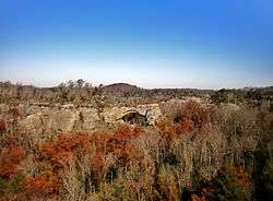
- Red River Gorge Geological Area - popular with hikers, campers, and rock climbers
- Sheltowee Trace National Recreation Trail
- Yahoo Arch
- Yahoo Falls
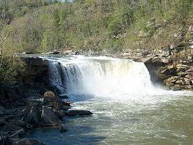
- Cumberland Falls
- Rock Creek Research Natural Area - designated a National Natural Landmark in 1975.[6]
- Red River Wild and Scenic River
There are two areas designated as Wilderness:
- Clifty Wilderness
- Beaver Creek Wilderness
Counties

The forest covers parts of 21 counties in Eastern Kentucky.
- Leslie County
- McCreary County
- Clay County
- Laurel County
- Rowan County
- Jackson County
- Menifee County
- Whitley County
- Pulaski County
- Bath County
- Rockcastle County
- Wolfe County
- Powell County
- Morgan County
- Lee County
- Estill County
- Owsley County
- Wayne County
- Harlan County
- Knox County
- Perry County
Endangered Species
Endangered species known to occur in the Daniel Boone National Forest include Indiana Bat, Cumberland darter, snuffbox, sheepnose, and fluted kidneyshell. Threatened species known to occur in the Daniel Boone National Forest include White-haired goldenrod, rabbitsfoot, and northern long-eared bat. The Cumberland arrow darter and the Kentucky arrow darter are currently proposed for listing under the Endangered Species Act of 1969.
References
- ↑ "The National Forests of the United States" (PDF). ForestHistory.org. Retrieved 20 June 2012.
- ↑ Collins, Robert F. (1975). Ellison, Betty B., ed. A History of the Daniel Boone National Forest 1770-1970. United States Department of Agriculture, Forest Service, Southern Region.
- ↑ "Daniel Boone National Forest logging proposal withdrawn". Lexington Herald-Leader. 16 September 2012. Retrieved 27 August 2016.
- ↑ url=http://www.ksscaves.org/projects/Kentucky%20Long%20Cave%20List-2.html
- ↑ url=http://www.caverbob.com/wlong.htm
- ↑ "Rock Creek Research Natural Area". nps.gov. National Park Service.
Further reading
- Kathy Dobie (July 2008). "Crimes against nature : the many uses of the Daniel Boone National Forest". Harper's. 317 (1898): 54–64.
External links
| Wikivoyage has a travel guide for Daniel Boone National Forest. |
| Wikimedia Commons has media related to Daniel Boone National Forest. |