Daly Waters, Northern Territory
| Daly Waters Northern Territory | |
|---|---|
 The front of the famous Daly Waters Pub | |
|
Daly Waters | |
| Coordinates | 16°15′12″S 133°22′9″E / 16.25333°S 133.36917°ECoordinates: 16°15′12″S 133°22′9″E / 16.25333°S 133.36917°E |
| Population | 50 (est.) |
| Location |
|
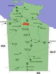
Daly Waters (16°15′12″S 133°22′09″E / 16.25333°S 133.36917°E, 212 metres above sea level) is a small town in the Northern Territory in Australia, about 620 kilometres south of Darwin at the intersection of the Savannah Way and the Stuart Highway.[1]
The area's traditional owners, the Jingili people, believe the Dreaming tracks of the Emu and the Sun travelled through here on their way to the southern parts of the Northern Territory.
History
The name Daly Waters was given to a series of natural springs by John McDouall Stuart during his third attempt to cross Australia from south to north, in 1861-2.[2] Stuart named the springs after the new Governor of South Australia, Sir Dominick Daly.[3]
Stuart's first attempt, in 1860, had reached Tennant Creek. The second, in early 1861, pushed further north but again Stuart turned back. The third journey left Adelaide in October 1861 and reached Daly Waters on 28 May. The party had been pushing through difficult lancewood scrub and harsh terrain at a little over a kilometre a day. This journey was successful, reaching the north coast near modern Darwin on 24 July 1862. Stuart's Tree has an 'S' carved into it by Stuart during his journey.
The Overland Telegraph Line reached Daly Waters from the north in June 1872 and for two months a 'pony express' carried messages the 421 km to Tennant Creek via Renner Springs, Northern Territory.
Daly Waters Airfield was a centre for the London to Sydney air race of 1926, a refuelling stop for early Qantas flights to Singapore, a World War II Airforce base and more recently an operational base for joint military manoeuvres. Although the aerodrome was closed to commercial traffic in 1965 the original Qantas hangar still stands, housing exhibits of photographs and equipment from the area's aviation past.
The traditional owners of the area became the fourth Indigenous group in the Northern Territory to gain native title over both the townsite and ten surrounding pastoral leases covering an area of 30,000 square kilometres (11,583 sq mi). The Australian Federal Court had a special ceremonial sitting on nearby Newcastle Waters Station to commemorate the occasion.[4]
Climate
| Climate data for Daly Waters | |||||||||||||
|---|---|---|---|---|---|---|---|---|---|---|---|---|---|
| Month | Jan | Feb | Mar | Apr | May | Jun | Jul | Aug | Sep | Oct | Nov | Dec | Year |
| Record high °C (°F) | 44.0 (111.2) |
42.0 (107.6) |
40.0 (104) |
38.7 (101.7) |
36.5 (97.7) |
35.3 (95.5) |
34.9 (94.8) |
37.5 (99.5) |
39.5 (103.1) |
41.7 (107.1) |
42.8 (109) |
43.5 (110.3) |
44.0 (111.2) |
| Average high °C (°F) | 36.6 (97.9) |
35.5 (95.9) |
34.6 (94.3) |
33.7 (92.7) |
31.4 (88.5) |
28.7 (83.7) |
28.9 (84) |
31.9 (89.4) |
35.0 (95) |
37.7 (99.9) |
38.4 (101.1) |
38.2 (100.8) |
34.2 (93.6) |
| Average low °C (°F) | 24.0 (75.2) |
23.4 (74.1) |
22.4 (72.3) |
19.3 (66.7) |
15.8 (60.4) |
12.9 (55.2) |
11.8 (53.2) |
13.5 (56.3) |
17.2 (63) |
21.1 (70) |
23.5 (74.3) |
24.0 (75.2) |
19.1 (66.4) |
| Record low °C (°F) | 15.6 (60.1) |
15.6 (60.1) |
14.0 (57.2) |
11.2 (52.2) |
5.0 (41) |
2.1 (35.8) |
2.0 (35.6) |
2.7 (36.9) |
5.2 (41.4) |
11.0 (51.8) |
14.9 (58.8) |
16.0 (60.8) |
2.0 (35.6) |
| Average rainfall mm (inches) | 166.5 (6.555) |
165.2 (6.504) |
117.7 (4.634) |
23.7 (0.933) |
5.0 (0.197) |
5.6 (0.22) |
1.5 (0.059) |
1.7 (0.067) |
4.9 (0.193) |
22.5 (0.886) |
58.1 (2.287) |
110.2 (4.339) |
677.5 (26.673) |
| Average rainy days | 12.2 | 12.0 | 8.3 | 2.5 | 0.6 | 0.5 | 0.3 | 0.2 | 0.7 | 2.8 | 6.1 | 9.9 | 56.1 |
| Source: [5] | |||||||||||||
Gallery
 The Daly Waters "traffic light"
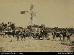 Government Bores, Overland Telegraph (OT) route. Water tanks, windmill, packing up camp onto the buggy.
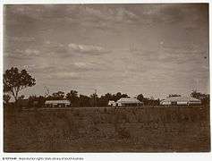 Daly Waters Telegraph Station
Trivia
The main attractions for tourists is the famous pub, which is decorated throughout with banknotes and other memorabilia left by visitors from every corner of the globe. The historic pub was licensed in 1938 to service passengers and crew from the nearby airfield.
A sign at the door of the pub advises that no dogs are allowed, so the owner has a pet miniature pig which is allowed.
Other services are available at the Hi-Way Inn roadhouse, at the junction of the Carpentaria Highway.
References
- ↑ Hema, Maps (2007). Australia Road and 4WD Atlas (Map). Eight Mile Plains Queensland: Hema Maps. p. 96. ISBN 978-1-86500-456-3.
- ↑ "Daly Waters". Sydney Morning Herald. Fairfax Media. 8 February 2004. Retrieved 1 May 2015.
- ↑ "The Journals of John McDouall Stuart". ebooks@Adelaide. Adelaide University. 1858–1862. Retrieved 1 May 2015.
- ↑ "Locals gather to celebrate Native Title ruling". Australian Broadcasting Corporation. 27 June 2012. Retrieved 5 January 2013.
- ↑ "Daly Waters". Climate statistics for Australian locations. Bureau of Meteorology. Retrieved 26 November 2011.
External links
| Wikimedia Commons has media related to Daly Waters, Northern Territory. |