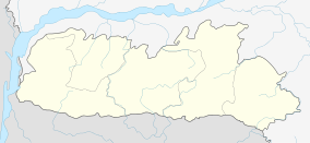
Dalu, Meghalaya
| Dalu | |
|---|---|
| town | |
 Dalu  Dalu Location in Meghalaya, India | |
| Coordinates: 25°13′50″N 90°12′40″E / 25.23056°N 90.21111°ECoordinates: 25°13′50″N 90°12′40″E / 25.23056°N 90.21111°E | |
| Country |
|
| State | Meghalaya |
| District | West Garo Hills |
| Government | |
| • Type | Democracy |
| • Body | Congress |
| Elevation | 16 m (52 ft) |
| Languages | |
| • Official | Garo |
| Time zone | IST (UTC+5:30) |
| Vehicle registration | ML |
| Coastline | 0 kilometres (0 mi) |
| Climate | Am |
Dalu is a village in West Garo Hills district, Meghalaya, India famous for coal export in North East India.
Location
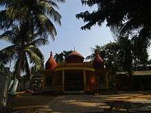
Dalu Mandir
National Highway 51 and National Highway 62 ends at Dalu. Nearest airport is Baljek Airport Baljek, 33 km (21 mi) North-east of Tura in Meghalaya, India.
References
External links
This article is issued from Wikipedia - version of the 9/18/2016. The text is available under the Creative Commons Attribution/Share Alike but additional terms may apply for the media files.