Dallas, South Dakota
| Dallas, South Dakota | |
|---|---|
| Town | |
|
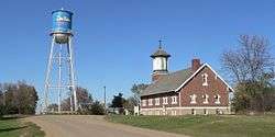
Main Street: water tower and St. Augustine Church | |
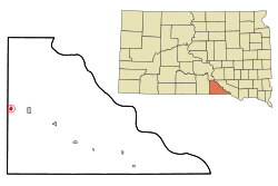 Location in Gregory County and the state of South Dakota | |
| Coordinates: 43°14′13″N 99°31′0″W / 43.23694°N 99.51667°WCoordinates: 43°14′13″N 99°31′0″W / 43.23694°N 99.51667°W | |
| Country | United States |
| State | South Dakota |
| County | Gregory |
| Incorporated | 1908[1] |
| Area[2] | |
| • Total | 0.51 sq mi (1.32 km2) |
| • Land | 0.51 sq mi (1.32 km2) |
| • Water | 0 sq mi (0 km2) |
| Elevation | 2,234 ft (681 m) |
| Population (2010)[3] | |
| • Total | 120 |
| • Estimate (2012[4]) | 121 |
| • Density | 235.3/sq mi (90.8/km2) |
| Time zone | Central (CST) (UTC-6) |
| • Summer (DST) | CDT (UTC-5) |
| ZIP code | 57529 |
| Area code(s) | 605 |
| FIPS code | 46-15300[5] |
| GNIS feature ID | 1254595[6] |
Dallas is a town in Gregory County, South Dakota, United States. The population was 120 at the 2010 census.
History
Dallas was platted in 1907.[7] A post office called Dallas was established in 1904, and remained in operation until it was discontinued in 1973.[8] The town was named after Dallas, Texas.[9]
Geography
Dallas is located at 43°14′13″N 99°31′0″W / 43.23694°N 99.51667°W (43.236820, -99.516582).[10]
According to the United States Census Bureau, the town has a total area of 0.51 square miles (1.32 km2), all of it land.[2]
Dallas has been assigned the ZIP code 57529 and the FIPS place code 15300.
Demographics
| Historical population | |||
|---|---|---|---|
| Census | Pop. | %± | |
| 1910 | 1,277 | — | |
| 1920 | 705 | −44.8% | |
| 1930 | 423 | −40.0% | |
| 1940 | 278 | −34.3% | |
| 1950 | 244 | −12.2% | |
| 1960 | 212 | −13.1% | |
| 1970 | 233 | 9.9% | |
| 1980 | 199 | −14.6% | |
| 1990 | 142 | −28.6% | |
| 2000 | 144 | 1.4% | |
| 2010 | 120 | −16.7% | |
| Est. 2015 | 122 | [11] | 1.7% |
2010 census
As of the census[3] of 2010, there were 120 people, 48 households, and 33 families residing in the town. The population density was 235.3 inhabitants per square mile (90.8/km2). There were 74 housing units at an average density of 145.1 per square mile (56.0/km2). The racial makeup of the town was 85.0% White, 7.5% Native American, 0.8% Asian, 1.7% from other races, and 5.0% from two or more races. Hispanic or Latino of any race were 5.0% of the population.
There were 48 households of which 27.1% had children under the age of 18 living with them, 50.0% were married couples living together, 10.4% had a female householder with no husband present, 8.3% had a male householder with no wife present, and 31.3% were non-families. 27.1% of all households were made up of individuals and 12.6% had someone living alone who was 65 years of age or older. The average household size was 2.50 and the average family size was 3.03.
The median age in the town was 46.5 years. 23.3% of residents were under the age of 18; 7.5% were between the ages of 18 and 24; 18.3% were from 25 to 44; 33.4% were from 45 to 64; and 17.5% were 65 years of age or older. The gender makeup of the town was 53.3% male and 46.7% female.
2000 census
As of the census[5] of 2000, there were 144 people, 59 households, and 38 families residing in the town. The population density was 286.9 people per square mile (111.2/km²). There were 68 housing units at an average density of 135.5 per square mile (52.5/km²). The racial makeup of the town was 90.28% White, 6.94% Native American, 0.69% from other races, and 2.08% from two or more races. Hispanic or Latino of any race were 0.69% of the population.
There were 59 households out of which 28.8% had children under the age of 18 living with them, 52.5% were married couples living together, 6.8% had a female householder with no husband present, and 33.9% were non-families. 25.4% of all households were made up of individuals and 16.9% had someone living alone who was 65 years of age or older. The average household size was 2.44 and the average family size was 2.95.
In the town the population was spread out with 24.3% under the age of 18, 5.6% from 18 to 24, 26.4% from 25 to 44, 22.9% from 45 to 64, and 20.8% who were 65 years of age or older. The median age was 42 years. For every 100 females there were 114.9 males. For every 100 females age 18 and over, there were 98.2 males.
The median income for a household in the town was $17,917, and the median income for a family was $18,906. Males had a median income of $17,813 versus $18,438 for females. The per capita income for the town was $11,970. There were 23.1% of families and 28.3% of the population living below the poverty line, including 31.0% of under eighteens and 32.3% of those over 64.
References
- ↑ "SD Towns" (PDF). South Dakota State Historical Society. Retrieved 2010-02-11.
- 1 2 "US Gazetteer files 2010". United States Census Bureau. Archived from the original on January 24, 2012. Retrieved 2012-06-21.
- 1 2 "American FactFinder". United States Census Bureau. Retrieved 2012-06-21.
- ↑ "Population Estimates". United States Census Bureau. Archived from the original on June 17, 2013. Retrieved 2013-05-29.
- 1 2 "American FactFinder". United States Census Bureau. Archived from the original on September 11, 2013. Retrieved 2008-01-31.
- ↑ "US Board on Geographic Names". United States Geological Survey. 2007-10-25. Retrieved 2008-01-31.
- ↑ Federal Writers' Project (1940). South Dakota place-names, v.1-3. University of South Dakota. p. 32.
- ↑ "Gregory County". Jim Forte Postal History. Retrieved 1 March 2015.
- ↑ Company, Chicago and North Western Railway (1908). A History of the Origin of the Place Names Connected with the Chicago & North Western and Chicago, St. Paul, Minneapolis & Omaha Railways. p. 62.
- ↑ "US Gazetteer files: 2010, 2000, and 1990". United States Census Bureau. 2011-02-12. Retrieved 2011-04-23.
- ↑ "Annual Estimates of the Resident Population for Incorporated Places: April 1, 2010 to July 1, 2015". Retrieved July 2, 2016.
- ↑ "Census of Population and Housing". Census.gov. Archived from the original on May 11, 2015. Retrieved June 4, 2015.
Municipalities and communities of Gregory County, South Dakota, United States | ||
|---|---|---|
| Cities | 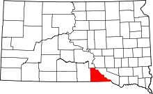 | |
| Towns | ||
| CDP | ||
| Unincorporated communities | ||
| Indian reservation | ||
| Footnotes | ‡This populated place also has portions in an adjacent county or counties | |