Daliyat al-Rawha'
| Daliyat al-Rawha' | |
|---|---|
 Daliyat al-Rawha' | |
| Arabic | دالية الروحاء |
| Name meaning | "The trailing vine of er Rûhah", p.n.[1] |
| Also spelled | Daliyat al Ruha, Daliyat ar Ruha |
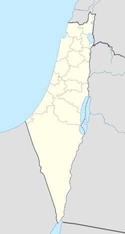
| Subdistrict | Haifa |
| Coordinates | 32°35′28.15″N 35°04′41″E / 32.5911528°N 35.07806°ECoordinates: 32°35′28.15″N 35°04′41″E / 32.5911528°N 35.07806°E |
| Palestine grid | 157/223 |
| Population | 600[2][3] (1945) |
| Area | 10,008[2] dunams |
| Date of depopulation | late March 1948[4] |
| Cause(s) of depopulation | Whispering campaign |
| Secondary cause | Military assault by Yishuv forces |
| Current localities | Ramot Menashe?[5]Daliyya[6] |
Daliyat al-Rawha' (Arabic: دالية الروحاء, Dâliyat er Rûhâ "fragrant vine") was a Palestinian village located 24.5 kilometers (15.2 mi) southeast of Haifa.[7] It was the site of the signing of a ceasefire agreement between the forces of the Mamluks and the Crusaders in the 13th century. A small village of 60 Arab Muslims in the late 19th century, the Jewish colony of Dalia was established on land purchased in the village in 1939. The population in 1945 reached 600 people: 280 Arabs and 320 Jews.[2] It was depopulated of its Arab inhabitants in late March during the 1948 Palestine War.
History
In 1281, the Mamluk sultan Qalawun stayed in Daliyat al-Rawha' while his forces battled against those of the Crusaders. According to Al-Maqrizi, the two sides signed a temporary peace treaty (hudna) in the village.[6]
In 1859 the population was estimated to be about 60, who cultivated 10 faddans of land. In 1882, the Palestine Exploration Fund's Survey of Western Palestine (SWP) described Daliyat al-Rawha' as being a village of moderate size, situated on the west side of a watershed, with a good spring close by on the south.[8]
British Mandate era
In the 1922 census of Palestine conducted by the British Mandate authorities, Dalia al-Ruha had a population 135, all Muslims,[9] increasing in the 1931 census to 163, still all Muslim, in a total of 46 houses.[10]
The villagers also raised livestock. The village had a rectangular layout from east to west. The houses were grouped closely together and made of stone, held together with mud or cement. The main water sources for the village were located nearby.[6]
By the 20th century, the Arabs of Daliyat al-Rawha were tenant farmers.[11] The Palestine Jewish Colonization Association (PICA) purchased 10,073 dunams of land in Daliyat al-Rawha and neighboring Umm ed-Dafuf (now Kibbutz Dalia) in 1936.[12] The Jewish colony of Dalia was established in 1939 to the south of the built up area of Daliyat al-Rawha' on village lands.[6]
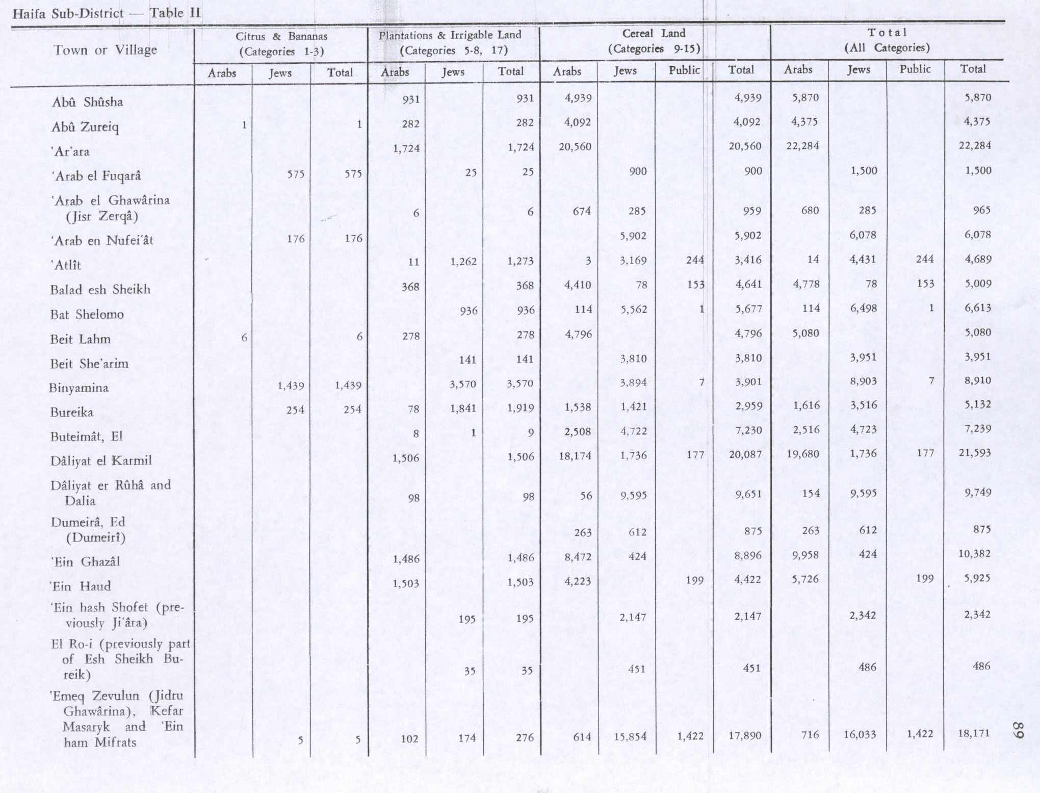
In 1945 the population was 280 Arabs, and a total of 10,008 dunams of land, most of it Jewish owned, according to an official land and population survey.[2][3] 98 dunams were for plantations and irrigable land, 56 for cereals,[13] while 24 dunams were built-up (urban) land.[14]
Types of land use in dunams in the village in 1945:[13][14]
| Land Usage | Arab | Jewish |
|---|---|---|
| Irrigated and plantation | 98 | 0 |
| Cereal | 56 | 9,595 |
| Urban | 24 | 19 |
| Cultivable | 154 | 9,595 |
The land ownership of the village before occupation in dunams:[2]
| Owner | Dunams |
|---|---|
| Arab | 178 |
| Jewish | 9,614 |
| Public | 216 |
| Total | 10,008 |
1948 war and aftermath
Benny Morris relates that Yosef Weitz was concerned with the problem posed by Arab tenant farmers in the area as early as January 1948. A diary entry Weitz made following a meeting with officials of the Jewish National Fund states:
"Is not now the time to be rid of them [he was referring specifically to the tenant farmers in Yoqne'am and Daliyat ar Ruha]? Why continue to keep in our midst these thorns at a time when they pose a danger to us? Our people are considering [solutions]."[15]
In March 1948, Weitz organized with the Jewish settlers of Kibbutz Kfar Masaryk to evict the tenant communities at Daliyat al-Rawha' and Buteimat.[15]
The New York Times reports the village was captured on April 14, 1948, during the Battle of Mishmar HaEmek.[6] By mid-June 1948, according to David Ben-Gurion as based on a report written by Weitz, Daliyat al-Rawha' had been destroyed by the Israeli authorities, while the destruction of Buteimat and Sabbarin was about to begin.[16] According to Morris, Ramot Menashe was established on the village lands almost immediately thereafter.[5] Khalidi writes that Ramot Menashe is actually located on the lands of neighboring Sabbarin.[6]
In 1995, a committee representing internally displaced Palestinians from Daliyat al-Rawha' joined the Association for the Defense of the Rights of the Internally Displaced (ADRID), a national committee in Israel that advocates for these internal refugees' right of return.[17]
References
- ↑ Palmer, 1881, p. 146
- 1 2 3 4 5 Government of Palestine, Department of Statistics. Village Statistics, April, 1945. Quoted in Hadawi, 1970, p. 47.
- 1 2 Department of Statistics, 1945, p. 13
- ↑ Morris, 2004, p. xviii, village #162. Also gives causes of depopulation.
- 1 2 Morris, 2004, p. xx, settlement #4.
- 1 2 3 4 5 6 Khalidi, 1992, p. 158.
- ↑ Khalidi, 1992, p. 157.
- ↑ Conder and Kitchener, 1882, SWP II, p. 41. Also cited in Khalidi, 1992, p. 158
- ↑ Barron, 1923, Table xi, Sub-district of Haifa, p. 34
- ↑ Mills, 1932, p. 89
- ↑ Morris, 2004, p. 372
- ↑ Avneri, 1984, p. 220
- 1 2 Government of Palestine, Department of Statistics. Village Statistics, April, 1945. Quoted in Hadawi, 1970, p. 89
- 1 2 Government of Palestine, Department of Statistics. Village Statistics, April, 1945. Quoted in Hadawi, 1970, p. 139
- 1 2 Morris, 2004, pp. 131-2
- ↑ Morris, 2004, p. 350
- ↑ Masalha, ed., 2005, p. 99
Bibliography
- Avneri, Arieh L. (1984). The Claim of Dispossession: Jewish Land-settlement and the Arabs, 1878-1948. Transaction Publishers. ISBN 0-87855-964-7.
- Barron, J. B., ed. (1923). Palestine: Report and General Abstracts of the Census of 1922. Government of Palestine.
- Conder, Claude Reignier; Kitchener, H. H. (1882). The Survey of Western Palestine: Memoirs of the Topography, Orography, Hydrography, and Archaeology. 2. London: Committee of the Palestine Exploration Fund.
- Department of Statistics (1945). Village Statistics, April, 1945. Government of Palestine.
- Hadawi, Sami (1970). Village Statistics of 1945: A Classification of Land and Area ownership in Palestine. Palestine Liberation Organization Research Center.
- Khalidi, Walid (1992). All That Remains: The Palestinian Villages Occupied and Depopulated by Israel in 1948. Washington D.C.: Institute for Palestine Studies. ISBN 0-88728-224-5.
- Masalha, Nur-eldeen (2005). Catastrophe remembered: Palestine, Israel and the internal refugees : essays in memory of Edward W. Said (1935-2003). Zed Books. ISBN 978-1-84277-623-0.
- Mills, E., ed. (1932). Census of Palestine 1931. Population of Villages, Towns and Administrative Areas (PDF). Jerusalem: Government of Palestine.
- Morris, Benny (2004). The Birth of the Palestinian Refugee Problem Revisited. Cambridge University Press. ISBN 978-0-521-00967-6.
- Palmer, E. H. (1881). The Survey of Western Palestine: Arabic and English Name Lists Collected During the Survey by Lieutenants Conder and Kitchener, R. E. Transliterated and Explained by E.H. Palmer. Committee of the Palestine Exploration Fund.
External links
- Welcome To Daliyat al-Rawha'
- Survey of Western Palestine, Map 8: IAA, Wikimedia commons
- Daliyat al-Rawha' from the Khalil Sakakini Cultural Center