Dale River
| Dale | |
| River | |
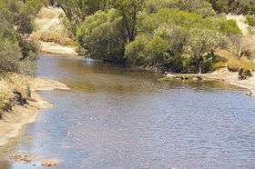 Avondale Agricultural Research Station, Dale River | |
| Name origin: Robert Dale, an explorer | |
| Country | Australia |
|---|---|
| State | Western Australia |
| Region | Wheatbelt |
| Part of | Avon River |
| Source | Darling Scarp |
| - location | Boyagarring Conservation Reserve |
| - elevation | 374 m (1,227 ft) |
| - coordinates | 32°18′56″S 116°25′27″E / 32.31556°S 116.42417°E |
| Mouth | Avon River |
| - location | west of Beverley |
| - elevation | 189 m (620 ft) |
| - coordinates | 32°4′17″S 116°50′2″E / 32.07139°S 116.83389°ECoordinates: 32°4′17″S 116°50′2″E / 32.07139°S 116.83389°E |
| Length | 75 km (47 mi) |
| [1][2] | |
The Dale River is a perennial river located in the Wheatbelt region of Western Australia.
Rising on the eastern slopes of the Darling Scarp, the river flow generally east by north, joined by six major tributaries including the Dale River South, Gibb Gully, Connelly Gully, Sherlock Gully, Flint Gully and Talbot Brook. The river reaches its mouth to join the Avon River approximately 10 kilometres (6.2 mi) west of Beverley near the Avondale Agricultural Research Station. The river descends 185 metres (607 ft) over its 75-kilometre (47 mi) course.
The Dale River was named in honour of Robert Dale, the first European explorer to venture into the Darling Ranges in 1829.
See also
References
- ↑ Western Australian Land Information Authority. "History of river names". Archived from the original on 16 February 2015. Retrieved 3 September 2011.
- ↑ "Map of Dale River, WA". Bonzle Digital Atlas. 2008. Retrieved 23 November 2008.
Rivers of Western Australia | |
|---|---|
| Rivers of the Gascoyne region | |
| Rivers of the Goldfields-Esperance region | |
| Rivers of the Great Southern region | |
| Rivers of the Kimberley region |
|
| Rivers of the Mid West region | |
| Rivers of the Peel and Perth regions (and streams) | |
| Rivers of the Pilbara region | |
| Rivers of the South West region | |
| Rivers of the Wheatbelt region | |
| |
This article is issued from Wikipedia - version of the 9/16/2016. The text is available under the Creative Commons Attribution/Share Alike but additional terms may apply for the media files.