Dajia River
| Dajia River | |
|---|---|
 | |
| Native name | 大甲溪 |
| Country | Taiwan |
| Basin | |
| Main source |
Nanhu Mountain 3,637 metres (11,932 ft) |
| River mouth | Taiwan Strait |
| Basin size | 1,235.73 square kilometres (477.12 sq mi) |
| Physical characteristics | |
| Length | 124.20 kilometres (77.17 mi) |
| Discharge |
|


Dajia River (Chinese: 大甲溪; pinyin: Dàjiǎ Xī; Pe̍h-ōe-jī: Tāi-kah-khoe; literally: "big shell river") is a river in north-central Taiwan. It flows through Taichung City for 124 km.[1] The sources of the Dajia are: Hsuehshan and Nanhu Mountain in the Central Mountain Range.[2] The Dajia River flows through the Taichung City districts of Heping, Xinshe, Dongshi, Shigang, Fengyuan, Houli, Shengang, Waipu, Dajia, Qingshui, and Da'an before emptying into the Taiwan Strait.[2]
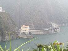
The Deji Reservoir (德基水庫; Déjī Shuǐkù; "virtuous foundation reservoir"), formed by Techi Dam, is a 592-hectare reservoir in Dajia District.[3] The reservoir provides municipal water, generates hydroelectric power, is used for recreation and prevents flooding.[3] Techi and a cascade of five other dams on the Dajia produce up to 1,100 megawatts of hydroelectric power and generate more than 2.4 billion KWh per year.[4] The other five dams in sequence from top hill are Qingshan Dam, Kukuan Dam, Tienlun Dam, Ma'an Dam and Shihgang Dam.
Taiwan's Central Cross-Island Highway runs along the Dajia River from Heping to Dongshih. The Taichung Beltway begins in Fongyuan and follows the Dajia through into Cingshuei.
Incidents
The Dajia experiences frequent earthflows during typhoons and heavy rain, damaging homes and breaking up roads, sometimes permanently. In September 2008, rains from Typhoon Sinlaku resulted in storm-swollen waters which washed away supports for a section of Houfeng Bridge (which links Houli Township and Fengyuan City), leaving six people dead.[5] In June 2010, the bridge finally reopened to vehicular traffic after over NT$1.4 billion of reconstruction work.[6]
See also
References
- ↑ Philip Diller. "Taiwan Rivers and Watersheds". Retrieved 2007-11-30.
- 1 2 "大安大甲流域(Da-an/Dajia River Basin)" (in Chinese). Retrieved 2007-11-30.
- 1 2 "德基水庫(Techi Reservoir)" (in Chinese). National Taiwan Ocean University Water Resource Management Center. Retrieved 2007-11-30.
- ↑ 大甲溪 (PDF) (in Chinese). Taiwan Water Resources Agency. 2009-01-22. Archived from the original (PDF) on 2011-08-15. Retrieved 2013-06-25.
- ↑ "Typhoon wreaks havoc during festival". Taiwan Today. 2008-09-19. Retrieved 2010-07-10.
- ↑ "Traffic resumes on Taichung's Houfeng Bridge". The China Post. 2010-06-30. Retrieved 2010-07-10.
Coordinates: 24°20′00″N 120°33′23″E / 24.3333°N 120.5564°E