Daisy Geyser
| Daisy Geyser | |
|---|---|
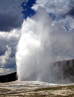
 Daisy Geyser during an eruption | |
| Name origin | Hague Geological Surveys, 1880s |
| Location | Upper Geyser Basin, Yellowstone National Park, Teton County, Wyoming |
| Coordinates | 44°28′12″N 110°50′42″W / 44.4699327°N 110.8449336°WCoordinates: 44°28′12″N 110°50′42″W / 44.4699327°N 110.8449336°W[1] |
| Elevation | 7,339 feet (2,237 m) [2] |
| Type | Cone geyser |
| Eruption height | 60-75 feet |
| Frequency | 120 to over 200 minutes |
| Duration | 3-4 minutes |
| Temperature | 84.5 °C (184.1 °F) [1] |
 Map of Upper Geyser Basin | |
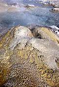
Daisy Geyser is a geyser in the Upper Geyser Basin of Yellowstone National Park in the United States.
Daisy Geyser is part of the Daisy Group. It was named prior to 1890 by the Hague Party.[3] It erupts every 110 to 240 minutes for a period of 3 to 5 minutes and is one of the most predictable geysers in the park. Its fountain erupts at an angle to the ground and reaches a height of 75 feet (23 m).[4] The interval between eruptions can be temporarily altered by an eruption of nearby Splendid Geyser. To a smaller degree, Brilliant Pool and Comet Geyser are influenced by Splendid and Daisy.[5]
Daisy Geyser was one of the Yellowstone geysers that had its eruption interval disrupted by the 2002 Denali earthquake, in Alaska. Immediately after the quake, the interval rapidly decreased but returned to previous intervals over the course of a few weeks.[6]
| Images of Daisy Geyser | ||
|---|---|---|
|
References
- 1 2 "Daisy Geyser". Yellowstone Geothermal Features Database. Montana State University.
- ↑ "Daisy Geyser". Geographic Names Information System. United States Geological Survey.
- ↑ Bauer, Clyde Max (1947). Yellowstone Geysers. Yellowstone Park, Wyoming: Haynes. OCLC 1517713.
- ↑ "Daisy Geyser". Predicting Geysers. National Park Service.
- ↑ "Daisy Geyser". The Geyser Observation and Study Association.
- ↑ Husen S; Taylor R; Smith RB; Healser H (2004). "Changes in geyser eruption behavior and remotely triggered seismicity in Yellowstone National Park produced by the 2002 M 7.9 Denali fault earthquake, Alaska". Geology. 32 (6): 537–540. doi:10.1130/G20381.1.
Yellowstone National Park - Upper Geyser Basin | ||
|---|---|---|
Geothermal features and other attractions in the Upper Geyser Basin | ||
| Geysers |
|  |
| Hot Springs | ||
| Lone Star Geyser Basin | ||
| Structures and History | ||
| Geography | ||
| ||
Cheyenne (capital) | |
| Topics |
|
| Society |
|
| Regions | |
| Cities | |
| Counties | |