Dahme-Spreewald
Dahme-Spreewald (Lower Sorbian: Damna-Błota) is a district in Brandenburg, Germany. It is bounded by (from the east and clockwise) the districts of Oder-Spree, Spree-Neiße, Oberspreewald-Lausitz, Elbe-Elster and Teltow-Fläming, and by the city of Berlin.
History
The Spreewald region has always been a centre of Sorbian culture. In medieval times the cities of Lübben and Luckau had successively been capitals of the margravate of Lower Lusatia. From 1815 on Lower Lusatia was a part of Prussia. Throughout the 19th century the region remained an agriculturally used area, some urbanisation taking place in the very north (close to Berlin) only.
When the state of Brandenburg was newly founded in 1990, the districts of Lübben, Luckau and Königs Wusterhausen had been established. In 1993 the three districts were merged.
Geography
The Spree river enters the district in the southeast and leaves to the northeast. The wooded regions along its banks are called Spreewald. The Spreewald is the westernmost part of Lusatia. Especially the cities of Lübben and Lübbenau welcome many tourists each year, offering boat trips and relaxing holidays in the beautiful Spreewald nature.
The Dahme river is a tributary of the Spree. It forms many lakes in the northern part of the district. The Dahme leaves the district towards Berlin, where it is occasionally used for boat races. Eventually, it joins the Spree.
Demography
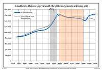
Development of Population since 1875 within the Current Boundaries (Blue Line: Population; Dotted Line: Comparison to Population Development of Brandenburg state; Grey Background: Time of Nazi rule; Red Background: Time of Communist rule)
Recent Population Development (Blue Line) and Forecasts
Landkreis Dahme-Spreewald:
Population development within the current boundaries[2]
| Year |
Population |
|
|
|---|
| 1875 | 83 381 |
| 1890 | 87 772 |
| 1925 | 109 281 |
| 1933 | 120 359 |
| 1939 | 137 972 |
| 1946 | 162 990 |
| 1950 | 161 884 |
| 1964 | 151 847 |
| 1971 | 151 350 |
| 1981 | 148 279 |
|
|
| Year |
Population |
|
|
|---|
| 1985 | 147 508 |
| 1989 | 144 791 |
| 1990 | 142 899 |
| 1991 | 140 836 |
| 1992 | 141 714 |
| 1993 | 141 701 |
| 1994 | 142 819 |
| 1995 | 144 990 |
| 1996 | 147 871 |
| 1997 | 150 995 |
|
|
| Year |
Population |
|
|
|---|
| 1998 | 154 894 |
| 1999 | 157 341 |
| 2000 | 158 994 |
| 2001 | 159 568 |
| 2002 | 159 923 |
| 2003 | 160 173 |
| 2004 | 161 179 |
| 2005 | 161 937 |
| 2006 | 161 756 |
| 2007 | 161 699 |
|
|
| Year |
Population |
|
|
|---|
| 2008 | 161 482 |
| 2009 | 161 708 |
| 2010 | 161 805 |
| 2011 | 160 108 |
| 2012 | 160 314 |
|
|
Detailed data sources are to be found in the Wikimedia Commons.[3]
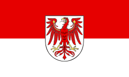
Coat of arms
 |
The coat of arms displays:
- top left: the bull is the heraldic animal of Lusatia
- top right: the eagle is the heraldic animal of Brandenburg
- bottom: the crown symbolises the former hunting lodge of the Prussian kings, which was in Königs Wusterhausen
|
Towns and municipalities
References
External links
 Urban and rural districts in the state of Brandenburg in Germany  |
|---|
|
| Urban districts | |
|---|
|
| Rural districts | |
|---|
Coordinates: 52°2′N 13°54′E / 52.033°N 13.900°E / 52.033; 13.900

 Development of Population since 1875 within the Current Boundaries (Blue Line: Population; Dotted Line: Comparison to Population Development of Brandenburg state; Grey Background: Time of Nazi rule; Red Background: Time of Communist rule)
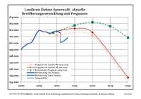 Recent Population Development (Blue Line) and Forecasts