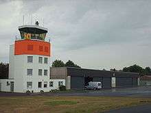
Dahlemer Binz Airfield
| Dahlemer Binz Airfield Flugplatz Dahlemer Binz | |||||||||||
|---|---|---|---|---|---|---|---|---|---|---|---|
 | |||||||||||
| IATA: none – ICAO: EDKV | |||||||||||
| Summary | |||||||||||
| Airport type | Public | ||||||||||
| Operator | Flugplatzgesellschaft Dahlemer Binz GmbH | ||||||||||
| Location | Dahlem, North Rhine-Westphalia, Germany | ||||||||||
| Opened | 1957 | ||||||||||
| Elevation AMSL | 578 m / 1,896 ft | ||||||||||
| Coordinates | 50°24′20″N 006°31′44″E / 50.40556°N 6.52889°ECoordinates: 50°24′20″N 006°31′44″E / 50.40556°N 6.52889°E | ||||||||||
| Map | |||||||||||
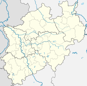 Dahlemer Binz Airfield Location in North Rhine-Westphalia | |||||||||||
| Runways | |||||||||||
| |||||||||||
Dahlemer Binz Airfield (German: Flugplatz Dahlemer Binz) is a public general aviation airfield in the Eifel mountains of Germany. It is located in the municipality of Dahlem, about 35 kilometres southwest of Euskirchen.
The airfield is licensed for:
- Powered aircraft (incl. helicopters) up to 5,700 kg flying weight (Fluggewicht)
- Motor gliders
- Gliders, both winched and towed
- Microlights
- Hot air balloons
- Parachuting
Weblinks
This article is issued from Wikipedia - version of the 3/11/2016. The text is available under the Creative Commons Attribution/Share Alike but additional terms may apply for the media files.