Dafni, Attica
| Dafni Δάφνη | |
|---|---|
 Dafni | |
|
Location within Athens 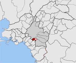 | |
| Coordinates: 37°57′N 23°44′E / 37.950°N 23.733°ECoordinates: 37°57′N 23°44′E / 37.950°N 23.733°E | |
| Country | Greece |
| Administrative region | Attica |
| Regional unit | Central Athens |
| Municipality | Dafni-Ymittos |
| • Municipal unit | 1.375 km2 (0.531 sq mi) |
| Elevation | 80 m (260 ft) |
| Population (2011)[1] | |
| • Municipal unit | 22,913 |
| • Municipal unit density | 17,000/km2 (43,000/sq mi) |
| Time zone | EET (UTC+2) |
| • Summer (DST) | EEST (UTC+3) |
| Postal code | 172 xx |
| Area code(s) | 210 |
| Website | www.dimosdafnis.gr |
Dafni (Greek: Δάφνη) is a suburb of Athens, Greece. Since the 2011 local government reform it is part of the municipality Dafni-Ymittos, of which it is the seat and a municipal unit.[2]
Geography
Dafni is an inner suburb of Athens, 2 km south of the Acropolis of Athens. Its built-up area is continuous with that of Athens and the surrounding suburbs Nea Smyrni, Agios Dimitrios and Ymittos. Dafni metro station is served by Line 2 of the Athens Metro. The main thoroughfare is Vouliagmenis Avenue, which connects Dafni with Athens city centre. At 1.375 km²[3] it is one of the smallest municipal units in the Athens metropolitan area.
Sports
The Amyntas Dafnis HEBA basketball club (A2 Division) competes at the Dafni Indoor Hall.

Nighttime scene of Kalogyrous Square, Dafni, Athens, Greece
References
- ↑ "Απογραφή Πληθυσμού - Κατοικιών 2011. ΜΟΝΙΜΟΣ Πληθυσμός" (in Greek). Hellenic Statistical Authority.
- ↑ Kallikratis law Greece Ministry of Interior (Greek)
- ↑ "Population & housing census 2001 (incl. area and average elevation)" (PDF) (in Greek). National Statistical Service of Greece.
External links
- Official website (Greek)
This article is issued from Wikipedia - version of the 12/4/2016. The text is available under the Creative Commons Attribution/Share Alike but additional terms may apply for the media files.