D120 road (Croatia)
| |
|---|---|
| Route information | |
| Length: | 42.9 km (26.7 mi) |
| Major junctions | |
| From: | Pomena |
|
| |
| To: | Saplunara |
| Location | |
| Counties: | Dubrovnik-Neretva |
| Highway system | |
| State roads in Croatia | |


Pomena, at the western terminus of the D120 road
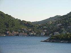
Sobra, on the D120 road route
D120 is the main state road on island of Mljet in Croatia connecting Mljet National Park and resorts on the island to Sobra and the ferry port in the town, from where Jadrolinija ferries sail to the mainland, docking in Prapratno and the D416 state road.[1] The road is 42.9 km (26.7 mi) long.[2]
The road, as well as all other state roads in Croatia, is managed and maintained by Hrvatske ceste, a state-owned company.[3]
Traffic volume
Traffic is regularly counted and reported by Hrvatske ceste (HC), operator of the road.[4] Substantial variations between annual (AADT) and summer (ASDT) traffic volumes are attributed to the fact that the road connects a number of island resorts to the mainland.
| D120 traffic volume | ||||
| Road | Counting site | AADT | ASDT | Notes |
| |
6504 Babino Polje | 308 | 646 | Adjacent to the D123 junction. |
Road junctions and populated areas
| D120 junctions/populated areas | |
| Type | Slip roads/Notes |
| |
Pomena The western terminus of the road. |
| |
Polače |
| |
L69037 to Blato and Kozarica. |
| |
Babino Polje |
| |
Sobra |
| |
Prožura |
| |
Maranovići L69070 to Okuklje. |
| |
Saplunara The eastern terminus of the road. |
Sources
- 1 2 "Jadrolinija ferry service". May 11, 2010.
- ↑ "Decision on categorization of public roads as state roads, county roads and local roads". Narodne novine (in Croatian). February 17, 2010.
- ↑ "Public Roads Act". Narodne novine (in Croatian). December 14, 2004.
- ↑ "Traffic counting on the roadways of Croatia in 2009 – digest" (PDF). Hrvatske ceste. May 1, 2010. Archived from the original (PDF) on July 21, 2011.
This article is issued from Wikipedia - version of the 9/13/2016. The text is available under the Creative Commons Attribution/Share Alike but additional terms may apply for the media files.