Dera Ismail Khan
| Dera Ismail Khan ڈیرہ اسماعیل خان | |
|---|---|
 | |
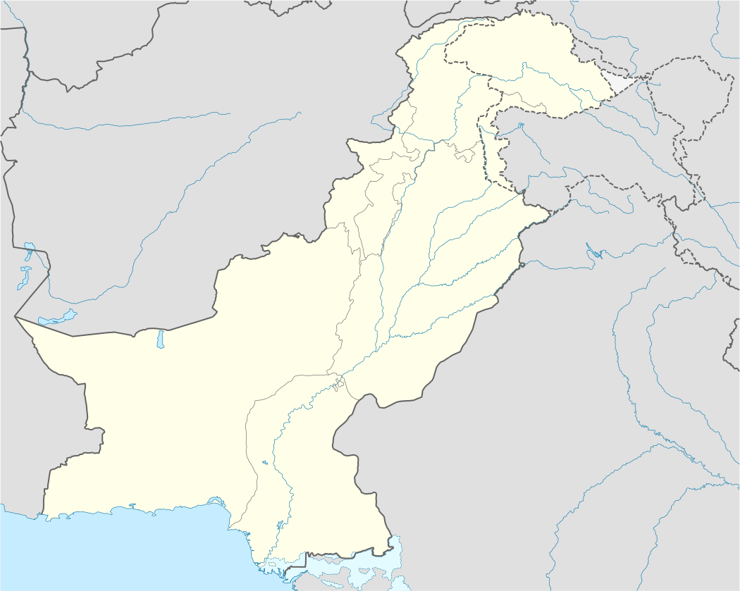 Dera Ismail Khan District map of Pakistan. Dera Ismail Khan district is maroon colored and other Pakhtunkhwa districts are in white. | |
| Coordinates: 31°49′N 70°55′E / 31.817°N 70.917°ECoordinates: 31°49′N 70°55′E / 31.817°N 70.917°E | |
| Country |
|
| Province | Khyber-Pakhtunkhwa Province |
| Government | |
| • DC DIKhan | Mr. Nisar Ahmad |
| Elevation | 165 m (541 ft) |
| Time zone | PST (UTC+5) |
| Number of union councils | 47 |
Dera Ismail Khan (Urdu : ڈیرہ اسماعیل خان, Pashto: ډېره اسماعيل خان), often abbreviated to D.I. Khan,[1] is a city in Khyber-Pakhtunkhwa Province, Pakistan. It is situated on the west bank of the Indus River, 200 miles (320 km) west of Lahore and 120 miles (190 km) northwest of Multan.[2] The city is the capital of the district and tehsil of the same name. The total population of the city is 86,969 according to census 1998. D.I.Khan is famous for its lacquered woodwork, glass and ivory ware, mats and sarongs. Newer industries within the city include sugar, soap, textile and oil milling. CRBC Canal is the major canal that provides water for irrigation. One of the most famous product of the district is the "Dhakki Date", which is exported to the Middle East, United States, and Europe. The district also produces wheat, sugar cane, rice and famous variety of mango called the langra.
History
Etymology
The word "Dera" is derived from the balochi word ḍerā which means "encampment".[3] This word is commonly used for residential towns in the Indus valley such as Dera Ghazi Khan, Dera Bugti, Dera Murad Jamali, Dera Allah Yar, Dera Ismail Khan, etc. Dera Ismail Khan thus means the residential town of Sardar Ismail Khan Baloch. People of Dera Ismail Khan as well as Dera Ghazi Khan are also known as Derawal or sometimes as Dervi while the latter is used as Pen name or Takhallus. Historically the Derajat were established at the time when in the 15th century, Baloch tribal immigration took place from Makran, Qalat.chagi and Sibi Balochistan, to Indus Valley. Sultan Husain, the Langah Dynasty's Sultans of Multan, being unable to hold his trans-Indus possessions; called the Baloch tribal warriors, for help and assigned these territories to Sardar Malik Sohrab Khan Dodai Baloch as "Jagir". Sohrab's sons, Ghazi Khan, Ismail khan and Fateh Khan, founded the three Deras or villages' named after them.
Foundation of the city
The Delhi Sultanate and later Mughal Empire ruled the region. The Multan region became predominantly Muslim due to missionary Sufi saints whose dargahs dot the landscape of Khyber-Pakhtunkhwa. Dera Ismail Khan was founded toward the end of the fifteenth century by Sardar Ismail Khan Baloch, a son of Sardar Malik Sohrab Khan Dodai Baloch, who named the town after himself. The original town was swept away by a flood in 1823, and the existing buildings are all of relatively modern construction.[2] The present town stands four miles (6 km) back from the permanent channel of the river.[4]
Foundation of the new city
However, later research does not support this theory. Firstly, Malik Sohrab was not an Arab adventurer but a Hooth Baloch who was appointed Subahdar of this area by the Langha rulers of Multan. Similarly the city could not have been founded towards the end of fifteenth century; because when Babar came here in 1506 he passed through this plain which is now called Dama'an and referred to it as Dasht and went up to Tank but did not mention any city around here in his Tuzk (Memoirs, originally published in Turkish). Later we are told that when in 1540 Sher Shah came to Khushab, Ismail Khan of Dera Ismail Khan went to Khushab to meet him there. So the city must have been founded in the first quarter of the sixteenth century.[5] After the flood destruction of 1823, the present city was founded by Nawab Sher Muhammad Khan Sadozai in 1825, but he preferred to retain the old name for it.
British era
During British rule the town contained two bazaars, the Hindu and Muslim population living in separate quarters. The town stands on a level plain, with a slight fall to the river, but is badly drained. It is surrounded by a thin mud wall, with nine gates, enclosing an area of about 500 acres (2.0 km2). The cantonment, which lies southeast of the town, has an area of 44 square miles (110 km2), excluding the portion known as Fort Akalgarh on the northwest side. The civil lines are to the south.[2] The Derajat Brigade had its winter headquarters at Dera Ismail Khan, and the garrison consisted of a mountain battery, a regiment of Native cavalry, and three regiments of Native infantry. Detachments from these regiments helped to garrison the outposts of Drazinda, Jandola, and Jatta. The municipality was constituted in 1867. The income during the ten years ending 1902–3 averaged Rs. 55,000, and the expenditure Rs. 53,000. The income and expenditure in 1903-4 were Rs. 55,500 and Rs. 55,800 respectively. The chief source of income was octroi (Rs. 48,000); the chief items of expenditure were conservancy (Rs. 8,785), education (Rs. 7,246), hospitals and dispensaries (Rs. 6,302), public safety (Rs. 7,733), public works (Rs. 2,143), and administration (Rs. 5,546). The receipts and expenditure of cantonment funds during the ten years ending 1902–3 averaged RS. 2,700 and Rs. 2,800 respectively.[2]
The local trade of Dera Ismail Khan was of second-rate importance, but some foreign traffic with Khorasan passed through it. Powinda caravans of Afghan merchants traversed the town twice a year on their road to and from India; and, with the increasing security of the Gomal route, these caravans were yearly swelling in numbers. The chief imports were English and native piece-goods, hides, salt, and fancy wares; and the exports, grain, wood, and ghee. The local manufactures are lungis and lacquered woodwork. The town possesses a civil hospital; its chief educational institutions are two aided Anglo-vernacular high schools, one maintained by the Church Missionary Society and the other by the Bharatri Sabha, and an Anglo-vernacular middle school maintained by the municipality.[2]
The predominantly Muslim population supported Muslim League and Pakistan Movement. After the independence of Pakistan in 1947, the minority Hindus and Sikhs migrated to India while the Muslims refugees from India settled down in the Dera Ismail Khan.
Climate
Dera Ismail Khan has a (Köppen climate classification BWh) with hot summers and mild winters. Precipitation mainly falls in two distinct periods: in the late winter and early spring from February to April, and in the monsoon in June and July.
| Climate data for Dera Ismail Khan | |||||||||||||
|---|---|---|---|---|---|---|---|---|---|---|---|---|---|
| Month | Jan | Feb | Mar | Apr | May | Jun | Jul | Aug | Sep | Oct | Nov | Dec | Year |
| Record high °C (°F) | 28.9 (84) |
30.6 (87.1) |
37.2 (99) |
43.3 (109.9) |
47.9 (118.2) |
48.9 (120) |
47.0 (116.6) |
44.5 (112.1) |
42.4 (108.3) |
40.5 (104.9) |
35.0 (95) |
30.6 (87.1) |
48.9 (120) |
| Average high °C (°F) | 20.3 (68.5) |
22.1 (71.8) |
26.9 (80.4) |
33.5 (92.3) |
38.7 (101.7) |
41.5 (106.7) |
38.5 (101.3) |
37.4 (99.3) |
36.7 (98.1) |
33.4 (92.1) |
27.7 (81.9) |
21.9 (71.4) |
31.55 (88.79) |
| Daily mean °C (°F) | 12.2 (54) |
14.7 (58.5) |
19.9 (67.8) |
26.0 (78.8) |
30.9 (87.6) |
34.2 (93.6) |
32.7 (90.9) |
31.9 (89.4) |
30.2 (86.4) |
25.3 (77.5) |
19.1 (66.4) |
13.6 (56.5) |
24.23 (75.62) |
| Average low °C (°F) | 4.2 (39.6) |
7.3 (45.1) |
12.9 (55.2) |
18.5 (65.3) |
23.1 (73.6) |
26.8 (80.2) |
26.9 (80.4) |
26.4 (79.5) |
23.8 (74.8) |
17.3 (63.1) |
10.5 (50.9) |
5.3 (41.5) |
16.92 (62.43) |
| Record low °C (°F) | −2.2 (28) |
−2.0 (28.4) |
4.0 (39.2) |
9.5 (49.1) |
14.4 (57.9) |
17.5 (63.5) |
18.6 (65.5) |
19.5 (67.1) |
15.8 (60.4) |
8.0 (46.4) |
2.2 (36) |
−2.8 (27) |
−2.8 (27) |
| Average precipitation mm (inches) | 10.0 (0.394) |
17.5 (0.689) |
34.8 (1.37) |
21.7 (0.854) |
17.2 (0.677) |
14.4 (0.567) |
60.8 (2.394) |
57.5 (2.264) |
17.6 (0.693) |
4.8 (0.189) |
2.1 (0.083) |
10.4 (0.409) |
268.8 (10.583) |
| Mean monthly sunshine hours | 222.2 | 206.8 | 234.3 | 259.2 | 290.1 | 247.7 | 241.3 | 261.1 | 271.1 | 283.2 | 249.7 | 220.4 | 2,987.1 |
| Source: NOAA (1961-1990) [6] | |||||||||||||
Language
Saraiki, is main spoken language spoken in Dera Ismail Khan. Pashto is spoken in old areas. Balochi are spoken by some tribes of Balochs.
Politics
Dera Ismail Khan is represented in the National Assembly of Pakistan through two seats which are NA-24 (D I Khan) and NA-25 (D I Khan cum Tank). The incumbent on these both seats NA-24 Maulana Fazal ur Rehman of Jamiat Ullema Islam- Fazal ur Rehman (JUI-F) popular as Ameer Shariat. Traditionally Dera politics has been dominated by Moulana Fazl ur Rehman due to low literacy rate. Maulana Fazl ur Rehman lost last elections to PPP candidate with a wide margin which shows that they have lost connection with voters but in 2014 Elections Molana Fazul-ur-Rehman bounce back and win NA-24 seat. Another party PTI rise to fame in D.I.Khan in 2014 and PTI candidate Ali Amin Khan Gandapur win the PK-64 seat with a huge margin. ( 1. Ali Amin Khan, Pakistan Tehreek-e-Insaf, 14047 votes. 2. Moulana Lutfur Rehman Jamiat Ulama-e-Islam (F) 12678 votes. The huge margin is 1369 votes). In recent local bodies election independent observers highlighted incidents on massive rigging by the ruling party of the province to ensure success of the candidates fielded by them, the most controversial incident was the snatching of ballot boxes by Ali Amin Khan Gandapur from a polling station which resulted in a major stand off between the general public and Gandapur who currently serves in the provincial cabinet of PTI government. A notable figure of Dera Ismail Khan's political arena Malik Arif Jalil, brother of the slain ex-nazim Advocate Iftikhar Saleem is currently contesting the results of the local bodies election in relation vote count in certain polling stations where the altercations induced by Gandapur took place. Many credible critics have viewed this to be the most prolific and sought after action by a political opponent of the PTI government in Dera Ismail Khan, Malik Arif Jaleel was the candidate in field for JUI-F and is widely admired and commended for his social work by the concerned segments of the society and also enjoys the unflinching support of his party. Prior to the results of the polls many sources declared Malik Arif Jaleel as the clear winner, however, due to dubious circumstances the final result was contrary to earlier reports. [7]
Recent acts of violence
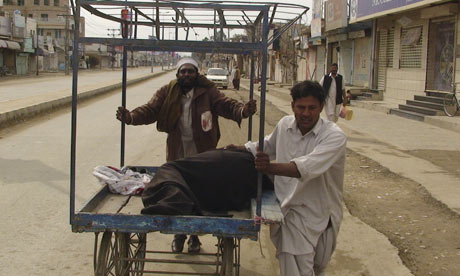
This town has seen a bloody surge in sectarian schism, which has caused the loss of hundreds of innocent lives. Being somewhat neglected by the electronic media coverage, only incidents involving bomb blasts are usually reported, whereas target killings on a day-to-day basis are not usually reported by the local newspapers and TV channels.
On August 19, 2008 a suicide bomber targeting Shias blew himself up in a hospital waiting room, killing 32 people,[8] including seven police officers. It is believed that the attack is one of several by the Taliban, who have taken responsibility for it, intending to demonstrate their reach and pressure the government to call off its offensive in Swat and the Bajaur Agency of the Federally Administered Tribal Areas, which had begun less than two weeks previously.[9][10]
On November 21, 2008, Shiite religious leader Allama Nazir Hussain Shah was shot dead in sectarian killing along with Shah Iqbal Hussain. During his funeral prayers, a suicide bomber blew himself up, killing 9 people and injuring 39.Once again, on February 20, 2009 a suicide bomber blew himself during a funeral procession of a Shia local, killing more than 32 while injuring 157.[11]
On July 30, 2013 at around 11.15 pm, around 150 militants launched a major attack on central jail and released more than 200 prisoners and announced that if police or security forces try to resist or launch any operation, they would attack and blow up the city. This tussle continued for more than 2 hours. Later, banned Tehrik-e-Taliban Pakistan accepted the responsibility of these attacks.[12][13]
Demographics
According to the 1901 census the population of Dera Ismail Khan was 31,737, of whom 18,662 were Muslims, 11,486 Hindus, and 1,420 Sikhs. Of the total, 3,450 lived in the cantonment.[14] After the independence, many of the city's Hindu residents settled in India, primarily in Model Town, Vijay Nagar and Derawal Nagar colony in Delhi.[15]
In 1999 it had a population of 31,737, down from its 1981 census tally of 64,358. The population is a mix of ethnic Saraikis, Baloch and Pashtun segments, with a significant number of Urdu-speaking immigrants. Urdu, the national language, is understood and spoken by the majority of residents, Pashto is also spoken, primarily within the Pashtun community.
Communication
The city is connected to Bannu via the highway, which further connects it to the provincial capital of Peshawar via Kohat and Darra Adam Khel. Another road connects D. I. Khan to Mianwali through Chashma Barrage. The third major road connects it to Bhakkar in Punjab, situated on the eastern bank of the Indus River. A bridge on the Indus River was constructed in the early 1980s, before which the approach to Bhakkar was made through a boat bridge.
The city has telephone, telegraph, and internet facilities — although the telegraph has recently been abandoned, in line with the government policy of transitioning away from telegraph communications throughout the country.
Educational institutions
The city is home to many educational institutions, including:
- Government College Dera Ismail Khan which later on became Government Degree College No.1, D.I.Khan, is one of the oldest institutions of D.I.Khan like Islamia School or Mission School. It was established way back in May 1921 as Vedic Brathery College by the then Hindus of Dera Ismail Khan. In 1947 it was handed over to one of the famous educationist of D.I.Khan Mr. Qureishi Ahmad Ali Sadiq who hired Muslim staff for it and made Khan Faiz Muhammad Khan as the first principal of the college after partition by calling him from Baluchistan.These days Government Degree College No.1, D.I.Khan is the leading BS college of D.I.Khan and is the first fully functional BS College in the entire Khyber Pakhtunkhwa province of Pakistan.This college is the mother institution of Gomal University D.I.Khan.(17)
- Punjab Group of Colleges_Meraj Campus
- St Helen's High School (Father School)
- University Wensam College
- Gomal University
- Gomal Medical College
- Al-Khair University
- Allama Iqbal Open University
- Qurtuba University of Science & Information Technology[16]
Tourist areas
Although the city is relatively new, rebuilt following the 1823 flood, many of its original structures remain — the original wall is still visible around the old city. A popular tourist destination is a pre-Islamic fort called Bilot, 30 miles (48 km) from the Dera Ismail Khan on Dera Ismail Khan – Chashma highway. These ruins are situated on a hill.
A sacred Sikh shrine is located in the Chota Bazaar of Dera Ismail Khan; Guru Nanak visited this place during his fourth itinerary. At the site where he stayed a dharamsala was built by his devotees. It is a large building, its main gate opens in the Chota Bazaar. Inside this door there is a double-storey square building, where Prakash used to take place. There are residential rooms around this building for pilgrims. Inside the darbar there is a thara sahib (pious seat) where Guru Nanak Dev Ji once sat. The Government Higher Secondary School No. 3 is currently housed in this building. This dharamsala was maintained by SGPC before 1947 and presently it is in the hands of the Waqf department. The banks of the Indus River are an attractive place for tourists. On the right side of Rehmania Street, the house of an Hindu Zamindar – Bagai Mahal is a very old building of D. I. Khan, as is the Satures Building in Shieve Shah Muhalla. Allied School, Kamal Campus, Diyal Road, Dera Ismail Khan
Economic production in the district
One of the most famous products of this district is the "Dhakki date", which is exported to the Middle East, United States, and Europe. This date or khajoor is grown in the nearby village of Dhakki, 49 km away on Chashma Road. This district also produces wheat, sugar cane, rice, and a famous variety of mango called the langra. The most desirable langras are grown in the village of Panyala. Nowadays D I Khan is increasingly exporting another type of dried date called chooara. The majority of chooara are produced in Dhakki, Mitrah Abad,Kathgarh and Saidu Wali. Kathgarh is a village situated in Tehsil Pahar Pur, about 43 km from D I Khan near Pahar Pur(By Nisar Hussain Chishti). There are also coal mines in the village of Kathgarh, on the edge of CRBC Canal.
The bazaars of the city all converge in one area, called Chowgalla (literally "intersection"). Major bazaars include Topanwala Bazaar, Bhatiya Bazaar, Muslim Bazaar, Commissioneri Bazaar, Kalan Bazaar and Bakhiri Bazaar.
Like other cities and towns of the Saraiki-speaking belt, Dera Ismail Khan is famous for a dessert delicacy called sohan (halwa). Shops selling this sweet are primarily situated in Topawaala Bazaar, the old and the best halwa is produced and sold by three shops named Asli Sufi Sohn Halwa, Pak Sweet (Mun-Milan Sohn Halwa) and Qadimi Sohn Halwa. The city is also known for a dish called sobat.
Dera Ismail Khan is famous for its lacquered woodwork, glass and ivory ware, mats, and sarongs. Newer industries within the city include sugar, soap, textile and oil milling. Radio Pakistan is situated in D. I. Khan., telecasting Saraiki and Pashto programmes. CRBC Canal is the major canal that provides water for irrigation. There is a basti in D.I. Khan, which is called Dheko Wali Basti. ′ WAIST COATS also called waskat that is atraditional and national dress part of the country are made here in a very traditional method in ′KHALID SHARIF TAILORS′.From here these waist coats are gifted and transported nearly all the province and also to Afghanistan.
Transport
The nearest railway station is 20 km away at Darya Khan, on the eastern and opposite bank of the Indus River.
- Air link via Pakistan International Airlines to all major cities of Pakistan
- Daewoo Bus Service to all major cities of Pakistan
- Karachi Bus Terminal
- Lahore Adda
- Baloch Runners
- Main Lari Adda D. I. Khan
- Niazi Bus Stand
- Proa Adda
- Tank Adda
- Kulachi Flying Coach Adda
- Khan Bus and Transport Services.
- Daraban Kalan Flying Coach Adda
A major traffic incident in August 2016 in the area resulted in the deaths of at least 13 people and the injury of over 35 people after a large traffic collision involving a truck and a bus carrying about 50 people.[17] The death toll is expected to rise.[18]
See also
References
- ↑ Tehsils & Unions in the District of D.I. Khan – Government of Pakistan. Nrb.gov.pk. Retrieved on 2012-06-01.
- 1 2 3 4 5 Dera Ismail Khān Town – Imperial Gazetteer of India, v. 11, p. 269. Dsal.uchicago.edu. Retrieved on 2012-06-01.
- ↑ http://dsal.uchicago.edu/cgi-bin/philologic/getobject.pl?c.1:1:1681.soas
- ↑
 One or more of the preceding sentences incorporates text from a publication now in the public domain: Chisholm, Hugh, ed. (1911). "Dera Ismail Khan". Encyclopædia Britannica. 8 (11th ed.). Cambridge University Press. p. 64.
 - ↑ Aminllah Khan Gandpar; Tarikh-i-Sar Zamin-i-Gomal, National Book Foundation Islamabad, page 45.
- ↑ "Dera Ismail Khan Climate Normals 1961-1990". National Oceanic and Atmospheric Administration. Retrieved January 16, 2013.
- ↑ http://ecp.gov.pk/ERConsolidated2013/SearchFull2013.aspx?constituency=PA&constituencyid=PK-64
- ↑ Govt talks tough as inaction against hate-mongers is assailed in NA – Dawn Pakistan. August 21, 2008
- ↑ "30 killed in DI Khan suicide attack". Daily Times. August 20, 2008. Retrieved 2008-08-24.
- ↑ Cogan, James (August 23, 2008). "Military offensive displaces 300,000 in north-west Pakistan". World Socialist Web Site. Retrieved 2008-08-24.
- ↑ BBCUrdu.com | پاکستان | ڈی آئی خان،جنازے پرحملہ 8 ہلاک. (in Urdu). 21 November 2008. Retrieved on 2012-06-01.
- ↑ Leading News Resource of Pakistan. Daily Times (2009-02-21). Retrieved on 2012-06-01.
- ↑ JPG image (2009-2-20)
- ↑ Dera Ismail Khān Town – Imperial Gazetteer of India, v. 11, p. 268. Dsal.uchicago.edu. Retrieved on 2012-06-01.
- ↑ "Colonies, posh and model in name only!". NCR Tribune. Retrieved 2007-12-16.
- ↑ http://www.qurtuba.edu.pk/
- ↑ http://pakobserver.net/2016/08/03/13-killed-35-injured-in-truck-bus-crash/
- ↑ http://www.khaleejtimes.com/20160802/7497/no-title
17.It is a shame Government Degree College No.1, D.I.Khan was not there in the list of notable educational institutions of D.I.Khan which can never be complete without the mention of this famous Alma mater.Being the current serving head of this illustrious institution it was my duty to name and highlight it here. Professor Syed Abid Hussain, Principal, Government Degree College no.1, D.I.Khan