Düne
|
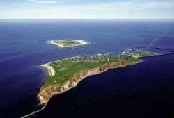
Picture of Düne taken from airplane, in the background the island Heligoland | |
 Düne | |
| Geography | |
|---|---|
| Location | German Bight |
| Coordinates | 54°11′5″N 7°54′44″E / 54.18472°N 7.91222°ECoordinates: 54°11′5″N 7°54′44″E / 54.18472°N 7.91222°E |
| Archipelago | Heligoland |
| Area | 0.7 km2 (0.27 sq mi) |
| Administration | |
| State | Schleswig-Holstein |
| District | Pinneberg district |
| Municipality | Heligoland |
| Demographics | |
| Population | unpopulated |
| Additional information | |
| Official website | helgoland.de |

Düne (Danish: Dynen, North Frisian: de Halem) is one of two islands in the German North Sea Coast Area that belong to the Archipelago of Heligoland, the other being Heligoland proper.
Geography
The small island Düne is part of the German State Schleswig-Holstein. Situated 1 mile to the east of the main island Heligoland, Düne is part of the natural landscape Helgoländer Felssockel [Heligoland rock core]. The island measures 0.78 mile in length and 0.53 mile in width.
History
Until the 17th century, Düne was connected to Heligoland. On New Year's Eve 1721 a big storm surge separated the dunes from Heligoland. Therefore, the island that arose was called Düne (English: Dune). In 1935 the size of the island was 10 hectares (25 acres). In 1940 the Nazi government increased the size of the island to 40 hectares (99 acres). This increase was for military use. An airfield was built that is still used today. The Heligoland Airport has two runways, of which the longest is 500 metres (1,600 feet). The area of the artificial island is forty hectares (99 acres).
External links
- Düne at the website of Heligoland municipality
| West Frisian Islands (Netherlands) |
|  | |||||||||
|---|---|---|---|---|---|---|---|---|---|---|---|
| East Frisian Islands (Germany) |
| ||||||||||
| Heligoland Bight (Germany) | |||||||||||
| North Frisian Islands (Germany) |
| ||||||||||
| Danish Wadden Sea Islands (Denmark) |
| ||||||||||