Cyclone Lothar and Martin
Lothar and Martin[1] were violent European windstorms which swept across western and central Europe during a period of 36 hours in December 1999. The storms caused major damage in France, southern Germany, Switzerland, and Italy. Throughout the affected region, 140 people were killed[2] and damage was estimated at €9.9 billion.[3][4] Both of these storms were associated with an intense jet stream aloft and benefitted from latent heat release through atmosphere-ocean exchange processes. Lothar and Martin together left 3.4 million customers in France without electricity, and forced EdF to acquire all the available portable power generators in Europe, with some even being brought in from Canada.[5] These storms brought a fourth of France's high-tension transmission lines down and 300 high-voltage transmission pylons were toppled. It was one of the greatest energy disruptions ever experienced by a modern developed country.[2]

Meteorological history
December 1999 saw a series of heavy winter storms cross the North Atlantic and western Europe. In early December, Great Britain and Denmark were hit by Cyclone Anatol which caused severe damage in Denmark. A second storm then crossed Europe on 12 December.[6] A very deep and sizeable 938 mb depression moved across Britain on the night of 24–25 December, this set up a large area of westerly flow into Europe which brought Lothar. This highly unstable situation inevitably meant low predictability, and saw an unusually straight and strong jet stream (similar circumstances were also noted the day before the arrival of the Great Storm of 1987).[7] Storm Martin then struck France and central Europe from 26 to 28 December 1999. At the end of January 2000 two additional damaging storms crossed Denmark and the northern part of Germany.[6]
Forecast
Windstorm Lothar was not well predicted, with one meteorologist later claiming that forecasts could be split into those that were poor and those that were very poor.[7] According to some forecasts, the storm was predicted to pass through the United Kingdom, while others failed to predict significant intensification at all. The strong jet stream that was the chief cause of the instability was well predicted by the European Centre for Medium-Range Weather Forecasts 9 days earlier.[7] Approximately 24 hours before the storm hit France, Météo-France issued a warning of a strong storm with the correct path, but two hours before the storm hit Paris, inland windspeeds were still predicted to be between 90–130 km/h (56-81 mph), rather than the 125–175 km/h (80-110 mph) range actually experienced.[7]
MeteoSwiss found the storm Lothar extremely difficult to predict, as even the large forecast models of international weather services initially overlooked the small disturbance above the Atlantic Ocean which formed the storm. Consequently, the power and extent of the storm was only recognized in the early morning of 26 December, which resulted in shorter warning times in Switzerland.[6] In a number of places, officials failed to realize the importance of the warnings, so they were not passed on to the public as they should have been. It is presumed that this occurred because of the holidays.[6]
The German Weather Service (Deutscher Wetterdienst) was criticised for not issuing a storm warning for Lothar in contrast to the weather services of other countries and private German services, apparently due to a software bug.
Lothar
 Track of the central low pressure of Lothar | |
| Type |
European windstorm Extratropical cyclone |
|---|---|
| Formed | 25 December 1999 |
| Dissipated | 27 December 1999 |
| Lowest pressure | 960 mb (28 inHg) |
| Highest gust | 259 km/h (161 mph) |
| Areas affected | Western Europe |
During the first storm Lothar, wind speeds reached around 150 km/h (93 mph) in low-lying areas and more than 250 km/h (160 mph) on some mountains. In less than half a day the storm tore across France, Belgium and Germany, only finally beginning to weaken as it crossed Poland. The storm's compact internal pressure gradients generated winds which were comparable to those of a Category 2 hurricane.[2]
The Paris region was strongly affected by the storm during the early morning. The Palace of Versailles and its monumental park were considerably damaged (over 10.000 trees were lost within two hours, including valuable specimens planted by Napoleon and Marie Antoinette). Other cultural heritage, forests and public gardens throughout the area were as severely affected by the hurricane-force winds. Public life was disrupted due to power outages and blocked infrastructure. Besides buildings and infrastructure, forests, such as the Black Forest in Germany, suffered major damage resulting in substantial economic loss.
Lothar successor
A case study of the Manual of Synoptic Satellite Meteorology featured by the Austrian Meteorological Institute (ZAMG) identified an area of secondary cyclogenesis which brought gusts in excess of 90 km/h to Northern France, Belgium and Southwestern Germany.[8] The system formed in the wake of Lothar, and crossed Europe before the arrival of the later storm Martin. The identification of this secondary area and its frontal systems contrasts with the analysis of the German Weather Service which suggested that solely a 'trough line' crossed Germany.[9]
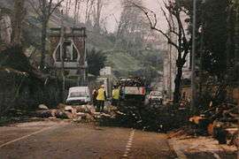 Clearing damage in Angoulême 28 December 1999 | |
| Formed | 26 December 1999 |
|---|---|
| Dissipated | 28 December 1999 |
| Lowest pressure | 963 mb (28.4 inHg) |
| Highest gust | 200 km/h (120 mph) |
| Areas affected | Western Europe |
Martin
Martin was a violent European windstorm which crossed southern Europe (France, Spain, Switzerland and Italy) on 27–28 December 1999, one day after Lothar. Wind speeds reached around 200 km/h in French département of Charente-Maritime (198 km/h in Oleron island and 194 km/h in Royan),[10] sustained winds of over 140 km/h were observed in Gironde (Cap Ferret, 173 km/h), Vendée (Île d'Yeu, 162 km/h) Haute-Vienne (Limoges, 148 km/h)[11] and Haute-Garonne (Toulouse, 141 km/h). The storm caused 30 fatalities. Building and infrastructures suffered major damage, and mains power and safety systems were knocked out due to flooding at the Blayais Nuclear Power Plant, resulting in a 'level 2' event on the International Nuclear Event Scale.[12]
Aftermath
These storms caused extensive damage to property and trees (13,000,000 m3/459,090,667 ft3 of wood in Switzerland[13] and 140,000,000 m3/4,944,053,340 ft3 were felled in France.)[14] The French and German national power grids were also left badly affected.
Highest winds
Lothar
| Country | Place | Speed | Country | Place | Speed |
|---|---|---|---|---|---|
| France | Ploumanac'h | 148 km/h (92 mph) | Switzerland[15] | La Chaux-de-Fonds | 134.6 km/h (83.6 mph) |
| Île de Groix | 162 km/h (101 mph) | Chasseral | 177.5 km/h (110.3 mph) | ||
| Rennes | 126 km/h (78 mph) | La Dôle | 201.2 km/h (125.0 mph) | ||
| Nantes | 126 km/h (78 mph) | Geneva | 103.7 km/h (64.4 mph) | ||
| Alençon | 166 km/h (103 mph) | Col du Grand-Saint-Bernard | 178.6 km/h (111.0 mph) | ||
| Rouen | 140 km/h (87 mph) | Évolène | 124.6 km/h (77.4 mph) | ||
| Chartres | 144 km/h (89 mph) | Lucerne | 141.5 km/h (87.9 mph) | ||
| Paris (Parc Montsouris) | 169 km/h (105 mph) | Zurich | 157.8 km/h (98.1 mph) | ||
| Paris Eiffel Tower | >216 km/h (134 mph) | Schaffhausen | 162 km/h (101 mph) | ||
| Orly | 173 km/h (107 mph) | Säntis | 229.7 km/h (142.7 mph) | ||
| Dijon | 126 km/h (78 mph) | Germany[16] | Weinbiet | 184 km/h (114 mph) | |
| Metz | 155 km/h (96 mph) | Stuttgart | 144 km/h (89 mph) | ||
| Nancy | 144 km/h (89 mph) | Karlsruhe | 151 km/h (94 mph) | ||
| Colmar | 165 km/h (103 mph) | Grosser Arber | 162 km/h (101 mph) | ||
| Strasbourg | 144 km/h (89 mph) |
Martin
| Country | Place | Speed |
|---|---|---|
| France | Saint-Denis-d'Oléron (17) | 198 km/h |
| Royan (17) | 194 km/h | |
| Cap Ferret (33) | 173 km/h | |
| Île d'Yeu (85) | 162 km/h | |
| Clermont-Ferrand (62) | 159 km/h | |
| La Rochelle (17) | 151 km/h | |
| Limoges (87) | 148 km/h | |
| Bordeaux (33) | 144 km/h | |
| Toulouse (31) | 141 km/h |
See also
References
- ↑ "1999 Windstorm naming lists". FU-Berlin. Retrieved 9 December 2011.
- 1 2 3 Tatge, Yörn. "Looking Back, Looking Forward: Anatol, Lothar and Martin Ten Years Later". Air-Worldwide. Retrieved 30 May 2013.
- ↑ "Archived copy". Archived from the original on 2010-09-23. Retrieved 2013-05-09.
- ↑
- ↑ "Impacts of Severe Storms on Electric Grids" (PDF). Union of the Electricity Industry – EURELECTRIC. 2006. Retrieved 5 January 2013.
- 1 2 3 4 Brüdl, M.; Rickli, C. (2002). "The storm Lothar 1999 in Switzerland – an incident analysis." (PDF). Forest Snow and Landscape Research. 77: 207–216. Retrieved 1 June 2013.
- 1 2 3 4 "Windstorms Lothar and Martin" (PDF). RMS Risk Management Solutions. Retrieved 31 May 2013.
- ↑ "Storm Catastrophe 25 - 28 December 1999 - Lothar and Lothar Successor". ZAMG. Retrieved 16 July 2013.
- ↑ Welzenbach, F. (2010). "Phenomenological examination of 'Lothar Successor' - the forgotten storm after Christmas 1999" (PDF). unknown. Retrieved 16 July 2013.
- ↑ "Les vents de l'enfer". L'est républicain. 9 December 2009. Archived from the original on 4 March 2010. Retrieved 8 March 2010.
- ↑ "Les tempêtes de décembre 1999". Météo-France. 28 December 1999. Retrieved 8 March 2010.
- ↑ COMMUNIQUE N°7 – INCIDENT SUR LE SITE DU BLAYAIS Archived May 27, 2013, at the Wayback Machine. ASN, published 30 December 1999, Retrieved 22 March 2011
- ↑ Michel Spicher (2005-01-04). "L'ouragan Lothar, un cataclysme dans le monde forestier" (in French). Site officiel du Canton de Fribourg (Suisse). Retrieved 2006-12-29.
- ↑ Michel Denis (2004-05-10). "Expertise collective suite aux dégâts en forêt lors des tempêtes de décembre 1999" (in French). Cemagref. Retrieved 2006-12-29.
- ↑ "Cartes des vents lors de la tempête Lothar" (in French). Institut suisse de météorologie (ISM). Archived from the original on 2007-09-27. Retrieved 2007-05-07.
- ↑ "Rapports sur Lothar" (PDF) (in German). Deutscher Wetterdienst (German weather service). Retrieved 2007-05-07.
External links
- Met Office, University of Exeter & University of Reading Extreme Wind Storm Catalogue: Lothar and Martin
- (French) Les tempêtes en France
- Details of damage in France (pdf)
| Historical |  | |
|---|---|---|
| 1900s |
| |
| 2000s | ||
| 2015– Name our Storms | ||
| See also | ||