Cutlerville, Michigan
| Cutlerville, Michigan | |
|---|---|
| Census-designated place (CDP) & Unincorporated community | |
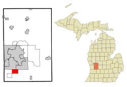 Location of Cutlerville, Michigan | |
| Coordinates: 42°50′27″N 85°39′49″W / 42.84083°N 85.66361°W | |
| Country | United States |
| State | Michigan |
| County | Kent |
| Area | |
| • Total | 6.0 sq mi (15.5 km2) |
| • Land | 6.0 sq mi (15.5 km2) |
| • Water | 0.0 sq mi (0.0 km2) |
| Elevation | 676 ft (206 m) |
| Population (2010) | |
| • Total | 14,370 |
| • Density | 2,395.0/sq mi (927.1/km2) |
| Time zone | Eastern (EST) (UTC-5) |
| • Summer (DST) | EDT (UTC-4) |
| ZIP codes | 49508, 49548 |
| Area code(s) | 616 |
| FIPS code | 26-19500[1] |
| GNIS feature ID | 0624256[2] |
Cutlerville is an unincorporated community in Kent County in the U.S. state of Michigan. It is a census-designated place (CDP) for statistical purposes. The population was 15,114 at the 2000 census.
The Cutlerville CDP is just south of the cities of Wyoming and Kentwood and straddles the boundary between Byron Township on the east and Gaines Township on the north.[3]
John Cutler, who came here from New York State with his wife and ten children, bought 312 acres (1.26 km2) in 1853 and built a log cabin. In 1891, his son John I. Cutler, built the Cutler mansion, which in 1910 became the nucleus of the Pine Rest Christian Mental Health Services.[4]
Geography
According to the United States Census Bureau, the community has a total area of 6.0 square miles (16 km2), all land.
Demographics
As of the census[1] of 2000, there were 15,114 people, 5,975 households, and 3,907 families residing in the community. The population density was 2,527.2 per square mile (975.8/km²). There were 6,253 housing units at an average density of 1,045.5 per square mile (403.7/km²). The racial makeup of the community was 88.93% White, 4.61% African American, 0.58% Native American, 1.64% Asian, 0.02% Pacific Islander, 1.96% from other races, and 2.26% from two or more races. Hispanic or Latino of any race were 4.49% of the population.
There were 5,975 households out of which 33.2% had children under the age of 18 living with them, 47.8% were married couples living together, 13.4% had a female householder with no husband present, and 34.6% were non-families. 25.6% of all households were made up of individuals and 6.0% had someone living alone who was 65 years of age or older. The average household size was 2.49 and the average family size was 2.99.
In the community the population was spread out with 27.4% under the age of 18, 10.6% from 18 to 24, 32.7% from 25 to 44, 18.9% from 45 to 64, and 10.5% who were 65 years of age or older. The median age was 32 years. For every 100 females there were 97.8 males. For every 100 females age 18 and over, there were 94.4 males.
The median income for a household in the community was $40,809, and the median income for a family was $43,972. Males had a median income of $36,085 versus $24,989 for females. The per capita income for the community was $19,648. About 4.4% of families and 7.2% of the population were below the poverty line, including 9.3% of those under age 18 and 5.2% of those age 65 or over.
Notable residents (past and present)
- Carlee Hoffman – Paralympic Games gold medalist
- Brian Diemer – Bronze medalist in the 3000 meter steeplechase at the 1984 Summer Olympics
- Aaron Gull - Professional Bowler PBA Tour
References
- 1 2 "American FactFinder". United States Census Bureau. Archived from the original on 2013-09-11. Retrieved 2008-01-31.
- ↑ U.S. Geological Survey Geographic Names Information System: Cutlerville, Michigan
- ↑ Cutlerville CDP, Michigan – Reference Map – American FactFinder, U.S. Census Bureau, 2000 census
- ↑ Romig, Walter (1986) [1973]. Michigan Place Names. Detroit, Michigan: Wayne State University Press. ISBN 0-8143-1838-X.
Municipalities and communities of Kent County, Michigan, United States | ||
|---|---|---|
| Cities | 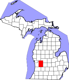 | |
| Villages | ||
| Charter townships | ||
| General law townships | ||
| CDPs | ||
| Other unincorporated communities | ||
| Footnotes | ‡This populated place also has portions in an adjacent county or counties | |
Coordinates: 42°50′27″N 85°39′49″W / 42.84083°N 85.66361°W