Cutler Stack
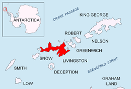 Location of Livingston Island in the South Shetland Islands. | |
| Geography | |
|---|---|
| Location | Antarctica |
| Coordinates | 62°36′44.5″S 60°58′51.5″W / 62.612361°S 60.980972°W |
| Archipelago | South Shetland Islands |
| Length | 0.17 km (0.106 mi) |
| Width | 0.15 km (0.093 mi) |
| Highest elevation | 16 m (52 ft) |
| Administration | |
| Demographics | |
| Population | 0 |
| Additional information | |
| Administered under the Antarctic Treaty System | |

Cutler Stack is a sea stack extending 170 by 150 m (186 by 164 yd) and rising to 16 m (52 ft), lying off Nedelya Point in the south of Barclay Bay, western Livingston Island in the South Shetland Islands, Antarctica. The area was visited by early 19th century sealers.
The feature is named after Captain Benjamin Cutler, part owner of the American brig Frederick that visited the area in 1820-21, and Master of the sealing schooner Free Gift that visited the area in 1821-22; his name was found carved on a piece of whale vertebra excavated from a stone hut on Byers Peninsula by a FIDS survey party in 1957-58.
Location
The stack is located at 62°36′44.5″S 60°58′51.5″W / 62.612361°S 60.980972°W which is 300 m (328 yd) north-northwest of Nedelya Point, 2.8 km (1.7 mi) east-northeast of Lair Point and 4.72 km (2.93 mi) southwest of Rowe Point (British mapping in 1968, detailed Spanish mapping in 1992, and Bulgarian mapping in 2009).
See also
- Composite Antarctic Gazetteer
- List of Antarctic islands south of 60° S
- SCAR
- Territorial claims in Antarctica
Maps
- Península Byers, Isla Livingston. Mapa topográfico a escala 1:25000. Madrid: Servicio Geográfico del Ejército, 1992.
- L.L. Ivanov. Antarctica: Livingston Island and Greenwich, Robert, Snow and Smith Islands. Scale 1:120000 topographic map. Troyan: Manfred Wörner Foundation, 2009. ISBN 978-954-92032-6-4