Currahee Mountain
| Currahee Mountain | |
|---|---|
 Currahee Mountain | |
| Highest point | |
| Elevation | 1,735 ft (529 m) NAVD 88[1] |
| Coordinates | 34°31′45.21″N 83°22′33.18″W / 34.5292250°N 83.3758833°WCoordinates: 34°31′45.21″N 83°22′33.18″W / 34.5292250°N 83.3758833°W[1] |
| Geography | |
| Location | Stephens County, Georgia, U.S. |
| Parent range | Blue Ridge Mountains |
| Topo map | USGS Ayersville 34083-E |
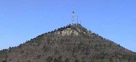
Currahee Mountain is a mountain located in Stephens County, Georgia, near Toccoa. The name appears to be derived from the Cherokee word (quu-wa-hi) meaning "stand alone."[2][3] Technically a part of the Georgia Piedmont or "foothill" province, Currahee Mountain rises abruptly about 800 vertical feet (240 m) above the local topography and is the highest peak in Stephens County. Part of the mountain is in the Chattahoochee National Forest. On clear days, the peak's 1,735-foot (529 m) summit is visible for many miles and is a prominent landmark to the southeast of Georgia's Blue Ridge Mountain crest.
Currahee Mountain is one of the landmarks[4] used in the Treaty of Hopewell.[5] It was also used by Benjamin Hawkins to run the Hawkins Line.[6][7]
On October 12, 1864, Confederate troops defeated Union troops at the Battle of Narrows, also called the Battle of Currahee, during the Civil War. The Confederate victory is said to have saved the area from pillage by Union troops. Casualties were small and the wounded were cared for by neighbors.[8]
The mountain was made famous internationally by Tom Hanks' and Steven Spielberg's television miniseries Band of Brothers, in which it was featured as a training site of the American Paratroopers at Camp Toccoa,[9] Georgia, where they ran up and down Currahee. The name of the mountain became the motto for these paratroopers including the famous quote: "3 Miles up, 3 Miles down". The nickname of the 506th Infantry Regiment, of which Easy Company was a part, is "Currahee".
Currahee is currently the site of the Annual Currahee Challenge, a three- and six-mile race on the mountain that occurs in the fall.[10] It is also a popular destination for rock climbing and rappelling.
One of the radio towers at the top holds NOAA Weather Radio station WWH24, serving parts of northeast Georgia and upstate South Carolina from NWS Greer.
References
- 1 2 "Currahee RM 4". NGS data sheet. U.S. National Geodetic Survey. Retrieved 2008-12-10.
- ↑ Krakow, Kenneth K. (2002). Georgia Place-names. Macon, Ga: Winship Press. ISBN 0-915430-00-2. Retrieved 2008-12-10.
- ↑ "The Names Stayed". Calhoun Times and Gordon County News. August 29, 1990. p. 64. Retrieved 29 April 2015.
- ↑ Kappler, Charles J. (1904). Indian Affairs: Laws and Treaties, Vol. II. Washington: Government Printing Office. p. 9. Retrieved 13 May 2016.
- ↑ Twohig, Dorothy (1993). Washington’s Memoranda on Indian Affairs, 1789. Charlottesville: University Press of Virginia. pp. 468–494. Retrieved 2 November 2016.
- ↑ "Hawkins Line". GeorgiaInfo: an Online Georgia Almanac. Retrieved 18 May 2016.
- ↑ Hawkins, Benjamin (2003). The Collected Works of Benjamin Hawkins, 1796-1810. Tuscaloosa: University of Alabama Press. p. 14. ISBN 9780817313678. Retrieved 18 May 2016.
- ↑ Cooksey, Elizabeth B. (2014). Habersham County. New Georgia Encyclopedia. Retrieved 11 May 2016.
- ↑ "Currahee Mountain". Georgia.org. Retrieved 2008-12-10.
- ↑ "Currahee Challenge". Retrieved 2015-02-06.
External links
- "Currahee Mountain". Geographic Names Information System. United States Geological Survey. Retrieved 2008-12-10.
- "Currahee Mountain, Georgia". Peakbagger.com. Retrieved 2008-12-01.
- Indian Boundary historical marker