Curly Bear Mountain
| Curly Bear Mountain | |
|---|---|
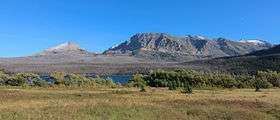 Divide Mountain and Curly Bear Mountain | |
| Highest point | |
| Elevation | 8,099 ft (2,469 m) [1] |
| Coordinates | 48°39′32″N 113°27′21″W / 48.65889°N 113.45583°WCoordinates: 48°39′32″N 113°27′21″W / 48.65889°N 113.45583°W[2] |
| Geography | |
| Location | Glacier County, Montana, U.S. |
| Parent range | Lewis Range |
| Topo map | USGS Saint Mary, MT |
Curly Bear Mountain (8,099 feet (2,469 m)) is located in the Lewis Range, Glacier National Park in the U.S. state of Montana.[1] The mountain is located south of Saint Mary Lake near the eastern border of the park adjacent to the Blackfoot Indian Reservation.
See also
| Wikimedia Commons has media related to Curly Bear Mountain. |
References
- 1 2 "Curly Bear, Montana" (Map). My Topo (USGS Quads). Retrieved 2010-03-20.
- ↑ "Curly Bear Mountain". Geographic Names Information System. United States Geological Survey. Retrieved 2010-09-26.
This article is issued from Wikipedia - version of the 2/19/2016. The text is available under the Creative Commons Attribution/Share Alike but additional terms may apply for the media files.