Crystal Bay, Nevada
| Crystal Bay, Nevada | |
|---|---|
| Census-designated place | |
|
| |
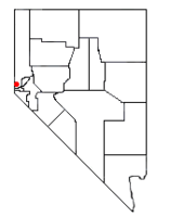 Location of Crystal Bay, Nevada | |
| Coordinates: 39°13′40″N 120°0′16″W / 39.22778°N 120.00444°WCoordinates: 39°13′40″N 120°0′16″W / 39.22778°N 120.00444°W | |
| Country | United States |
| State | Nevada |
| Area | |
| • Total | 0.8 sq mi (2.0 km2) |
| • Land | 0.5 sq mi (1.2 km2) |
| • Water | 0.3 sq mi (0.8 km2) |
| Elevation | 6,400 ft (2,000 m) |
| Population (2010) | |
| • Total | 305 |
| • Density | 390/sq mi (150/km2) |
| Time zone | Pacific (PST) (UTC-8) |
| • Summer (DST) | PDT (UTC-7) |
| FIPS code | 32-16700 |
Crystal Bay is a census-designated place (CDP) in Washoe County, Nevada on the north shore of Lake Tahoe. The population was 305 at the 2010 census.[1] It is part of the Reno−Sparks Metropolitan Statistical Area. Prior to 2010, it was listed by the U.S. Census Bureau within the Incline Village–Crystal Bay CDP.
Geography
Elevation ranges from 6,229 feet (1,899 m) on the shore of Lake Tahoe to over 6,800 feet (2,100 m) above sea level.[2] The CDP is located on the north shore of Lake Tahoe, adjacent to the California state line.
According to the United States Census Bureau, the CDP has a total area of 0.77 square miles (2.0 km2), of which 0.46 square miles (1.2 km2) is land and 0.31 square miles (0.8 km2), or 42.12%, is water.[1]
Climate
| Climate data for Incline Village–Crystal Bay, Nevada | |||||||||||||
|---|---|---|---|---|---|---|---|---|---|---|---|---|---|
| Month | Jan | Feb | Mar | Apr | May | Jun | Jul | Aug | Sep | Oct | Nov | Dec | Year |
| Average high °F (°C) | 39.4 (4.1) |
40.6 (4.8) |
44.2 (6.8) |
49.3 (9.6) |
58.1 (14.5) |
65.7 (18.7) |
73.2 (22.9) |
73.4 (23.0) |
68.4 (20.2) |
59.7 (15.4) |
49.5 (9.7) |
42.1 (5.6) |
55.3 (12.94) |
| Average low °F (°C) | 20.5 (−6.4) |
23.7 (−4.6) |
28.9 (−1.7) |
36.3 (2.4) |
41 (5.0) |
47.7 (8.7) |
54.1 (12.3) |
54 (12.2) |
47.3 (8.5) |
42.6 (5.9) |
30.6 (−0.8) |
22.3 (−5.4) |
37.42 (3.01) |
| Average precipitation inches (mm) | 2.95 (74.93) |
3.1937 (81.12) |
2.4756 (62.88) |
1.378 (35.00) |
1.798 (45.67) |
1.0346 (26.28) |
0.3736 (9.49) |
0.6035 (15.33) |
0.9654 (24.52) |
2.1406 (54.37) |
3.2197 (81.78) |
2.9626 (75.25) |
23.0953 (586.62) |
| Source: National Weather Service | |||||||||||||
Education
The region is served by the Washoe County School District.
References
- 1 2 "Geographic Identifiers: 2010 Demographic Profile Data (G001): Crystal Bay CDP, Nevada". U.S. Census Bureau, American Factfinder. Retrieved January 16, 2013.
- ↑ U.S. Geological Survey, Kings Beach 7.5-minute quadrangle, 2012
Municipalities and communities of Washoe County, Nevada, United States | ||
|---|---|---|
| Cities |  | |
| CDPs | ||
| Unincorporated communities | ||
| Indian reservation | ||
| Indian colony | ||
| Ghost towns | ||