Crusnes
| Crusnes | ||
|---|---|---|
|
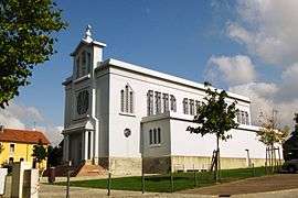
Eglise Sainte-Barbe | ||
| ||
 Crusnes | ||
|
Location within Grand Est region  Crusnes | ||
| Coordinates: 49°26′07″N 5°55′02″E / 49.4353°N 5.9172°ECoordinates: 49°26′07″N 5°55′02″E / 49.4353°N 5.9172°E | ||
| Country | France | |
| Region | Grand Est | |
| Department | Meurthe-et-Moselle | |
| Arrondissement | Briey | |
| Canton | Audun-le-Roman | |
| Intercommunality | Communauté de communes du Pays Audunois | |
| Government | ||
| • Mayor (2008–2014) | Serge Bertelle | |
| Area1 | 6.06 km2 (2.34 sq mi) | |
| Population (2007)2 | 1,666 | |
| • Density | 270/km2 (710/sq mi) | |
| Time zone | CET (UTC+1) | |
| • Summer (DST) | CEST (UTC+2) | |
| INSEE/Postal code | 54149 / 54680 | |
| Elevation |
350–436 m (1,148–1,430 ft) (avg. 371 m or 1,217 ft) | |
| Website | www.crusnes.mairie.com | |
|
1 French Land Register data, which excludes lakes, ponds, glaciers > 1 km² (0.386 sq mi or 247 acres) and river estuaries. 2 Population without double counting: residents of multiple communes (e.g., students and military personnel) only counted once. | ||

Crusnes (Luxembourgish: Krongen) is a commune in the Meurthe-et-Moselle department in north-eastern France.
See also
| Wikimedia Commons has media related to Crusnes. |
This article is issued from Wikipedia - version of the 10/8/2016. The text is available under the Creative Commons Attribution/Share Alike but additional terms may apply for the media files.