Croton River
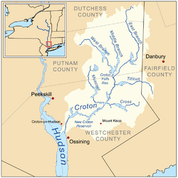
The Croton River (/ˈkroʊtən/ KROH-tən) is a river in southern New York that begins where its eastern and western tributaries join downstream from the Croton Falls Reservoir. Shortly downstream, the Croton River, along with its tributary, the Muscoot River, flows into the Muscoot Reservoir, after which it empties into the New Croton Reservoir, which feeds the New Croton Aqueduct supplying water to New York City. Excess water leaves the spillway at the New Croton Dam, and finally empties into the Hudson River at Croton-on-Hudson, New York at Croton Point, about 30 miles (50 km) north of New York City.[1] The river has a watershed area of 361 square miles (930 km2).[1]
History
Seeking to expand New York City's water supply, engineers of the city Aqueduct Commission designed in 1884 a 275-to-300-foot-high (84 to 91 m) masonry dam spanning the Croton River near its mouth. The resulting storage reservoir, impounding a 16-square-mile (41 km2) watershed, would hold 14.2 billion US gallons (54,000,000 m3) at full capacity.[2] The Croton Falls Dam was placed into service in 1911.
In the 1890s, rather than resorting to expensive filtration, New York City ordered the destruction or relocation of any village or hamlet threatening to pollute the Croton or its tributaries. Many were moved.
In the late 1990s, New York City stopped using water from the Croton as it became more and more unsuitable for drinking. In 2004, a project was started to rehabilitate the New Croton Aqueduct and build a filtration plant which is expected to come on line after 2015.[3]
See also
References
- 1 2 Institution of Civil Engineers (Great Britain) (1901). Minutes of proceedings of the Institution of Civil Engineers. The Institution. Retrieved 24 October 2011.
- ↑ Transactions of the American Society of Civil Engineers. American Society of Civil Engineers. 1912. p. 163. Retrieved 24 October 2011.
- ↑ http://tunnelingonline.com/nyc-dep-completes-rehab-124-year-old-new-croton-aqueduct/ NYC DEP Completes Rehab of 124 Year-old New Croton Aqueduct
Dutchess County, New York drainage basins | ||
|---|---|---|
| Basins | ||
Coordinates: 41°11′12″N 73°52′36″W / 41.18667°N 73.87667°W